Sermerssook ( grenl. Kommuneqarfik Sermersooq ) - since 2009, one of the four communes of Greenland .
| Commune | |||
| Sermersawok | |||
|---|---|---|---|
| grenl. Kommuneqarfik Sermersooq | |||
| |||
| A country | Denmark | ||
| Adm. center | Nuuk | ||
| History and Geography | |||
| Date of formation | 2009 | ||
| Area | 635,600 km² (2nd place ) | ||
| Timezone | UTC-1 - UTC-3 | ||
| Population | |||
| Population | 21 813 [1] people ( 2012 ) ( 1st place ) | ||
| Density | 0.034 people / km² (3rd place) | ||
| Official language | Greenlandic and Danish | ||
| Digital identifiers | |||
| ISO 3166-2 Code | GL-SM | ||
| Auto Code numbers | |||
| Official site | |||
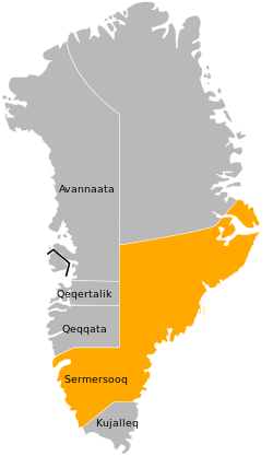 | |||
The population is 21,813 people ( 2012 ) [1] , living on the territory of 635.6 thousand km² . This is the most populated commune of Greenland, but 17,834 people live in the administrative center of the city of Nuuk itself . By territory, Sermerssook is second only to the Kaasuitsup commune.
Sermerssook is bordered by all other communes, as well as the unincluded territory of the Northeast Greenland National Park . The commune occupies the southern part of the former territory of West Greenland , with the exception of the extreme south and East Greenland, with the exception of the Greenland National Park in the north and the territory of Kuyallek in the extreme south. In the north-west, Kaasuitsup and Kekkata are bordered by 45 ° west longitude .
The western part, where Nuuk is located, is most suitable for settlements . The largest settlements on the east coast are Tasyilak (1850 inhabitants) and Illokkortormiut (530 inhabitants), located at the mouth of the largest fjord in the world Kangertitivak . The central part of the commune is a glacier .
The municipality has 18 of the 19 highest mountains in Greenland .