Maebashi ( 前 橋 市 Maebashi-si ) is the central city of Japan , located in the south-central part of Gumma Prefecture . Maebashi is the administrative center of this prefecture.
| Central city | |||||
| Maebashi | |||||
|---|---|---|---|---|---|
| jap. 前 橋 市 | |||||
 | |||||
| A country | |||||
| Prefecture | Gumma | ||||
| The mayor | |||||
| History and Geography | |||||
| Former names | Umayabashi | ||||
| Central city with | 2009 | ||||
| Square | 311.64 km² | ||||
| Center height | |||||
| Timezone | UTC + 9 | ||||
| Population | |||||
| Population | 340 041 people ( 2014 ) | ||||
| Density | 1091.13 people / km² | ||||
| Digital identifiers | |||||
| Postcode | 〒 371-8601 | ||||
| Code | 10201-6 | ||||
| Other | |||||
| Region | Kanto | ||||
| city.maebashi.gunma.jp (Japanese) | |||||


General information
Maebashi is one of the largest cities in the Kanto Plain , located in the middle reaches of the Tone River. Together with the neighboring city of Takasaki, it is one of the main industrial and commercial centers of Gumma Prefecture. There is also a city rail network connecting Maebashi with the cities of Sibukawa , Iesaki and Kiryu .
In the Middle Ages, the area of modern Maebashi was known as Umayabashi. Since the 17th century, Maebashi received its modern name and became the center of autonomous education of the Maebashi Khan, owned by the samurai of the Sakai and Matsudaira families.
Thanks to the active development of the Maebashi textile industry in the second half of the 19th century, the city was known as the “silk village”.
Geography
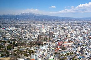
Maebashi is located in the eastern part of Honshu Island, in the north of the Kanto Plain, at the southern foot of Akagi Volcano.
The area of the city is 311.64 km² [1] , the population is 340,041 people (July 1, 2014) [2] , the population density is 1,091.13 people / km². Its length from north to south is 25 km, and from west to east - about 20 km.
On the territory of Maebashi, the largest river of the Kanto Prefecture and Plain - Tone flows, which is known for the purity of its waters. It divides the city into eastern and western parts.
The city borders in the southwest with the villages of Fujimi and Shinto , the city of Sibukawa and the village of Yoshioka . In the east, it has a common border with the city of Takasaki , in the south with the cities of Tamamura and Iesaki , in the east and northeast with the city of Kiryu .
The relief of the city is flat, but has a noticeable slope from north to south. The highest point in the north is 1,572 meters above sea level, and the lowest is 64 m [3] .
The climate of Maebashi is mostly humid, subtropical. Precipitation falls a little. The average air temperature in the late 1990s and early 2000s varied between 14 ° C and 15 ° C [4] . Winters are cool, summers are hot and rainy. In winter, a strong northwest wind blows, and in summer, a southwest wind. Also, during the hot season, there is frequent thunder and lightning [5] .
City Symbols
The Maebashi emblem is an image of an empty one in the middle of a circle ( Japanese 貫 уки Vanuki ) . This symbol adorned the mon family of Matsudaira , the owners of the medieval Maebashi Khan, whose center was a modern city. The emblem was approved in 1909 [6] .
The flag of Maebashi is a cloth of dark indigo color [7] with an aspect ratio of 2: 3. In the center of the canvas there is a white city emblem.
the Rose
Azalea
Elm
Ginkgo
In addition to the flag and emblem, Maebashi has four symbols: two flowers - rose and azalea , and two trees - gray elm and ginkgo . They were approved in 1980 . These symbols embody the beauty and harmony of the inhabitants of the city [8] .
History
The first people appeared on the territory of the modern city of Maebashi in the late Paleolithic . Their heirs were carriers of the Neolithic culture of Jomon and distributors of rice culture at the turn of our era . In the IV century, the local population founded the country of Ke , which was conquered by the young Japanese state of Yamato .
A reminder of the Yamatos conquest is the many mounds of the 4th-8th centuries. The largest and richest barrows are Tenzinzan and Khotozan, which are located in the modern city.
In the VIII century, the land of modern Maebashi became part of the Kozuke province, and in the center of the future city was the residence of the provincial government. In the same place were the monasteries of Kokubun-ji , which served as centers of expansion of Buddhism in the region.
In the mid- 10th century, the Maebashi district became famous in Japan thanks to the cultivation of beautiful horses. At this time, new toponyms related to horse breeding appeared in it - the county and Kuruma station [9] , Umaya volost and others. At the same time, the Buddhist culture in the region received new development: a unique statue of the eleventh- bodhisattva Kannon was made in the Nitrindzi monastery, and a sculpture of the seated Buddha Amitabha was made in the Zensenji monastery.
In 1470, Umayabashi Castle was built on the territory of modern Maebashi. At its foot a merchant-craft village grew, the immediate predecessor of the modern city. However, centuries later, in 1567, it was destroyed by a fire that arose during the battle between the two samurai clans Takeda and Hojo . Surviving residents moved their homes to the old riverbed of the Tone River, thus establishing the center of modern Maebashi.
After the establishment of the Tokugawa Shogunate in Japan in 1603, Umayabashi Castle and the surrounding territories were transferred to the Sakai clan , the approximate vassals of the shoguns . Heads of this kind changed the name of the city to Maebashi and became the owners of the autonomous county of Maebashi Khan. Sakai ruled him for 150 years, and then were removed by the Matsudaira clan . Due to frequent floods, the new owners moved their residence to Kawagoe Castle, which caused the decline of the city of Maebashi. They planned to renew the castle there in 1867, but in connection with the liquidation of the shogunate and the restoration of direct imperial possession, they could not fulfill their plan. However, before the fall of the existing regime, Matsudara established silk production in Maebashi, which since 1859 was exported through Yokohama abroad. Thanks to this, the once abandoned settlement began to revive in the second half of the 19th century and became secretly called the “silk village”.
In 1881, Maebashi was turned into the center of the newly formed Gumma Prefecture. In 1888, it received the official status of a village , and in 1892 it was the first in the prefecture to receive the status of a city. For several decades, the city has grown, absorbing neighboring settlements.
In 1945, during World War II , 80% of Maebashi's buildings were burned down during a bombardment by US aircraft . To renew the city, a course was taken on its territorial expansion and industrial restructuring. In the 1950s and 1960s, Maebashi turned into a center for the production of electrical goods, mechanical engineering, and commerce.
The Christian Women's School, founded in Maebashi in 1888, exactly 111 years later, in 1999, received the status of a university - Köai University .
On April 1, 2001, the Japanese government granted Maebashi the status of a special city in Japan .
On December 5, 2004, the city of Ogo, as well as the villages of Kasukawa and Miyagi, were included in the city.
On April 1, 2009, Maebashi received the status of a central city.
Twin Cities
Maebashi is related to cities:
- Japan , Hagi
- USA , Birmingham
- USA , Menasha
- United States , Olat [10]
- Italy , Orvieto
Notes
- ↑ The area is indicated according to the Geospatial Information Authority of Japan (Japanese) , subject to changes published on October 1, 2011.
- ↑ 群 馬 県 市町村 別 住民 基本 台帳 人口 と 世 帯 (平 成 26 年 7 月末 日 現在) (Japanese) Gumma Prefecture Administration (August 21, 2014). - The number of households and the population of Gumma Prefecture. Date of treatment August 29, 2014.
- ↑ Maebashi City Website Data (Inaccessible link) . Date of treatment October 4, 2009. Archived April 26, 2009.
- ↑ July 24, 2001, the city’s weather station recorded a record high air temperature for Maebashi of +40 ° C.
- ↑ Maebashi City Website Data (Inaccessible link) . Date of treatment October 4, 2009. Archived April 27, 2009.
- ↑ Maebashi City Website Data (Inaccessible link) . Date of treatment October 4, 2009. Archived February 22, 2009.
- ↑ The dark-indigo color is called katiyro ( Japanese 搗 色 or Japanese 勝 色 ) and is traditionally considered the color of victory.
- ↑ Regulation on the approval of the symbols of the city of Maebashi: flowers and trees (Inaccessible link) . Date of treatment October 4, 2009. Archived November 20, 2004.
- ↑ Subsequently pronounced as Gumma. Maebashi City Website Data Archived April 27, 2009 to Wayback Machine .
- ↑ Olathe History - 1990—2000 Archived on November 13, 2007. (English) on olatheks.org
Links
- Wikimedia Commons has Maebashi- related media files
- Official site (Japanese)