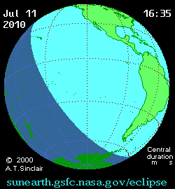
Solar eclipse July 11, 2010 - a total solar eclipse of 146 saros , which could be observed in French Polynesia , on Easter Island , in the Pacific Ocean , as well as in southern Chile and Argentina . Private eclipse phases were visible in the southern Pacific , Oceania , and partly in South America .
| Solar eclipse July 11, 2010 | |||||||
|---|---|---|---|---|---|---|---|
 Solar eclipse July 11, 2010 | |||||||
| Classification | |||||||
| Type of | Full | ||||||
| Saros | 146 (27 of 76) | ||||||
| Gamma | -0.6788 | ||||||
| Moon month | 130 | ||||||
| date of | July 11, 2010 | ||||||
| Territories | Oceania , Pacific Ocean , South America | ||||||
| Maximum phase | |||||||
| Value | 1.0580 | ||||||
| Duration | 5 minutes. 20 sec | ||||||
| Shadow width | 259 km. | ||||||
| Territory | Pacific Ocean | ||||||
| Time | 19:34:38 UTC | ||||||
| Coordinates | |||||||
| Moonlight passage | |||||||
| Start | from 17:09:41 UTC | ||||||
| Full phases | from 18:15:15 UTC | ||||||
| The ending | at 21:57:16 UTC | ||||||
| Duration | 4 hours 48 minutes | ||||||
| Eclipse photo | |||||||
| Total Solar Eclipses | |||||||
| |||||||
Gallery
Eclipse in Oceania
The path traveled by the moon shadow on a map of the Earth
Links
- Wikimedia Commons has media related to Solar Eclipse July 11, 2010
- page on the NASA website about the total solar eclipse July 11, 2010
- Interactive map of total solar eclipse July 11, 2010 with the circumstances of the phenomenon for this point
- Eclipsera: total solar eclipse July 11, 2010