Kırşehir ( tur . Kirşehir ) - silt in the central part of Turkey .
| Silt | |
| Karshehir | |
|---|---|
| tour. Kirşehir | |
| A country | Turkey |
| Included in | Central Anatolia |
| Includes | 7 districts |
| Adm. center | Karshehir |
| History and Geography | |
| Area | 6,434 km² (52nd place ) |
| Timezone | UTC + 2, in summer UTC + 3 |
| Population | |
| Population | 253,239 people ( 2009 ) ( 67th place ) |
| Density | 39.36 people / km² (64th place) |
| Digital identifiers | |
| ISO 3166-2 Code | TR-40 |
| Telephone code | +90 386 |
| Postal codes | |
| Auto Code numbers | 40 |
| Official site | |
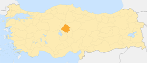 | |
The administrative center is the city of Karshehir .
Geography
Il Kırşehir borders on Kırıkkale silts in the north, Yozgat in the northeast, Nevsehir in the southeast and Aksaray in the south and Ankara in the west.
Administrative Division
Il Kırşehir is divided into 7 districts:
- Akçakent
- Akpınar
- Boztepe
- Chichekdag (Çiçekdağı)
- Kaman
- Kırshir (Kırşehir)
- Mujur (Mucur)
Sanjak Kırşehir (1912)
| Sanjak | Kaz | Muslims | Greeks | Armenians | Total number |
| Karshehir | Karshehir | 45.565 | 717 | 123 | 46,405 |
| Medjidie | 10,178 | - | - | 10,178 | |
| Keskin | 40,589 | - | 223 | 40,812 | |
| Avanos | 20,667 | - | - | 20,667 | |
| Total: | 116,999 | 717 | 346 | 118,062 |
Source: George Sotiriadis: An Ethnological Map Illustrating Hellenism, 1918