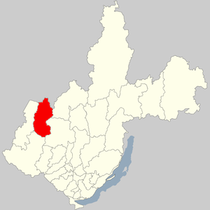
Chunsky district - administrative-territorial formation ( district ) and municipal formation ( municipal district ) in the Irkutsk region of Russia .
| district [1] / municipal region [2] | |||||
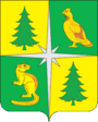
| Chunsky District | |||||
|---|---|---|---|---|---|
| |||||
| A country | Russia | ||||
| Included in | Irkutsk region | ||||
| Adm. Centre | town. Chunsky | ||||
| District mayor | Tyumentsev Valery Grigorievich | ||||
| History and Geography | |||||
| Date of formation | December 12, 1953 | ||||
| Square | 25756.81 [3] km² | ||||
| Timezone | MSK + 5 | ||||
| Population | |||||
| Population | ↘ 33,239 [4] people ( 2017 ) (1.39%) | ||||
| Density | 1.29 people / km² | ||||
| Nationalities | Russians, Tatars, Ukrainians | ||||
| Denominations | Orthodox | ||||
| Official language | Russian | ||||
 | |||||

The administrative center is the urban-type settlement Chunsky .
Geography
Chunsky district is located between 55 and 58 degrees north latitude and 98 and 110 degrees east longitude. It borders on the Krasnoyarsk Territory in the north, Ust-Ilimsky in the northeast, Nizhneudinsky in the south, and the Taishet districts of the Irkutsk region in the southwest.
The area is 85 km south from the Trans-Siberian Railway and 295 km north. The distance from the regional center, the village of Chunsky, to the city of Irkutsk is 811 km (in a straight line - 605 km). The territory of the district is stretched from north to south, from the west to east passes the Taishet - Lena railway ( BAM , the construction was carried out by the forces of the Ozerlag prisoners in 1938-1958).
- Territory - 2579 thousand ha
- The population is 46.9 thousand people.
- Municipalities, rural settlements - 13
- Settlements - 39
- Geographic conditions
The relief of the area is elevated and is represented by ridges of hills with smooth and rounded peaks. The climate is sharply continental (temperature in January −19 ° C, in July + 18 ° C; the average annual rainfall is 407.7 mm, the number of days with snow cover 176, the duration of the frost-free period is 70-80 days). Soils are podzolic, sod-podzolic, sod-forest, permafrost-meadow.
The district is located in the taiga zone, 93 percent of the total area (2,439,722 ha) is occupied under the forest. Pine and larch prevail in the forests, less commonly cedar, spruce, and fir. The animal kingdom is rich enough (bear, sable, squirrel, ermine, columns, otter, badger, hare, fox, wolf, elk, goat, etc.). A lot of useful and medicinal herbs, mushrooms and berries. Minerals are represented by clay, sand, rubble stone and rubble, gravel and sand mixture.
The main river of the Chunsky district is the Chun (Uda), its total length is 1125 km. The river is rapids, along the channel there are many sheer cliffs, large rapids - Tyumenets, Raven, Ziker Falls is widely known (water falls in steps from a height of 20 meters). The riverbed is winding, complicated by channels and elders, numerous islands and braids. The width of the river is 300-400 meters, the depth is 2.3 meters. Large tributaries - Modyshevo, Barmo, Deshima, Andocha, Parenda, Brocumka, Chuksha. Chuna, merging with Biryusa, forms the Taseeva River, which flows into the Angara.
In early July, during snowmelt in the East Sayan Mountains (where the Uda River originates), there are often severe floods (the latter was noted on July 5, 1996, when the water rose four meters in four days and there was a danger to the railway bridge. Priudinsk, dachas suffered in Lesogorsk, about a thousand hectares of sown fields were flooded).
- Resources
The leading branch of the regional economy is forestry .
Two forestries are engaged in forestry - Baersky and Chunsky.
The total area of forest stands is 2208.3 thousand ha, of which the forests of the W group are 1607.8 thousand ha.
The total stock of wood is 410.1 million cubic meters, including coniferous - 322.8 million cubic meters, the stock of forests of group III - 315.3 million cubic meters, of which coniferous - 253.9 million cubic meters.
The area also has manifestations of diamonds, iron, gold, brown coal.
History
On the basis of the decree of the Presidium of the Supreme Council of the RSFSR of 12.12.1953, the Chunsky district with the administrative center in the settlement of Oktyabrsky was formed from a part of the territories of the Alzamay, Shitkinsky and Tanguisky districts (from 23.12.1955 it was classified as a working village).
The basis for the development of the region is the harvesting and processing of wood. From 1.09.1946, the first-born of logging enterprises, Chunsky LZK, traces its history. In 1949, Novochunsky, Bayandaevsky and Frunzensky timber enterprises appeared. Since 1954, the construction of the Lesogorsky LDK began. In 1948–2000, the Novochunsky Kirzavod operated, whose products were supplied to other areas of the Irkutsk Region (Bratsk, Ust-Ilimsk, Zheleznogorsk).
In the early 30s, collective farms appeared on the territory of the district; they were in all large villages and villages with a long history - Balturine, Vydrina, Chervyanka, Gankin, Takhtamai, Zakharovka, Mironovka, Nevanka, Novochunk, etc. In 1969, at the base collective farms formed two state farms - "Chunsky" and "October". In 1955-1985, wastelands were actively explored, swamps were drained, and small forests were cut down under arable land. In total, 14,665 ha of arable land, 4,192 ha of hayfields, 4,238 ha of pastures were assigned to state farms, more than 13 thousand ha were sown annually (8,000 hectares were occupied under grain crops).
In connection with the enlargement of the districts of the region, the Chunsky district was liquidated from 01/01/1963: five village councils went to the Bratsk region, and village councils of the workers' villages of Lesogorsk, Oktyabrsky, Chunsky and four village councils went to the Taishet district (Shitkinsky district in 1960 entered to the Taishet district).
By decree of the Presidium of the Supreme Council of the RSFSR of 08/06/1964, the Chunsky district was formed as part of the river. Oktyabrsky settlement (administrative center), Lesogorsk, Chunsky and village councils: Bayersky, Novochunsky, Tareysky, Targiz. By decree of the PVS of the RSFSR of January 12, 1965, the center of the district was moved to the river Chunsky settlement (the district included three village and nine village councils). At the XXIII Congress of the CPSU (04/08/1966), a decision was made to create the Chunsky timber industrial complex, which served as a powerful impetus to industrial and housing construction in the town. Chunsky. From 1966 to 1986, the LZK team was headed by P.G. Tverdokhleb, a talented leader who put a lot of effort into turning Chuna, a rampart and shield room, into a modern, comfortable village with developed infrastructure.
Improving living conditions contributed to the fact that workers increased labor productivity by exceeding socialist obligations. The labor collectives of the district repeatedly received the rolling Red Banners of the Ministry of Forestry and Woodworking, the Regional Committee and the Central Committee of the CPSU. Hundreds of production leaders were awarded high government awards, and two - V.N. Baranov (1966) and V.I. Ryzhkov (1986) were awarded the title Hero of Socialist Labor.
The indigenous population of the region was Evenki (Tungus), but from the second half of the 17th century, the exploration of Eastern Siberia by Russian explorers began. Bratsky (1631) and Nizhneudinsky fortresses (1648), the village of Shitkino (1726) were founded here.
In 1859, the List of populated areas of the Yenisei province, published by the central committee of the Ministry of Internal Affairs, already included the villages of Chervyanka (361 people), Balturino (173 people), Gankino (110 people), Berezovo (114 people), Chunskaya (village Novochunka) - 138 people, Takhtamay (142 people), Bunbuy (116 people), Village (126 people), Nevanka (176 people), Vydrino (208 people). There are no exact data on the founding of these villages, but the high number of residents suggests that these settlements are old-timers.
In the 1950s, as part of the decree of the Council of Ministers of the USSR of January 17, 1955, "On the Recruitment of Workers in the People's Republic of China for Participation in Communist Construction and Labor Training in the USSR," Chinese workers worked at enterprises and construction sites in the region [5] .
For many decades, the blind junction of the Yenisei and Irkutsk provinces served as an ideal place for the exile of “dissenters”. However, significant changes in the national composition of the population occurred only in the post-war years, when the Balts, Moldovans, Western Ukrainians, etc., were evicted from the western regions of the USSR to develop the forest resources of the Chun taiga. The construction of the second BAM paths (since 1974) also contributed to population growth. in the Chunsky area.
Population
| Population | ||||||
|---|---|---|---|---|---|---|
| 2002 [6] | 2009 [7] | 2010 [8] | 2011 [9] | 2012 [9] | 2013 [10] | 2014 [11] |
| 41,829 | ↘ 39 554 | ↘ 36 516 | ↘ 36 311 | ↘ 35 755 | ↘ 35 120 | ↘ 34,480 |
| 2015 [12] | 2016 [13] | 2017 [4] | ||||
| ↘ 33 977 | ↘ 33 641 | ↘ 33 239 | ||||
- Urbanization
In urban conditions (the working villages of Lesogorsk , Oktyabrsky and Chunsky ) 72.41% of the population of the region live.
Municipal Territory
There are 39 settlements in the Chunsky district as part of three urban and eight rural settlements:
| No. | Urban and rural settlements | Administrative center | amount populated points | Population | Square, Km 2 |
|---|---|---|---|---|---|
| one | Lesogorsk municipality | working village Lesogorsk | 3 | ↘ 5648 [4] | 172.99 [3] |
| 2 | October Municipal Formation | working village Oktyabrsky | 2 | ↘ 5262 [4] | 345.50 [3] |
| 3 | Chunsky municipality | working village Chunsky | 2 | ↘ 14 135 [4] | 8362.44 [3] |
| four | Balturinsk Municipality | Novobalturina village | four | ↘ 527 [4] | 946.60 [3] |
| five | Bunbuy Municipality | Bunbuy village | four | ↘ 415 [4] | 3712.04 [3] |
| 6 | Vesyolovo municipality | Cheerful village | 6 | ↘ 1829 [4] | 2226.77 [3] |
| 7 | Kamensky Municipality | Kamensk village | four | ↘ 1231 [4] | 870.00 [3] |
| eight | Mukhinsky municipality | Mukhino village | 3 | ↘ 288 [4] | 139.00 [3] |
| 9 | Novochun Municipality | Novochunka village | 3 | ↘ 2063 [4] | 3082,00 [3] |
| ten | Targiz municipality | Targiz village | 7 | ↘ 1595 [4] | 3410.60 [3] |
| eleven | Chervyansk Municipality | Chervyanka village | one | ↘ 246 [4] | 2488.87 [3] |
| List of settlements of the district | ||||
|---|---|---|---|---|
| No. | Locality | Type of | Population | Municipality |
| one | Baer | village | ↘ 38 [9] | Mukhinsky municipality |
| 2 | Balturino | village | ↘ 83 [9] | Balturinsk Municipality |
| 3 | Bayanda | village | ↘ 251 [9] | Lesogorsk municipality |
| four | Bidoga | village | ↘ 444 [9] | Lesogorsk municipality |
| five | Buonbuy | village | ↘ 393 [9] | Bunbuy Municipality |
| 6 | Happy | village | ↘ 1403 [9] | Vesyolovo municipality |
| 7 | Vydrino | village | ↘ 64 [9] | Bunbuy Municipality |
| eight | Gankina | village | ↘ 12 [9] | Bunbuy Municipality |
| 9 | Yelan | village | ↗ 61 [9] | Targiz municipality |
| ten | Factory | village | ↘ 253 [9] | Novochun Municipality |
| eleven | Zaharovka | village | ↗ 27 [9] | Targiz municipality |
| 12 | Izykan | village | ↗ 586 [9] | Targiz municipality |
| 13 | Kamensk | village | ↘ 656 [9] | Kamensky Municipality |
| 14 | Cedar | village | ↘ 47 [9] | Kamensky Municipality |
| 15 | Kulish | village | ↘ 172 [9] | Vesyolovo municipality |
| sixteen | Lesogorsk | working village | ↘ 4982 [4] | Lesogorsk municipality |
| 17 | Mironovo | village | → 1 [9] | Chunsky municipality |
| 18 | Mukhino | village | ↗ 156 [9] | Mukhinsky municipality |
| nineteen | Upland | village | → 0 [9] | Kamensky Municipality |
| 20 | Nevanka | village | ↘ 2 [9] | Bunbuy Municipality |
| 21 | Novobalturin | village | ↘ 418 [9] | Balturinsk Municipality |
| 22 | Newbie | village | → 17 [9] | Balturinsk Municipality |
| 23 | Newbie | village | ↘ 1717 [9] | Novochun Municipality |
| 24 | Outskirts | village | ↘ 28 [9] | Vesyolovo municipality |
| 25 | October | working village | ↘ 4952 [4] | October Municipal Formation |
| 26 | Parenda | village | ↘ 347 [9] | Vesyolovo municipality |
| 27 | Brocade | village | ↘ 696 [9] | Kamensky Municipality |
| 28 | Pioneer | village | ↘ 400 [9] | Novochun Municipality |
| 29th | Pitaeva | village | → 15 [9] | Vesyolovo municipality |
| thirty | Priudinsk | village | ↘ 132 [9] | Mukhinsky municipality |
| 31 | Sosnovka | village | ↘ 608 [9] | Targiz municipality |
| 32 | Targiz | village | ↘ 459 [9] | Targiz municipality |
| 33 | Tarea | village | ↘ 48 [9] | Vesyolovo municipality |
| 34 | Tarea | village | → 51 [9] | Targiz municipality |
| 35 | Tahtamay | village | ↘ 101 [9] | Balturinsk Municipality |
| 36 | Honyaki | village | ↗ 310 [4] | October Municipality |
| 37 | Worm | village | ↘ 246 [4] | Chervyansk Municipality |
| 38 | Chuksha | village | ↘ 25 [9] | Targiz municipality |
| 39 | Chunsky | working village, administrative center | ↘ 14 135 [4] | Chunsky municipality |
Social Sphere
In the area are:
- 32 full-time secondary schools (10 elementary, 6 basic, 16 secondary);
- boarding school;
- evening (shift) comprehensive school;
- 22 preschool educational institutions;
- district house of children's creativity;
In 2003, in the district’s day schools (including a boarding school), 6,701 students were enrolled in 408 classrooms.
Medical assistance to the population is provided in the central district hospital, 2 district hospitals, 2 rural outpatient clinics and 16 feldsher-obstetric centers.
Notes
- ↑ from the point of view of the administrative-territorial structure
- ↑ from the point of view of the municipal structure
- ↑ 1 2 3 4 5 6 7 8 9 10 11 12 Irkutsk region. The total land area of the municipality
- ↑ 1 2 3 4 5 6 7 8 9 10 11 12 13 14 15 16 17 18 The population of the Russian Federation by municipalities as of January 1, 2017 (July 31, 2017). Date of treatment July 31, 2017. Archived July 31, 2017.
- ↑ Chinese labor migration in Russia. Little-known pages of history. V. Datsyshen. Published in the journal "Problems of the Far East", 2008, No. 5, p. 99-104
- ↑ 2002 All-Russian Population Census. Tom. 1, table 4. The population of Russia, federal districts, constituent entities of the Russian Federation, regions, urban settlements, rural settlements - district centers and rural settlements with a population of 3 thousand or more . Archived February 3, 2012.
- ↑ The number of permanent population of the Russian Federation by cities, urban-type settlements and districts as of January 1, 2009 . Date of treatment January 2, 2014. Archived January 2, 2014.
- ↑ Results of the 2010 All-Russian Population Census for the Irkutsk Region . Date of treatment September 23, 2013. Archived September 23, 2013.
- ↑ 1 2 3 4 5 6 7 8 9 10 11 12 13 14 15 16 17 18 19 20 21 22 23 24 25 26 27 28 29 30 31 32 33 34 35 36 Population by municipalities as of January 1, 2012: stat. bull. Irkutskstat. - Irkutsk, 2012 .-- 81 p. . Date of treatment September 24, 2016. Archived September 24, 2016.
- ↑ The population of the Russian Federation by municipalities as of January 1, 2013. - M.: Federal State Statistics Service of Rosstat, 2013. - 528 p. (Table 33. The population of urban districts, municipalities, urban and rural settlements, urban settlements, rural settlements) . Date of treatment November 16, 2013. Archived November 16, 2013.
- ↑ Table 33. The population of the Russian Federation by municipalities as of January 1, 2014 . Date of treatment August 2, 2014. Archived on August 2, 2014.
- ↑ The population of the Russian Federation by municipalities as of January 1, 2015 . Date of treatment August 6, 2015. Archived on August 6, 2015.
- ↑ Population of the Russian Federation by municipalities as of January 1, 2016