Russian [1] (previously also Kazakevich’s island [2] ) - an island in the Peter the Great Bay of the Sea of Japan , located one kilometer from the city of Vladivostok and is part of the Vladivostok municipal district [3] [4] . Included in the archipelago of Empress Eugenia .
| Russian | |
|---|---|
 | |
| Characteristics | |
| Area | 97.6 km² |
| Highest point | 291.2 m |
| Population | 4703 people (2010) |
| Population density | 48.19 people / km² |
| Location | |
| Archipelago | Archipelago of Empress Eugenia |
| Water area | Japanese Sea |
| A country |
|
| The subject of the Russian Federation | Primorsky Krai |
| Area | Vladivostok |


Content
- 1 Geography
- 1.1 Geographical location
- 1.2 Relief
- 1.3 Hydrography
- 1.4 Climate
- 1.5 Vegetation
- 2 Demographics
- 3 History
- 3.1 The occupation of the Russian Far East by the troops of Britain, the USA and Japan
- 3.2 Soviet time
- 3.3 Post-Soviet time
- 4 Toponymy
- 5 Science and education
- 6 Transport connection
- 7 Economic Perspectives
- 8 Russian island in modern culture
- 9 Interesting Facts
- 10 notes
- 11 Links
Geography
The island is 97.6 km², length is about 18 km, width is about 13 km.
Several bays protrude into the island, the largest of which is Novik Bay . Stretching out a long narrow sleeve from the northwest to the southeast for more than 12 km, it remains its main internal transport artery [ where? ] . This bay divides the island into two unequal parts:
- southwest (larger)
- northeastern (narrower), called the Saperny Peninsula .
Geographical position
Russky Island is located in Peter the Great Bay in the Sea of Japan, south of Vladivostok (the smallest distance between the continental part of the city and the island is 800 meters). From the Muravyov-Amursky peninsula , where the bulk of Vladivostok is located, Russky is separated by the Eastern Bosphorus . From the west, the island is washed by the waters of the Amur Bay , and from the south and east - the Ussuri . In the southwest, the Stark Strait is separated from the next island of the archipelago - Popova Island .
Relief
The relief is mountainous, characteristic of the south of Primorye . On the island there are 47 peaks of various heights, called hills . The highest of them are located in the central part of the island: Russkaya (291.2 m), Main (279.8 m) and Central (254.9 m).
The coastline is very rugged. Its length is 123 km. Far inland, the bays of Novik, Voivod and Rynda protrude. All of them are located on the west coast of the island and belong to the water area of the Amur Bay. There are also many bays on the north and south coasts, but they are more open. The east coast faces the open sea and is the least indented. On the island abrasive (rocky, steep) coasts are widespread. Steep coastal slopes with narrow beaches along them are found everywhere, even in deep inland bays. Low-lying sloping shores can be found only at the tops of bays and bays. Near the Russian coast is a number of small uninhabited islands and islets. Dams were strewn to some of them, and Elena Island , on the contrary, was separated from the Russky Canal.
Hydrography
On the island, there are 17 streams with a length of more than 1 km, 7 streams of more than 2 km and one river - the Russkaya (Voevodikha), with a length of more than 5 km. There are lakes of fresh water on the island, some of them are the result of human activities: the technical lake of the Voroshilov battery, small reservoirs in Truda Bay and on the Foothills, former quarries of a brick factory on the Babkin Peninsula and sand production near Ostrovnaya Bay. The largest lakes of natural origin are Gluzdovsky (Akhlestysheva) with an area of 5 hectares and Lime (in the people - “Parisovsky”, by the name of the nearby bay). Wetlands are found in the lower reaches of the Russkaya River, as well as in the estuarine parts of some streams.
Climate
The microclimate of the northwestern side differs from the southeastern one facing the open sea. During the summer monsoon, the southeastern, windward side of the island is more often covered with fog, drizzle is denser and slightly colder than on the northwestern side. Water in the bays of Novik, Rynda and Voevoda warms up faster than in the open part of the Ussuri Bay, which washes the east of the island. In winter, the first ice first appears at the top of Novik Bay (early December), then in Voivode and Rynda. The winds of the Asian anticyclone drive the ice to the northwest coast of the Muravyov-Amursky peninsula and the Empress Eugenia archipelago, along which fast ice is formed. During its greatest distribution along the coast of the Russian island, it stretches from the village of Pospelovo to the Stark Strait. In addition, thin ice forms north of the islands of Engelm and Lavrov and in Novy Dzhigit Bay. The coast of the island is completely free of ice by the end of March - mid-April.
Vegetation
The island is dominated by forests, large areas of which are derivatives of black fir-deciduous forests. Currently, black fir and Korean cedar are found only in culture, while most of the island is covered with dense broad-leaved forest. Oak prevails in the stand, but other species are also widespread: linden (3 species), maple (6 species), ash (3 species), Sakhalin cherry (Sargent) and Maksimovich, hornbeam . Representatives of the southern flora are often found: Amur velvet , Manchurian walnut , seven-bladed kalopanaks , Japanese alder , etc. In the undergrowth grow: small-leaved mock -up , early weigela , rhododendron , Korean abelia , honeysuckle, hazel, spruce, rosehip, and hawthorn. many vines. Among them: actinidia of three types, grapes , lemongrass , wood-pliers and whip-shaped and round-leaved , Nippon dioscorea [5] ...
Demographics
The population is 4,703 [6] inhabitants (2010). After the FEFU campus was built, the population of the island increased significantly - 10.5 thousand people permanently live on the campus [7] .
- 1860s - ▲ 235 inhabitants
- 1895 - ▲ 3,000 inhabitants.
- 1908 - ▲ 25,000 inhabitants.
- 1959 - ▼ 6 093 inhabitants.
- 1970 - ▼ 5,449 inhabitants.
- 1979 - ▲ 5,775 inhabitants.
- 1989 - ▲ 6,020 inhabitants.
- 1994 - ▼ 5,600 inhabitants.
- 2002 - ▼ 5 204 inhabitants.
- 2010 - ▲ 5,360 inhabitants.
History
The name of the island was given by the Governor General of Eastern Siberia Count N. N. Muravyov-Amursky . The island officially became part of Russia in the second half of the 19th century. According to one version, the island was named Russian in honor of Russia. According to another, the name of the island arose later and simply duplicates the name of the Russian Mountain (former Russian ), so named in honor of one of the crew members of the first Russian explorers of the island.
In 1859, the first map was published in Russia, on which Russian was first shown. True, not all, but only its western and northern shores.
A full survey of the island was made by the expedition of Lieutenant Colonel of the Naval Naval Corps V. Babkin in 1862 during the inventory of Peter the Great Bay , after which a map was published in 1865 on which the island was completely marked and named Kazakevich Island by the name of the first military governor of the Primorsky Region of the Admiral P. Kazakevich . Both names were used, but after World War II only one was assigned to the island - Russian [2] .
In the 1860s, when cutting land to create a specific department, the head of his Siberian branch, G. Furugelm, recognized the Russian island, along with other areas, as the most suitable for organizing agriculture. Despite this, in 1867 Russian was not included in the number of lands of the specific department.
The development of the coastal defense of the island and the deployment of troops here led to the fact that the number of civilians began to increase on it. Some of them took up gardening, providing vegetables not only to the island, but also to Vladivostok. Others joined in serving the needs of the military. At this time, the number of civilians on the island reached 236 people, and by 1895 it increased to 3 thousand. The provision of firewood to the residents of Vladivostok became an additional business for local residents, and the breeder M. Fedorov rented a Druzhok screw boat and arranged regular flights to the city.
In 1890, under the leadership of lieutenant colonel K. Chernokhnizhnikov, a project was developed to build the Vladivostok fortress , which first draws attention to the geographical advantages of the Russian island for the defense of Vladivostok. In particular, according to the plan, it was necessary to build a fort on Russkaya Mountain and dig a canal through the isthmus in the north of the island.
The construction in 1898 of a canal connecting the Eastern Bosphorus Strait with Novik Bay, where submarines were based during the Russo-Japanese war, was of particular importance for the development of the Russian island. Artificially arisen at the same time, the island was named after Elena .
In 1895-1896, when intensive construction began on the island, in connection with which a new population growth was indicated, it was decided to erect the temple of the Vladivostok Fortress Infantry Regiment. The construction of the church was carried out at the expense of donations, but the main contribution was made by the contractor of the military department and the merchant of the first guild M. Suvorov . The church for 400 believers was built of wood and was completed in 1897, as well as consecrated in the presence of the governor of the Primorsky region. In 1909, a cemetery was opened, in 1916 - a post office.
After the Russo-Japanese War of 1904-1905, the first house churches appeared on the island, and then the stone temples of the Siberian Rifle Regiments. Nowadays only one building of the regimental church in the village of Podogod is preserved.
From 1899 to 1914, during the period of aggravation of relations with Japan , active construction of the Vladivostok fortress began on the island. In this regard, a cableway even appeared in Russky, which ensured the delivery of goods to construction sites. This period left a special mark on the map of the island. The scale of construction was simply unprecedented. By 1915, 6 forts and 27 coastal batteries, gunpowder cellars and ammunition depots, a marina for ships, a mine-sighting (torpedo) station, 4 telephone exchanges, caponiers and half-capers, artillery workshops, military camps, piers, a brick factory , powerful radio stations, laid tens of kilometers of cables and communication lines, equipped with powder and tunnel cellars. Of the 16 forts of the fortress, 6 were located on the island, of the 50 coastal batteries, 27.
The population of the island by 1908 reached 25 thousand people. The construction of the fortress was finally completed by 1922, when Japanese troops agreed to leave Primorye under an agreement with the Soviet government, provided that the fortress was closed.
Also in 1908, the first observation station in Russia was built on the island, reliably protecting Vladivostok from plague, cholera and other diseases [8] .
In the same year, Grand Duke Sergei Mikhailovich , who was in Russian, called the Vladivostok fortress the most prepared, and one of the batteries was called the Grand Duke. In 1913-1914, the hero of the Japanese war, General Kornilov , served in the "exile" on the Russian island. The famous [ what? ] the entire country disciplinary battalion.
Also in 1913-1914, the future pilot and Soviet aircraft designer Konstantin Kalinin served on the island.
Occupation of the Russian Far East by British, US, and Japanese forces
On Russky Island, a concentration camp and base of the occupying forces of Britain and the United States were located . The military base was served by Chinese and Korean workers, imported by the British as cheap labor. The base existed on the Russian island until October 1922 [9] .
In 1920, there was a colony of 900 Petersburg children in Russky, who in 1918-1920, by the will of circumstances, made a complete round-the-world trip, practically unknown to the general public until 2005. [10]
Soviet time
For a long time, the island had the status of a closed territory , here were located the fortifications of the Vladivostok fortress and many military units, which today are almost all destroyed. In Soviet times, several military towns were located on the island.
The island was a major training base for the entire navy of the USSR, there were a number of training units: radio engineering school (RTSH), (military unit 70024), school of mechanics, weapon school, communication school (military unit 69268), midshipman school (in / h 95125).
On the shore of Ostrovnaya Bay there was a part of the special forces of the Navy - military unit 59190 (42nd Special Purpose Marine Reconnaissance Point).
Russky Island, along with Popova Island , is a favorite vacation spot for residents of Vladivostok. There are no industrial, construction and other enterprises on the island.
During the Great Patriotic War, thousands of sailors and officers who served on the island participated in battles with the Nazi invaders and Japanese militarists. The titles of Hero of the Soviet Union were awarded to F. I. Vyaltsev and M. P. Panarin (school of communication); V. G. Zaitsev (anti-aircraft division); M.P. Krygin (special department) and others.
In the Soviet period, people known in the navy and in the country at different times served on the island: Captain V.I. Kuroyedov (from 1997 to 2005 - Commander-in-Chief of the Russian Navy), chief of staff of the OVR brigade, rear admiral, Honorary Citizen of the city Vladivostok, Yu. N. Geraskin, 2nd-class captain V. D. Fedorov (from 2001 to 2007 - commander of the Pacific Fleet), playwright and writer E. V. Grishkovets .
Post-Soviet Time
After the collapse of the USSR on the island, on the territory of the former disciplinary company of the Pacific Fleet, which later grew into a disciplinary battalion (military unit 81233), located on the shore of Voevoda Bay, the White Swan recreation complex was created.
In 2002, the St. Seraphim Monastery was founded on the island.
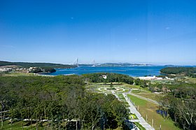
In the summer of 2012, a cable-stayed bridge was built that connected the island with the mainland of Vladivostok. Also on the island is the Far Eastern Federal University , built on the territory of the former military unit 95125 (105 school of midshipmen and warrant officers of the Pacific Fleet). In 2016, the Primorsky Aquarium was opened on Russky Island. In November 2018, the construction of the museum and theater complex began, which will include a branch of the Central Music School at the Moscow State Conservatory named after Tchaikovsky , a branch of the Academy of Ballet. Vaganova , a secondary school and a boarding school for children who will study music and ballet, as well as residential buildings for employees of these institutions [11] .
Toponymy
The toponymy of the island took shape over seven decades and has already become its history. It reflected the period of discovery and exploration of these lands, when the names of officers of the Russian fleet were mapped: V. M. Babkin, M. A. Akhlestyshev, A. P. Novosilsky , N. S. Vasiliev, G. G. Tobizin , А. А. Рогозина и других, названия кораблей: Новик, Рында, Воевода, Боярин, Джигит.
Позже на карте появились имена учёных: А. И. Черского, К. И. Богдановича, Ф. Н. Чернышёва, П. А. Кошелева; моряков-гидрографов: А. П. Вятлина, В. Р. Гацкевича, Л. П. Елагина, М. Е. Жданко, В. И. Филиповского, Н. П. Дарагана; топографов К. С. Старицкого, Н. А. Иванцова, Н. С. Васильева, В. Половцева; известных людей, чья жизнь была тесно связана с городом, портом и крепостью: городского головы Владивостока В. П. Маргаритова, гласного Владивостокской городской думы В. Ф. Михайловского, главного командира порта Ф. П. Энгельма, главного контролёра по постройке крепостных сооружений Н. М. Соловьёва, начальника инженеров Владивостокской крепости А. П. Шошина, начальника Тихоокеанской эскадры В. П. Шмидта , главного доктора Владивостокского морского госпиталя А. Д. Рончевского, начальника обороны крепости Порт-Артур Р. И. Кондратенко, участника обороны Порт-Артура И. И. Ислямова; а также поэтов Я. П. Полонского и А. А. Фета.
В 1912 году впервые почти все географические названия острова, существовавшие на тот момент, были нанесены на карту П. В. Виттенбургом. В 1996 году военный гидрограф профессор А. И. Груздев уточнил и систематизировал происхождение и время появления топонимов, подготовил богатый биографический материал.
Наука и образование
К саммиту АТЭС 2012 года в бухте Аякс на острове Русский был построен кампус Дальневосточного федерального университета . Учебный процесс в нём начался 1 сентября 2013 года. Общая площадь кампуса — 800 тыс. м², общая площадь застройки — 650 тыс. м². На территории кампуса оборудовано 5503 комнаты для проживания студентов. В состав кампуса входят гостиничные комплексы, общежития для студентов, студенческий центр площадью 40 тыс. м², собственный спортивный стадион и фитнес-центр, учебные центры, необходимые объекты социально-бытовой инфраструктуры [7] .
На базе университета запущен технопарк «Русский» [12] .
6 сентября 2016 года на Русском острове, на полуострове Житкова, открыт Приморский океанариум (научно-образовательный комплекс ДВО РАН ) .
Транспортное сообщение
До 2012 года между городом и островом существовала регулярная паромная переправа (зимой возникали проблемы). Проект моста на остров утверждён в 2007 году. Стройка стартовала 3 сентября 2008 года, и уже в 2012 году мост на Русский остров был построен. Глубокой ночью 12 апреля 2012 года рабочие завершили подъём последней, замковой панели. Согласно графику строительства, мост был сдан в эксплуатацию 2 июля 2012 года [13] . Мост возглавил список самых длинных вантовых мостов в мире. Его открытие позволило сократить время в пути из центра Владивостока до острова Русского с трёх часов до 20 минут. Впоследствии из-за открытия моста паромная переправа между островом и материком была закрыта, но в 2017 году её возобновили по просьбе жителей отдалённых посёлков острова, в частности, посёлка Подножье, который отделяет от моста 50 км [14] .
Экономические перспективы
В 2005 году администрация Приморского края разработала инвестиционный проект «Развитие острова Русский». По проекту на острове планировалось разместить комплекс производств в сфере био- и информационных технологий, университетский комплекс мирового уровня, межрегиональный медицинский центр.
Правительство РФ в 2006 году одобрило строительство моста от Владивостока до Русского. Кроме того, программой было предусмотрено строительство спортивно-рекреационных, музейных и гостиничных комплексов, жилого фонда. Как отмечало агентство ИТАР-ТАСС , в перспективе именно Русский остров станет точкой роста для всего Дальневосточного региона , крупным центром международного сотрудничества со странами Азиатско-Тихоокеанского региона .
2 сентября 2012 года на Русском открылся саммит организации Азиатско-Тихоокеанского экономического сотрудничества (АТЭС). В связи с этим на острове было развёрнуто крупное строительство. Для проведения саммита на Сапёрном полуострове был выстроен крупный международный деловой центр (часть кампуса ДВФУ ).
Постановлением правительства РФ с 31 марта 2010 на территории Русского острова создана туристско-рекреационная особая экономическая зона [15] .
В июне 2017 года премьер-министр России Дмитрий Медведев утвердил концепцию развития острова Русского, который, по планам, должен был стать площадкой для интеграции РФ в Азиатско-Тихоокеанский регион [16] [17] .
27 июля 2018 года Совет Федерации одобрил законы о создании специальных административных районов (САР) на Октябрьском острове в Калининграде и на острове Русский в Приморье, которые станут офшорными территориями с особыми финансовыми условиями [18] .
Запланировано строительство Военно-патриотического парка культуры и отдыха Восточного военного округа «Патриот» [19] .
Russian island in modern culture
- Eugene Grishkovets in the play " How I ate a dog " talks about his service on the Russian island.
- Sound-art - Russian Island and Vladivostok
- In 1987, part of the movie “ Moonzund ” based on the novel by Valentin Pikul was shot on the Voroshilov artillery battery that was in operation then .
- The island is dedicated to the song of the Marlins group entitled: “Labyrinths of the Russian Island”
Interesting Facts
- March 3, 1919 in the American Red Cross hospital in Russian, the famous Norwegian natural scientist Johan Koren died of the “ Spanish woman ”.
- On the northeast coast of the island was a compact Korean settlement. In the 1930s and 1940s, all Koreans were evicted from the Russian. However, the names “Russia” and “Korea” still remain in local toponymy to denote the different parts of the same village of Ajax.
- From the end of 1930 to the end of 1990, the Voroshilov battery (No. 981) was armed with guns of the largest caliber in the USSR - 305 mm. Two medium three-gun towers were removed from the battleship Poltava , built after the Russo-Japanese War of 1904-1905, and were installed on Russky Island, and two more in Sevastopol (battery number 30).
- Nanosella russica (lat.) - a species of beetles of the genus Nanosella from the family of percoptera ( Ptiliidae ) was named after the Russian island. One of the smallest representatives of the coleoptera squad in the Russian fauna [20] .
Notes
- ↑ In the encyclopedic editions, the heading of the corresponding article consistently uses the phrase Russian Island , consisting of two words:
- Russian Island // Brockhaus and Efron Encyclopedic Dictionary : in 86 volumes (82 volumes and 4 additional). - SPb. , 1890-1907.
- Russian Island // Big Soviet Encyclopedia : [in 30 vol.] / Ch. ed. A.M. Prokhorov . - 3rd ed. - M .: Soviet Encyclopedia, 1969-1978.
- Russian Encyclopedic Dictionary: in 2 books. / ch. ed. A.M. Prokhorov. - M .: Great Russian Encyclopedia, 2001.
- Dictionary of modern geographical names / edited by Acad. V.M. Kotlyakova. - Yekaterinburg: U-Factoria, 2006.
- Big Encyclopedia : in 62 volumes - M .: Terra, 2006.
- Russian island . Geographical names of Russia . Institute of Geography RAS: Information Portal. Date of treatment June 27, 2015.
- Russian island // Romania - Saint-Jean-de-Luz. - M .: Big Russian Encyclopedia, 2015. - P. 66. - ( Big Russian Encyclopedia : [in 35 vols.] / Ch. Ed. Yu. S. Osipov ; 2004—2017, vol. 29). - ISBN 978-5-85270-366-8 .
- ↑ 1 2 Shchadrin B.D. Vladivostok, Russky Island , Vladivostok Fortress (June 2011). Date of treatment April 4, 2017.
- ↑ “On the administrative-territorial structure of the Primorsky Territory” (as amended on 06/05/2017), the Law of the Primorsky Territory of November 14, 2001 No. 161-KZ . docs.cntd.ru. Date of treatment November 8, 2017.
- ↑ “On the Vladivostok City District”, Law of the Primorsky Territory dated December 6, 2004 No. 179-KZ . docs.cntd.ru. Date of treatment November 8, 2017.
- ↑ Nedoluzhko V.A., Denisov N.I. Flora of vascular plants of Russky Island (Peter the Great Bay in the Sea of Japan) / Ed. ed. A.P. Dobrynin. - Vladivostok: Dalnauka, 2001 .-- S. 98. - ISBN 5-8044-0110-6 .
- ↑ Population of urban districts, municipalities, urban and rural settlements, urban settlements, rural settlements. All-Russian population census of 2010 (as of October 14, 2010). Primorsky Territory . Date of treatment August 31, 2013. Archived June 11, 2013.
- ↑ 1 2 About the University. Figures and facts . FEFU . Date accessed August 9, 2019.
- ↑ Observation station on Russky Island (February 19, 2010). Date of treatment November 8, 2017.
- ↑ Intervention during the Civil War . russianisland.ru . Date accessed August 9, 2019.
- ↑ The exhibition "Petrograd Children" opens in Primorye . RIA Novosti (June 16, 2011). Date of treatment July 2, 2012. Archived on August 5, 2012.
- ↑ Construction of the museum and theater complex in Russkoye began on a recently paved parking lot (PHOTO), Vl.ru (November 20, 2018). Circulation date May 17, 2019.
- ↑ Technopark "Russian" in Vladivostok will receive its own complex of buildings . TASS. Date of treatment March 30, 2019.
- ↑ The bridge is insured by ships . Newspaper.Ru (June 30, 2811). Date of treatment March 30, 2019.
- ↑ Sea passenger line between Russky and Vladivostok opened in test mode , PrimaMedia (September 25, 2017). Circulation date May 17, 2019.
- ↑ Decree of the Government of the Russian Federation of March 31, 2010 No. 201 “On the establishment of a tourist-recreational special economic zone” on the territory of the Russian island of the Vladivostok city district of the Primorsky Territory . pravo.gov.ru . Date accessed August 9, 2019.
- ↑ Medvedev approved the concept of Russky Island . RIA Novosti (June 5, 2017).
- ↑ Decree of the Government of the Russian Federation of May 30, 2017 No. 1134-r “On approval of the Concept of development of the Russian island” . The official Internet portal of legal information (May 30, 2017). Date of appeal October 31, 2018.
- ↑ The Federation Council approved the laws on ATS on the Russian islands in Primorye and Oktyabrsky in the Kaliningrad Region , Finmarket.ru (July 28, 2018). Date of appeal October 31, 2018.
- ↑ Order of the Government of the Russian Federation dated 03.10.2018 No. 2126-r . The official Internet portal of legal information (October 3, 2018). Date of appeal October 31, 2018.
- ↑ Polilov, AA An introduction to the Ptiliidae (Coleoptera) of Primorskiy region with descriptions of three new genera, new and little known species // Russian entomological journal. - 2008 .-- T. 17 . - S. 149–176 . - ISSN 0132-8069 .
Links
- Topographic maps
- Topographic map sheets K-52-36-G-v , K-52-36-G-g , K-52-48-A-b (inaccessible link) . Archived December 24, 2013. , K-52-48-B-a , K-52-48-B-b
- Information
- Olga Timofeeva. The most Russian island . Russian reporter (May 2008). Date of treatment September 9, 2010. Archived February 11, 2012.
- The history and geography of the island on the site of the health resort "White Swan" (Inaccessible link - history ) .
- Holy Seraphim Monastery on the website of the Vladivostok Diocese of the Russian Orthodox Church .
- Official site on the construction of a bridge on the Russian island
- Marina Koroleva . Far East - what to do with it? (Vladivostok and the Russian island) . Echo of Moscow. Date of treatment April 21, 2008. Archived February 11, 2012.
- Marina Koroleva , Olga Bychkova , Sofiko Shevardnadze . With my own eyes: Vladivostok and the Russian island . Echo of Moscow. Date of treatment July 25, 2008. Archived February 11, 2012.
- Recreation facilities on Russky Island (Vladivostok), interesting places
- Site dedicated to the Russian island