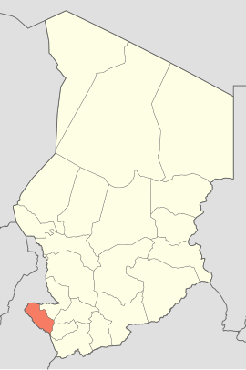
Western Mayo-Kebi ( fr. Mayo-Kebbi Ouest , Arabic. منطقة مايو كيبي الغربي ) is an administrative region in the Republic of Chad . The region received its name from the Mayo-Kebi River flowing here.
- The administrative center is the city of Pala .
- The area is 14,000 km² , the population is 569,087 people ( 2009 ).
| administrative region | |
| West Mayo-Kebi | |
|---|---|
| fr Mayo-kebbi ouest Arab. منطقة مايو كيبي الغربي | |
| A country | |
| Includes | 2 departments |
| Adm Centre | Pala |
| History and geography | |
| Square | 14,000 km² (20th place ) |
| Timezone | UTC +1 |
| Population | |
| Population | 569,087 people ( 2009 ) ( 10th place ) |
| Density | 40.65 people / km² (3rd place) |
| Digital identifiers | |
| ISO 3166-2 code | TD-MO |
 | |
Content
Geography
The Western Mayo-Kebi region is located in the southwestern part of Chad and geographically corresponds to the southwestern part of the former Mayo-Kebi prefecture. In the east, it borders on the regions of Eastern Mayo-Kebi , Tanjil and West Logon . In the west and in the south, the border of the region is the state border between Chad and Cameroon .
Population
Among the peoples inhabiting the region - Mundan , Fulbe , Ngamba .
Administrative division
Administratively, Western Mayo-Kebi is divided into 3 departments - (includes 4 sub-prefectures: Binder , Mbursu , Mburao and Ribao ), (includes 4 sub-prefectures: Pala, Gagal , Lahm and Torroc ) and (includes 5 sub-prefectures: Lehre , Geguu , Gelo , Lagon and Trenet ).
Economy
The basis of the local economy - livestock, fishing, growing cotton.