Kiyasovsky district ( Udm. Kiyasa Eros ) is an administrative-territorial unit and municipality ( municipal district ) in the Udmurt Republic of the Russian Federation .
| Municipal District | |||||
| Kiyasovsky district | |||||
|---|---|---|---|---|---|
| Udm. Kiyasa Eros | |||||
| |||||
| A country | |||||
| Included in | Udmurtia | ||||
| Includes | 8 municipalities | ||||
| Adm. Centre | Kiyasovo village | ||||
| Head of the district | Maksimov Alexander Vyacheslavovich | ||||
| The head of administration | Merzlyakov Sergey Vasilievich | ||||
| History and Geography | |||||
| Date of formation | November 4, 1926 | ||||
| Square | 821.27 [1] km² (24th place ) | ||||
| Timezone | MSK + 1 ( UTC + 4 ) | ||||
| Population | |||||
| Population | ↘ 9441 [2] people ( 2017 ) (0.63%, 23rd place ) | ||||
| Density | 11.5 people / km² (12th place) | ||||
| Nationalities | Russians, Udmurts, Tatars [3] | ||||
| Denominations | Orthodox Muslims (Sunnis) | ||||
| official languages | Russian , Udmurt | ||||
| Digital identifiers | |||||
| Telephone code | 34133 | ||||
| Official site | |||||
 | |||||


The administrative center is the village of Kiyasovo .
Content
Physical and geographical information
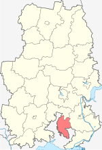
The area is located in the southern part of the republic and borders on the Malopurginsky district in the north, Sarapulsky in the east and the Republic of Tatarstan in the south and west. The area is located on the Sarapul Upland [4] . Rivers flow through its territory - Shikhostanka , Medvezhinka , Igrovka , Kryndinka and many others.
The area of the district is 821.27 km² [5] . The forest cover of the region is 23.3%, while the average for Udmurtia is 46.8% [6] .
History
On February 27, 1924, the Presidium of the Ural Regional Executive Committee of the Soviets of Workers, Peasants and Red Army Deputies approved a network of created districts in all districts of the Ural region, including the Kiyasov district of the Sarapul district. Finally, the Kiyasovsky district as part of the Sarapul district of the Ural region was approved by the Decree of the All-Russian Central Executive Committee on November 4, 1926 "On the approval of the network of regions of the Ural region." By the Decree of the Presidium of the All-Russian Central Executive Committee of January 1, 1932, Kiyasovsky District was transferred to the enlarged Sarapulsky District of the Urals Region (from February 1934 - Sverdlovskaya ) [7] .
According to the decree of the Presidium of the All-Russian Central Executive Committee of December 7, 1934, the Sarapulsky district was transferred from the Sverdlovsk Region to the Kirov Territory (from December 1936 - the Kirov Region). The decree of the All-Russian Central Executive Committee of January 23, 1935 “On the network of districts of the Kirov Territory” re-formed Kiyasovsky district [7] . By the decree of the All-Russian Central Executive Committee on October 22, 1937, the Kiyasovsky district was transferred from the Kirov region to the Udmurt Autonomous Soviet Socialist Republic [8] .
On February 1, 1963, the Kiyasovsky district was liquidated, its village councils were transferred to Izhevsk and Sarapul rural areas, but on January 12, 1965 it was restored as an independent territorial unit [9] .
As a result of the municipal reform, from January 1, 2006, it was endowed with the status of a municipal district .
Population
| Population | |||||||
|---|---|---|---|---|---|---|---|
| 1959 [10] | 1970 [11] | 1979 [12] | 1989 [13] | 2002 [14] | 2009 [15] | 2010 [16] | 2011 [17] |
| 16,585 | ↘ 14 508 | ↘ 13 555 | ↘ 12 603 | ↘ 11 550 | ↗ 11 555 | ↘ 10 305 | ↗ 10 316 |
| 2012 [18] | 2013 [19] | 2014 [20] | 2015 [21] | 2016 [22] | 2017 [2] | ||
| ↘ 10 279 | ↘ 10 097 | ↘ 9889 | ↘ 9589 | ↘ 9568 | ↘ 9441 | ||
- National composition
According to the results of the 2002 census , among the population of the region, Udmurts accounted for 38%, Russians - 54.3%, Tatars - 5% [3] . Kiyasovsky district is one of 8 rural areas of the republic, where Russians make up the majority.
Administrative Division
The Kiyasovsky district as an administrative-territorial unit includes 8 village councils [23] [24] . Village councils (rural administrations) are of the same name as rural settlements formed within their borders [25] .
The municipal district includes 8 municipalities with the status of rural settlements [26] .
| No. | Rural settlement | Administrative center | amount populated points | Population | Square, Km 2 |
|---|---|---|---|---|---|
| one | Ermolaevskoe | village of Ermolaevo | 6 | ↘ 1096 [2] | 200.19 [1] |
| 2 | Ildibaevskoe | Ildibaevo village | five | ↘ 442 [2] | 82.50 [1] |
| 3 | Karamas-Pelginskoe | village of Karamas Pelga | 3 | ↘ 636 [2] | 70,20 [1] |
| four | Kiyasovskoe | Kiyasovo village | 3 | ↗ 3309 [2] | 69.28 [1] |
| five | Lutokhinskoe | Lutoha village | four | ↘ 579 [2] | 90.60 [1] |
| 6 | Mushakovskoe | Mushak village | 2 | ↗ 369 [2] | 66.00 [1] |
| 7 | May Day | Pervomaisky village | five | ↘ 956 [2] | 100.60 [1] |
| eight | Podgornovskoe | Podgornoye village | 6 | ↘ 2054 [2] | 141.90 [1] |
Settlements
Kiyasovsky district includes 34 settlements.
| List of settlements of the district | ||||
|---|---|---|---|---|
| No. | Locality | Type of | Population | Rural settlement |
| one | Aksarino | village | ↗ 133 [27] | May Day |
| 2 | Atabaevo | village | ↗ 457 [27] | Podgornovskoe |
| 3 | Baysary | village | ↗ 83 [27] | Karamas-Pelginskoe |
| four | Upper Malaya Salya | village | ↗ 141 [27] | Ermolaevskoe |
| five | Danilovo | village | ↗ 95 [27] | Podgornovskoe |
| 6 | Dubrovsky | village | ↘ 166 [27] | Lutokhinskoe |
| 7 | Ermolaevo | village | ↘ 285 [27] | Ermolaevskoe |
| eight | Game | village | ↘ 76 [27] | Kiyasovskoe |
| 9 | Ildibaevo | village | ↘ 350 [27] | Ildibaevskoe |
| ten | Kady Salya | village | ↘ 165 [27] | Ermolaevskoe |
| eleven | Kalashur | village | ↗ 323 [27] | Lutokhinskoe |
| 12 | Karamas Pelga | village | ↘ 569 [27] | Karamas-Pelginskoe |
| 13 | Kiyasovo | village | ↘ 3200 [27] | Kiyasovskoe |
| 14 | Kosolapovo | village | ↗ 136 [27] | May Day |
| 15 | Kumyrsa | village | → 62 [27] | Ermolaevskoe |
| sixteen | Lootha | village | ↘ 141 [27] | Lutokhinskoe |
| 17 | Small Kiyasovo | village | ↘ 17 [27] | Ildibaevskoe |
| 18 | Mikhailovsk | village | ↘ 7 [27] | Ildibaevskoe |
| nineteen | Mushak | village | ↘ 243 [27] | Mushakovskoe |
| 20 | Lower Malaya Salya | village | → 170 [27] | Ermolaevskoe |
| 21 | May Day | village | → 671 [27] | May Day |
| 22 | Podgorny | village | ↗ 1641 [27] | Podgornovskoe |
| 23 | Pushin Cape | village | ↘ 5 [27] | Podgornovskoe |
| 24 | Sabanchino | village | ↗ 66 [27] | Lutokhinskoe |
| 25 | Sannikovo | village | ↘ 47 [27] | Kiyasovskoe |
| 26 | Old Salya | village | ↘ 529 [27] | Ermolaevskoe |
| 27 | Sutyagino | village | → 12 [27] | Ildibaevskoe |
| 28 | Tawzamal | village | ↘ 148 [27] | Mushakovskoe |
| 29th | Timeevo | village | ↗ 1 [27] | Podgornovskoe |
| thirty | Troeglazovo | village | ↘ 29 [27] | Podgornovskoe |
| 31 | Unur-Kiyasovo | village | ↗ 77 [27] | Karamas-Pelginskoe |
| 32 | Chuvashka | village | → 135 [27] | Ildibaevskoe |
| 33 | Shihostanka | village | ↗ 69 [27] | May Day |
| 34 | Yazhbakhtino | village | ↘ 30 [27] | May Day |
Local government
State power in the district is carried out on the basis of the Charter, the structure of local government of the municipal district is [28] [29] :
- The District Council of Deputies is a representative body of local self-government, consisting of 23 deputies, elected every 5 years.
- The head of the municipality is the highest official of the district, elected by the Council from among its members. The post of the Head of the district is occupied by Maximov Alexander Vyacheslavovich.
- The administration of the municipality is the executive-administrative body of the municipal district. The head of the district administration is appointed by the Council following the results of the competition. The position of the Head of the District Administration is occupied by Sergey Merzlyakov.
- Symbolism of the area
The official symbols of the municipal district are the coat of arms and flag, reflecting historical, cultural, national and other local traditions and features [29] .
District Budget
Execution of the district consolidated budget for 2009 [30] :
- Revenues - 226.6 million rubles, including own revenues - 17.4 million rubles (7.7% of revenues).
- Costs - 238.7 million rubles. The main expense items: housing and communal services - 12.1 million rubles, education - 124.8 million rubles, culture - 11.1 million rubles, healthcare - 15.9 million rubles, social policy - 31.3 million rubles.
Social Infrastructure
The district's education system includes 14 schools, including 10 secondary and 11 kindergartens. Institutions of further education include: 2 music schools, a home for children's creativity and a youth sports school . Medical care for the population is provided by the Kiyasovskaya Central District Hospital MBUZ (official site of the Kiyasovskaya Central District Hospital MBUZ: www.kiasovo.udmmed.ru). Also in the district there are 22 houses of culture and club institutions, 12 libraries and a museum [31] .
Economics
Kiyasovsky district is agricultural. The share of agricultural production is 80% of the total output in the area.
The main activities of the agricultural enterprises of the region are - production of milk, meat of cattle and pigs, grain growing. The agro-industrial complex of the region is represented by 59 enterprises engaged in the production of agricultural products.
The area of agricultural land is 57.4 thousand ha. As of the beginning of 2010, the number of cattle amounted to 8925 heads, including 3179 cows [32] .
People associated with the area
- Korobeinikov, Afanasy Guryanovich (1898, village Kiyasovo - 1972) - participant of the Great Patriotic War, Hero of the Soviet Union
- Shamshurin, Vasily Grigoryevich (1920, village of Krasnoyarsk - 1942) - guard junior lieutenant, IL-2 pilot of the 7th guards assault aviation regiment of the 230th assault aviation division of the 4th air army Transcaucasian Front . He died in battle on 11/18/1942.
Notes
- ↑ 1 2 3 4 5 6 7 8 9 Republic of Udmurtia. The total land area of the municipality
- ↑ 1 2 3 4 5 6 7 8 9 10 The population of the Russian Federation by municipalities as of January 1, 2017 (July 31, 2017). Date of treatment July 31, 2017. Archived July 31, 2017.
- ↑ 1 2 Kiyasovsky district (unavailable link) . Office of the Chief Federal Inspector for the Udmurt Republic. Date of treatment January 9, 2010. Archived May 18, 2008.
- ↑ Udmurt Republic: Encyclopedia / Ch. ed. V.V. Tuganaev . - Izhevsk: Udmurtia, 2000 .-- S. 14. - 800 p. - 20,000 copies. - ISBN 5-7659-0732-6 .
- ↑ Error in footnotes ? : Invalid
<ref>; no reference for GosKomStat footnotes - ↑ Developed by Lesproekt LLC in conjunction with the Federal State-Funded Educational Institution of Higher Professional Education Izhevsk State Agricultural Academy with the consulting support of the Roslesinforg branch of the FSUE Volga Forest Project. Forest Plan of the Udmurt Republic . - Izhevsk, 2010 .-- S. 33. - 260 p. (inaccessible link)
- ↑ 1 2 General information about the Kiyasovsky district (Inaccessible link - history ) . State Council of UR. Date of treatment January 4, 2010.
- ↑ About the transfer of the Votkinsk, Sarapul, Kiyasov and Karakul districts from the Kirov region to the Udmurt Autonomous Soviet Socialist Republic . Date of treatment May 18, 2013.
- ↑ Directory of the administrative-territorial division of Udmurtia / Compiled by O. M. Beznosova, S. T. Derendyaev, A. A. Korolev. - Izhevsk: Udmurtia, 1995 .-- S. 381-382. - 744 p. - 2000 copies. - ISBN 5-7659-0425-4 .
- ↑ 1959 All-Union Census of the Population . Date of treatment October 10, 2013. Archived October 10, 2013.
- ↑ 1970 All-Union Census. The current population of cities, urban-type settlements, districts, and regional centers of the USSR according to the census as of January 15, 1970, in the republics, territories, and regions . Date of treatment October 14, 2013. Archived October 14, 2013.
- ↑ All-Union Census of 1979
- ↑ All-Union Population Census of 1989 . Archived August 23, 2011.
- ↑ 2002 All-Russian Population Census. Tom. 1, table 4. The population of Russia, federal districts, constituent entities of the Russian Federation, regions, urban settlements, rural settlements - district centers and rural settlements with a population of 3 thousand or more . Archived February 3, 2012.
- ↑ The number of permanent population of the Russian Federation by cities, urban-type settlements and districts as of January 1, 2009 . Date of treatment January 2, 2014. Archived January 2, 2014.
- ↑ Results of the 2010 All-Russian Population Census. 5. The population of Russia, federal districts, constituent entities of the Russian Federation, districts, urban settlements, rural settlements - district centers and rural settlements with a population of 3,000 or more . Date of treatment November 14, 2013. Archived November 14, 2013.
- ↑ Udmurtia. Estimation of the population as of January 1 of the current year 2009-2015
- ↑ Population of the Russian Federation by municipalities. Table 35. Estimated resident population as of January 1, 2012 . Date of treatment May 31, 2014. Archived May 31, 2014.
- ↑ The population of the Russian Federation by municipalities as of January 1, 2013. - M.: Federal State Statistics Service of Rosstat, 2013. - 528 p. (Table 33. The population of urban districts, municipalities, urban and rural settlements, urban settlements, rural settlements) . Date of treatment November 16, 2013. Archived November 16, 2013.
- ↑ Table 33. The population of the Russian Federation by municipalities as of January 1, 2014 . Date of treatment August 2, 2014. Archived on August 2, 2014.
- ↑ The population of the Russian Federation by municipalities as of January 1, 2015 . Date of treatment August 6, 2015. Archived on August 6, 2015.
- ↑ Population of the Russian Federation by municipalities as of January 1, 2016
- ↑ Law "On the administrative-territorial structure of the Udmurt Republic"
- ↑ Constitution of the Udmurt Republic
- ↑ The number of administrative-territorial units and municipalities as of January 1, 2016 in the Udmurt Republic
- ↑ Law of the Udmurt Republic of December 17, 2004 N 86-РЗ “On Establishing the Boundaries of Municipalities and Giving the corresponding Status of Municipalities in the Kiyasovsky District of the Udmurt Republic”
- ↑ 1 2 3 4 5 6 7 8 9 10 11 12 13 14 15 16 17 18 19 20 21 22 23 24 25 26 27 28 29 30 31 32 33 34 Catalog of settlements of the Udmurt Republic. The number of resident population on January 1, 2012 . Date of treatment March 24, 2015. Archived March 24, 2015.
- ↑ FZ-131 “On the General Principles of the Organization of Local Self-Government in the Russian Federation” (Inaccessible link) . Date of treatment May 11, 2013. Archived March 4, 2016.
- ↑ 1 2 Charter of the Kiyasovsky District municipality (unavailable link) (as amended by the decisions of the Kiyasovsky District Council of Deputies dated May 22, 2006 No. 287, dated February 19, 2007 No. 42, dated May 29, 2007 No. 81, dated April 21, 2007 .2008 No. 152). Date of treatment June 23, 2010. Archived April 1, 2012.
- ↑ Execution of the consolidated budget of the district for 2009 (Inaccessible link - history ) . State Council of UR. Date of treatment June 1, 2010.
- ↑ Social infrastructure institutions (inaccessible link - history ) . State Council of UR. Date of treatment January 23, 2010.
- ↑ Kiyasovsky district - Ministry of Agriculture and Food of the UR (Inaccessible link - history ) .
Links
- The official website of the administration of Kiyasovsky district
- Kiyasovsky district on the website of the State Council of the UR (Inaccessible link) . Archived on May 16, 2011.