Ulu-Uzen Vostochny also Megapotamo ( Ukrainian. Ulu-Uzen Schіdny , Crimean tat. Qarqiy Ulu Özen, Sharkiy Ulu Ozen ) - a river on the southern coast of Crimea . The length of the river is 12 km, the catchment area is 33.5 km², the average annual flow at the Yalta hydropost is 0.382 m³ / s, and there are 7 tributaries by the river [2] . The name translates from the Greek ( Μεγάλος ποταμ ) and the Crimean Tatar as “big (great) river (stream)”. Privately referred to as Ulu-Uzen Vostochny, to distinguish it from the south-west of the Ulu-Uzen Alushta River .
| Ulu-Uzen East | |
|---|---|
| ukr Ulu-Uzen Schіdniy , Crimean Tat. Şarqiy Ulu Özen | |
 river in the area of the waterfall Jur-Jur river in the area of the waterfall Jur-Jur | |
| Characteristic | |
| Length | 12 km |
| Pool | 33.5 km² |
| Water flow | 0.382 m³ / s (Solnechnogorskoe) |
| Watercourse | |
| Source | |
| • Location | Demerdzhi-Yayla / |
| Mouth | Black Sea |
| • Location | Solnechnogorskoe |
| • Height | 0 m |
| • Coordinates | |
| Location | |
| A country |
|
| Region | Crimea |
| Area | Alushta City Council |

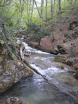
The river begins on the slopes of Demerdzhi-Jayla , then flows through the Hapkhal gorge at an altitude of 468 m above sea level, in which, near the village of Generalskoye (Ulu-Uzen, Mega-Potam), forms a series of rapids and 15-meter high Jur-Jur waterfall . The waterfall does not dry up even in the driest years. Since 1974, the Hapkhal Gorge has been declared a state hydrological reserve of republican significance , with a total area of 250 hectares.
Ulu-Uzen Vostochny flows into the Black Sea on the territory of the village of Solnechnogorskoe (Kuru-Uzen, Xero-Potam).

Thresholds of Ulu-Uzen East

Water intake

Valley

Bridge

Waterfall Jur-Jur


Notes
- ↑ This geographical object is located on the territory of the Crimean Peninsula , most of which is the object of territorial disputes between Russia , which controls the disputed territory, and Ukraine , within the borders of which are recognized by the international community, the disputed territory is located. According to the federal structure of Russia , in the disputed territory of the Crimea, the constituent entities of the Russian Federation are located - the Republic of Crimea and the city of federal importance Sevastopol . According to the administrative division of Ukraine , in the disputed territory of the Crimea are located the regions of Ukraine - the Autonomous Republic of Crimea and the city with a special status Sevastopol .
- ↑ AA Lisovsky, V.A. Novik, Z.V. Timchenko, Z.R. Mustafayeva. Surface water bodies of Crimea (reference book) / AA Lisovsky. - Simferopol : Reskomvodkhoz ARK, 2004. - p. 10, 24. - 114 p. - 500 copies - ISBN 966-7711-26-9 .
Links
- Rivers of the southern coast of Crimea (inaccessible link - history ) . web.archive.org . The appeal date is January 18, 2019.
- Toponomic Dictionary of Crimea . www.moscow-crimea.ru . The appeal date is January 18, 2019.
- The list of territories and objects of the natural reserve fund of the Autonomous Republic of Crimea of national and local significance as of January 1, 2001 (without the city of Sevastopol) (Inaccessible reference is history ) . www.ark.gov.ua.