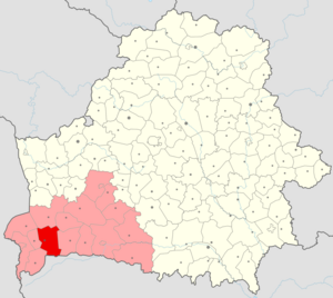
Kobrinsky district ( Belorussian. Kobrynsky rayan ) is an administrative-territorial unit within the Brest region of Belarus . The regional center is the city of Kobrin . As of January 1, 2016, the population of the district amounted to 85,436 people, of which 52,655 people live in Kobrin, the remaining 32,781 in rural areas. The area of the district is 2,039.79 km 2 .
| area | |||||
| Kobrin district | |||||
|---|---|---|---|---|---|
| Belor. Kobrynsky rayan | |||||
| |||||
| A country | |||||
| Included in | Brest region | ||||
| Adm. center | Kobrin | ||||
| Chairman of the district executive committee | Grishkevich Mikhail Mikhailovich [1] | ||||
| History and Geography | |||||
| Area | 2,039.79 [2] km² (7th place ) | ||||
| Height | |||||
| Timezone | UTC + 3 | ||||
| Population | |||||
| Population | ▼ 85 047 [3] people ( 2018 ) ( 1st place ) | ||||
| Density | 41.69 people / km² (2nd place) | ||||
| Nationalities | Belarusians - 87.86% Russians - 6.09% Ukrainians - 4.5%, others - 1.55% [4] | ||||
| official languages | Native language : Russian - 51.18%, Belarusian - 43.14% They talk at home: Russian - 79.08%, Belarusian - 15.68% [4] | ||||
| Digital identifiers | |||||
| Auto Code numbers | one | ||||
| Official site | |||||
 | |||||


Content
- 1 History
- 2 Geography and climate
- 2.1 Minerals
- 3 Ecology
- 4 Administrative device
- 5 population
- 6 Economics
- 7 Transport system
- 8 Culture and sport
- 9 Education and health
- 10 Attractions
- 11 Notes
- 12 Links
History
An administrative unit with a center in Kobrin was first formed after the death of the last princess, Kobrin Anna. The principality itself was transformed into a table estate - the Kobrin economy , which was owned by relatives (mainly wives) of the great Lithuanian princes . In administrative terms, the economy had the status of a district as part of the Podlaskie Voivodeship of the Grand Duchy of Lithuania . As a result of the reform in 1566, a new Beresteysk voivodship was formed from the Podlaskie Voivodeship, which included the Kobrin County [6] .
After the third division of the Commonwealth, Kobrin district became part of the Russian Empire . In 1796, the Slonim province was formed, which included the Kobrin district . The following year, the Slonim province was merged with Vilenskaya under the name of the Lithuanian province , but in 1801 it was restored as the Grodno province . The area of Kobrin district was 4,645.3 versts² with a population in 1894 of 159,209 people.
As part of the Grodno province, Kobrin county existed until 1921, when it moved to the Second Polish-Lithuanian Commonwealth in the Riga world . The county was reorganized and became a part of Polesie Voivodeship with a center in Brest as a county. Kobrin district had an area of 3,545 km ² with a population of 114 thousand people (according to the 1931 census).
As a result of the Red Army's invasion of the territory of the Second Polish-Lithuanian Commonwealth , which began on September 17, 1939, the territory of the Kobrin Povet became part of the BSSR . On January 15, 1940, the Kobrin district was formed as part of the Brest region of the BSSR .
During the Great Patriotic War , from June 1941 to July 1944, the area was under German occupation. In relation to the Jewish population of the region, the occupation authorities pursued a policy of genocide .
On December 25, 1967, an administrative reform was carried out, as a result of which the district gained modern borders.
By presidential decree No. 6 of January 4, 2002, the Kobrin district and the city of Kobrin were combined into a single administrative-territorial unit [6] .
Geography and climate
The area of the district is 2,039 km², which is 6.6% of the entire territory of the region. Farmland accounts for 1,114 km² [2] . The district borders with the Volyn region of Ukraine , as well as with the Berezovsky , Drogichinsky , Zhabinkovsky , Kamenetsk , Maloritsky and Pruzhansky districts of the Brest region. Several settlements of Divinsky and Povityevsky village councils are located in the border zone, for which there is a special regime of visits [7] . The length from south to north is 61 km, from west to east - 51 km.
In general, the flat territory of the region is clearly divided into northern and southern relief zones. The northern part is located in the Pre - Polesskaya landscape province , the southern - Polesskaya . In the north-east of the region is a hilly plain, which is the most elevated part of the territory. The highest point is a hill 169 meters high above sea level 2 km north of the village of Tevli , the lowest - 138 meters - the water edge of the Mukhavets river on the border with the Zhabinka district [8] .
18 large and small rivers with a total length of 298 km flow through the district, the largest - Mukhavets . The Dnieper-Bug Canal is also navigable. The main source of food for rivers and canals is precipitation . All rivers have water protection zones and coastal lanes. The largest lakes in the region are Luban with an area of 183 hectares and a Pig Pig with an area of 47 hectares. There are 315 artesian wells in the area . For bilateral regulation of the water regime, 3 reservoirs are located at the reclamation sites. The Bona Canal , named after Queen Bona , whose construction began in 1540, is the oldest known land reclamation facility in the Republic [6] .
The territory of the region belongs to the Central - moderately warm and moderately humid - climatic zone of the Republic, westerly winds prevail here. The warm period lasts 256 days, the cold - 109-110 days. The warmest in July, colder in January. The average monthly air temperature in July is in the range + 18-19 ° С, in January - 3,5-5 ° С. On average, 541 mm of precipitation falls annually in the region, their main amount falling in the warm period [8] .
Minerals
The area is rich in some minerals , in particular clay , loam , building sands , sapropel , peat , amber and phosphorites , but at the moment they are not being developed. The largest clay deposit is Podzemenskoye , whose total proven reserves are 45.5 million m 3 . Reserves of the Velikolessky deposit of agrochemical raw materials (sapropels) are estimated at 108.8 million m 3 . Partially on the territory of the region there is the largest peat deposit - Kobrinsko-Pruzhansko-Gantsevichskoe, the peat area of which is 23% [9] .
Ecology
The green zone of the Kobrin district is 4,954 hectares. Among the tree species, pine , birch , spruce and alder are the most common, less common are oaks , hornbeams , willows , ash and elms . Ginkgo bilobate also grows in the area - a rare plant that has received the status of a specially protected natural monument [8] .
The swamps of the region are lowland . Among marsh vegetation, sedge , mosses and shrubs dominate. The following plants are listed in the Red Book of the Republic of Belarus on the territory of the region: venus slipper, tuberous tufts, Sarmatian censer, Siberian killer whale, long-legged cockroach, white water lily, scepter-like scythe, ivy ordinary, egg-shaped hiding place [8] .
In the region, there is a republican landscape reserve “ Zvanets ” with an area of 1508 hectares, which is part of the largest untouched lowland swamp in Europe, as well as a biological reserve of local importance “Divin - Great Forest” with an area of 3000 hectares. Natural monuments of republican significance in the region are represented by the Suvorov Park of Culture and Leisure in Kobrin and the Suvorov Oak in Divin [8] .
Administrative device
There are 162 settlements in the district, of which one urban (the city of Kobrin, the administrative center of the district) and 161 rural settlements consisting of 11 village councils :
- Batchinsky Village Council
- Bukhovichsky village council
- Gorodets village council
- Divinsky Village Council
- Zalessky Village Council
- Kiselevets Village Council
- Novoselkovsky Village Council
- Ostromichsky Village Council
- Povityevsky Village Council
- Tevelsky Village Council
- Khidrinsky Village Council
Abolished village councils:
- Oniskovichsky
- Osovsky
A complete list of settlements in the district is presented in a separate list .
Population
According to the 2009 census , the population of the district is 88,037 people, of which 51,166 people live in Kobrin, and the remaining 36,871 in rural areas [4] .
According to preliminary data for January 2012, the population of the district decreased to 86 601 people, of which 37 207 people are employed in the economy [10] . Representatives of more than 50 nationalities and nationalities live in the region, 52 religious communities of eight religious denominations operate [6] .
During the 2009 census, about 88% of the district's residents called themselves Belarusians , about 6% - Russians and 4.5% - Ukrainians . A little more than half of the respondents named Russian as their native language , about 43% - Belarusian . According to the same data, about 79% of the district’s inhabitants speak Russian at home, and about 16% speak Belarusian [4] .
The birth rate in 2010 was 12.3 per 1000 people, the mortality rate was 14.8 [11] . In 2017, 566 marriages (6.6 per 1000 people) and 262 divorces (3.1) were concluded in the district [12] . The registered unemployment rate at the end of the same year was 1.3% of the economically active population; on average, each inhabitant has 28 m 2 of the total area of housing (in 2000 - 22.1 m 2 , in 2005 - 25.4 28 m 2 ) [11] . The nominal accrued average monthly wage for the same period amounted to 987.1 thousand Belarusian rubles [11] [13] (in January 2012 - 2,214 thousand [10] [14] ).
| Population (by years) [15] | |||||||||
|---|---|---|---|---|---|---|---|---|---|
| 1996 | 2001 | 2002 | 2003 | 2004 | 2005 | 2006 | 2007 | 2008 | 2009 |
| 92,300 | ▼ 91 694 | ▼ 91 547 | ▼ 91 134 | ▼ 90 414 | ▼ 89 919 | ▼ 89 410 | ▼ 88 831 | ▼ 88 819 | ▲ 88 938 |
| 2010 | 2011 | 2012 | 2013 | 2014 | 2015 | 2016 | 2017 | 2018 | |
| ▼ 87 886 | ▼ 87 196 | ▼ 86 639 | ▼ 86 270 | ▼ 86 092 | ▼ 85 928 | ▼ 85 436 | ▼ 85 322 | ▼ 85 047 | |
| 2009 National Census [16] [17] | ||||||||||||
|---|---|---|---|---|---|---|---|---|---|---|---|---|
| total (2009) | Belarusians | Russians | Ukrainians | Poles | Armenians | gypsies | ||||||
| 88 037 | 77 345 | 87.86% | 5364 | 6.09% | 3962 | 4,5% | 525 | 0.6% | 91 | 0.1% | 91 | 0.1% |
| Tatars | Greeks | Germans | Azerbaijanis | Moldavians | Lithuanians | |||||||
| 73 | 0.08% | 59 | 0.07% | fifty | 0.06% | 35 | 0.04% | 32 | 0.04% | 17 | 0.02% | |
| Birth and death rates [18] [19] : |
| Marriage and divorce rates [20] [21] |
Economics
| Gross Grain Harvest and legumes [22] [23] , thousand tons: |
| Milk production [24] [25] , thousand tons: |
Revenue from sales of products, goods, works, services in 2017 amounted to 894.9 million rubles (about $ 447 million), including 145.4 million rubles from agriculture , forestry and fisheries, 532 million from industry , 49 million for construction, 135.9 million for trade and repair, 32.6 million for other types of economic activity [26] .
As of April 2018, 18 industrial enterprises are functioning in the region [27] . Among the industries, the most developed food (OJSC Kobrinsky Butter and Cheese-Making Plant, OJSC Kobrinsky Meat Processing Plant, OJSC Kobrinsky Canning Factory, Kobrinsky Bakery (a branch of OJSC Beresteysky Pekar), RUSPP “Kobrinsk Poultry Factory”), light (branch of OJSC “Mogotex”, spinning and weaving factory “Ruchayka”), chemical ( JLLC “PP Polesie”, Belarusian-German joint venture “Color”), metalworking and machine-building ( RUPE “Kobrin Tool Plant“ Sitomo ””, OJSC “ SALEO-Kobrin ”, “Kobrinagromash”). About 50 enterprises with foreign capital work in the region, many goods of industrial enterprises are exported [28] [29] .
The agro-industrial complex of the district includes 12 agricultural production cooperatives, 9 open joint-stock companies, KSUP "Breeding factory" Friendship "", a branch of "Orekhovskoye" state-owned enterprise "Bresttorchermet", IOOO "BissoloGabrieleFarm", state variety testing institution, 36 farms [28] . In the village of Kozishche there is an ostrich farm "PM and Company" [30] .
In 2017, the agricultural organizations of the district collected 94.5 thousand tons of grain and leguminous crops with a yield of 32.5 kg / ha, 118 tons of flax fiber with a yield of 13 kg / ha, 77.6 thousand tons of sugar beets with a yield of 385 kg / ha [31] . 29.8 thousand hectares of arable land were sown for grain crops in 2017, 0.1 thousand hectares for flax, 2.2 thousand hectares for sugar beets, and 31.8 thousand hectares for fodder crops [32 ] . As of January 1, 2018, the agricultural organizations of the district contained 58.7 thousand heads of cattle, including 20.8 thousand cows, 29.9 thousand pigs, 489.8 thousand heads of poultry [33] . In 2017, the agricultural organizations of the region sold 12.7 thousand tons of cattle and poultry meat and produced 99.5 thousand tons of milk [34] .
In the field of trade, there are 561 stores, 341 of them operate according to the self-service method [28] .
Transportation System
The Druzhba oil pipeline , 3 gas pipelines , two lines of the Belarusian Railway - from west to east ( Zhabinka - Gomel branch, Kobrin and Gorodets stations) and from west to northeast (Brest- Moscow branch, Tevli station ) pass through the district .
The roads of the Minsk , Pinsk , Kovel , Grodno and Brest directions run through the district. Navigation is carried out along the Dnieper-Bug Canal [28] .
| Roads passing through the Kobrin district | Designations |
|---|---|
| Brest (Kozlovichi) - Kobrin - Baranovichi - Minsk - Orsha - Russian border (Radish) | M1 E 30 |
| Kobrin - Pinsk - Gomel - Russian border (Selishche) | M10 |
| Kobrin - the border of Ukraine (Mokrany) | M12 E 85 |
| Kobrin - Ivatsevichi - Columns | P2 E 85 |
| Kobrin - Kamyanets - High | P102 |
| Kobrin - Zhabinka | P104 |
| Kobrin - the border of Ukraine ( Divin ) | P127 |
Culture and sport
The structure of the culture department of the Kobrin district executive committee contains 92 cultural objects. Of these, 37 are club-type institutions, 5 art schools with eight branches, the Palace of Culture in Kobrin, the Kobrin Military History Museum named after A. V. Suvorov , Park named after Suvorov , Kobrin district cinema and video network and 47 libraries [28] .
The area has more than 390 sports facilities. Specialized children and youth school of the Olympic reserve, children and youth school in winter sports in Kobrin, a sports complex in the village of Khidry , Yunost stadium, 1 arena, 25 shooting ranges, 59 sports halls, 9 swimming pools, 225 sports grounds , 26 football fields, Atlant regional fitness center, 17 clubs for sports interests, as well as a tennis court in the village of Lelikovo . A rowing base with a rowing canal is being completed in the area; an ice arena, a water park and a ski-roller track are functioning in Kobrin [28] .
Education and Health
The educational system of the Kobrin district has 80 institutions. Educational institutions providing secondary education include the vocational-technical college of builders and the vocational lyceum of the service sector in Kobrin [28] . In 2017, there were 37 pre-school educational institutions in the district that served 3,792 children. In 38 schools of general secondary education in the academic year 2017/2018, 10 489 children were enrolled, 1384 teachers provided the educational process [35] [36] .
Среди медицинских учреждений в районе действуют центральная районная больница, 3 участковые больницы, 1 больница сестринского ухода, 10 амбулаторий, 25 фельдшерско-акушерских пунктов, станция скорой медицинской помощи, 8 аптек, медико-социальное учреждение «Кобринский психоневрологический интернат» [28] .
Attractions
В Государственный список историко-культурных ценностей Республики Беларусь внесены 45 историко-культурных недвижимых ценностей в пределах района. Среди них: 15 памятников археологии , 26 памятников архитектуры , 3 памятника истории , парк имени Суворова [8] .
Среди памятников, находящихся на местном учёте, насчитывается [8] :
- 12 памятников археологии;
- 9 старинных захоронений и валунов ;
- 35 памятников культового строительства ;
- 9 усадеб ;
- 3 памятника истории и 1 мемориальная доска, посвящённые войне 1812 года ;
- 9 памятников истории времён Первой мировой и советско-польской войн (6 воинских кладбищ Первой мировой войны);
- 5 памятников истории времен Кобринщины в состав II Речи Посполитой;
- 93 памятника Великой Отечественной войны ;
- 14 памятников землякам и государственным деятелям. Возле деревни Ляхчицы в урочище Княжая Гора находится могила, в которой по преданию похоронена княгиня Ольга .
Notes
- ↑ Кобринский районный исполнительный комитет - Председатель районного исполкома
- ↑ 1 2 «Государственный земельный кадастр Республики Беларусь» (по состоянию на 1 января 2011 г.).
- ↑ Численность населения на 1 января 2018 г. и среднегодовая численность населения за 2016!7 год по Республике Беларусь в разрезе областей, районов, городов и посёлков городского типа. // Национальный статистический комитет Республики Беларусь. — Мн., 2018.
- ↑ 1 2 3 4 Результаты переписи 2009 года // Национальный статистический комитет Республики Беларусь. (Проверено 6 июня 2011)
- ↑ GeoNames - 2005.
- ↑ 1 2 3 4 Кобринский район // Регионы Брестской области. (Проверено 6 июня 2011)
- ↑ Перечень населенных пунктов, расположенных в пограничной зоне
- ↑ 1 2 3 4 5 6 7 Кобринский район // Карты Брестской области. (Проверено 6 июня 2011)
- ↑ Кобринский район // Карты Брестской области. (Проверено 7 марта 2012)
- ↑ 1 2 Кобринский район // Статистические данные о социально-экономическом развитии городов областного подчинения и районов в январе-феврале 2012 г. (Проверено 3 апреля 2012)
- ↑ 1 2 3 Кобринский район // Регионы Республики Беларусь в цифрах, 2011. Брестская область. (Проверено 3 апреля 2012)
- ↑ Статистический ежегодник Брестской области. — Мн. : Национальный статистический комитет Республики Беларусь, 2018. — С. 65–69.
- ↑ Около 330 долларов США в пересчёте на курс конца 2010 года. См. Официальный курс белорусского рубля по отношению к иностранным валютам, устанавливаемый Национальным банком Республики Беларусь ежедневно, на 31.12.2010 . (Проверено 3 апреля 2012)
- ↑ Около 265 долларов США в пересчёте на курс конца января 2012 года. См. Официальный курс белорусского рубля по отношению к иностранным валютам, устанавливаемый Национальным банком Республики Беларусь ежедневно, на 31.12.2010 . (Проверено 3 апреля 2012)
- ↑ Численность населения по городам и районам Брестской области Архивная копия от 20 апреля 2018 на Wayback Machine , Главное статистическое управление Брестской области
- ↑ Перепись населения 2009. Национальный состав Республики Беларусь. Том 3 . — Мн. , 2011 — С. 106—109.
- ↑ Национальный состав населения Брестской области
- ↑ Статистический ежегодник Брестской области. — Мн. : Национальный статистический комитет Республики Беларусь, 2013. — С. 55–56.
- ↑ Статистический ежегодник Брестской области. — Мн. : Национальный статистический комитет Республики Беларусь, 2018. — С. 46–49.
- ↑ Статистический ежегодник Брестской области. — Мн. : Национальный статистический комитет Республики Беларусь, 2013. — С. 71–73.
- ↑ Статистический ежегодник Брестской области. — Мн. : Национальный статистический комитет Республики Беларусь, 2018. — С. 66–69.
- ↑ Статистический ежегодник Брестской области. — Мн. : Национальный статистический комитет Республики Беларусь, 2013. — С. 253.
- ↑ Статистический ежегодник Брестской области. — Мн. : Национальный статистический комитет Республики Беларусь, 2018. — С. 254.
- ↑ Статистический ежегодник Брестской области. — Мн. : Национальный статистический комитет Республики Беларусь, 2013. — С. 272.
- ↑ Статистический ежегодник Брестской области. — Мн. : Национальный статистический комитет Республики Беларусь, 2018. — С. 272.
- ↑ Регионы Республики Беларусь. — Т. 1. — Мн. : Национальный статистический комитет Республики Беларусь, 2018. — С. 634.
- ↑ Промышленность // сайт Кобринского райисполкома.
- ↑ 1 2 3 4 5 6 7 8 Описание и карта района // Кобринский районный исполнительный комитет. (Проверено 6 июня 2011)
- ↑ Кобринский район // Справочник предприятий Брестской области. (Проверено 6 июня 2011)
- ↑ Страус просится в тарелку // Проект «100 дорог». — TUT.BY , 07 июня 2009. (Проверено 6 июня 2011)
- ↑ Статистический ежегодник Брестской области. — Мн. : Национальный статистический комитет Республики Беларусь, 2018. — С. 254—262.
- ↑ Сельское хозяйство Республики Беларусь. — Мн. : Национальный статистический комитет Республики Беларусь, 2018. — С. 71—78.
- ↑ Сельское хозяйство Республики Беларусь. — Мн. : Национальный статистический комитет Республики Беларусь, 2018. — С. 137—145.
- ↑ Сельское хозяйство Республики Беларусь. — Мн. : Национальный статистический комитет Республики Беларусь, 2018. — С. 157—161.
- ↑ Статистический ежегодник Брестской области. — Мн. : Национальный статистический комитет Республики Беларусь, 2018. — С. 132—133.
- ↑ Статистический ежегодник Брестской области. — Мн. : Национальный статистический комитет Республики Беларусь, 2018. — С. 138—140.
Links
- Кобринский районный исполнительный комитет
- Достопримечательности района на сайте «Глобус Беларуси» . (Проверено 19 мая 2016)
- Достопримечательности района на сайте Radzima.org . (Проверено 19 мая 2016)