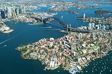
Port Jackson [1] [2] ( eng. Port Jackson ) is a three-arm bay in the southeastern part of the coast of Australia , which includes an extended Sydney harbor (Eng: Sydney Harbor ) 20 km long with a width of 1-3 km and a depth of 60 m (this is the southern and largest sleeve of the bay, curved and therefore protected from ocean waves), as well as the less extended Middle Harbor Bay (Eng: Middle Harbor - Middle Harbor) and North Harbor Harbor (Eng: North Harbor - North Harbor ), having a common strait 1.4 km wide with the Pacific Ocean.
| Port jackson | |
|---|---|
| English Port jackson | |
 Port Jackson Bay | |
| Specifications | |
| Bay Type | the bay |
| Square | 55 km² |
| Coastline | 317 km |
| Deepest | 60 m |
| Flowing rivers | Middle Harbor Creek , Lane Cove , Parramatta , Duck |
| Location | |
| Upstream water area | Tasman Sea |
| A country |
|
| Region | N.S.W. |


Port Jackson was discovered (but not explored in detail) by J. Cook during his voyage along the east coast of Australia in 1770 . The bay served as the base for the first European colony in Australia when the First Fleet moved here, originally coming to Botany Bay, located south of it.
Port Jackson is a natural harbor for Sydney and is the most convenient place for the construction of ports. Since the founding of the first European settlements in Australia, the bay continues to play a key role in the history of Sydney and the whole country.
Port Jackson is famous for architectural monuments such as the Sydney Opera House and Harbor Bridge .
In Port Jackson, the Sydney - Hobart ( Tasmania ) yacht route begins and hosts the annual New Year show with fireworks .
History

The lands around Port Jackson (and Sydney Bay, as part of it) before their European colonization were actively inhabited by local tribes of Australian aborigines , such as gadigals, eora and others. The origin of many of them is not known for certain. The gadigals, for example, had a habitat on the southern shore of this bay.
In 1770, the famous British explorer and traveler James Cook saw the bay. It is believed that he was the first European to fix the position of this bay on the map. Moving from the New Zealand surveyed by him to the southeastern part of Australia (the new land he discovered, which he named New South Wales ), James Cook, after a thorough examination of Botany Bay, went north along the coast of the new open land. After 12 km, he discovered another large bay. James Cook marked it on the map as “Port Jackson”, in honor of Sir George Jackson - sponsor of the British Admiralty [3] , but did not examine this bay in detail, unlike Botany Bay.
In 1788, on January 26, the First Fleet moved here from Botany Bay . And on the shore around a small circular bay called Sydney Cove in the central part of Sydney Harbor - the southern long curved arm (that is, protected from direct waves from the ocean) of Port Jackson Bay - the first was founded Permanent settlement of Sydney on the continent of Australia.
In 1932, in the historic center of Sydney, the famous Harbor Bridge was thrown across Sydney Bay (the southern arm of Port Jackson Bay).
In 1942, a large-scale campaign for the construction of structures against the penetration of Japanese submarines into the bay began in Port Jackson Bay [4] .
In 1975, the still untouched territory of the bay was combined into the Sydney Harbor National Park .
At the entrance to Port Jackson on the south side of the strait separating Port Jackson from the Tasman Sea , on the South Head Peninsula ( South Head ), Macquarie Lighthouse is the oldest in Australia.
Notes
- ↑ Australian Dictionary of Geographical Names. - M .: TsNIIGAiK , 1986
- ↑ Atlas of the world . - 3rd ed. - M.: Federal Service of Geodesy and Cartography of Russia, 2002. - 563 pp. ISBN 5-85120-055-3
- ↑ McDermott, Peter Joseph (1878-11-06). "Pacific Exploration." The Brisbane Courier (Brisbane Newspaper Company Ltd): pp. 5. Retrieved 2008-11-05]
- ↑ en: File: WatsonsBay0201.JPG (English)