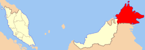
Sabah ( Malay. Sabah, negeiri di bawah bayu , jawi: سابه; code: SBH ) - the governorship of Malaysia . Located in East Malaysia and is the second largest state in Malaysia, it is also called Negeri di bawah bayu , which means "Country below the winds." Previously, being a British colony, it was called British North Borneo [1] [2] [3] [4] , later it received the status of the state of the Malayan Federation [5] . In the west, it borders with another Malaysian state on the island of Kalimantan - Sarawak . In the south it has a border with Indonesia . The administrative center is the city of Kota Kinabalu . The Governor is Juhar Mahiruddin.
| state of malaysia | |||||
| Sabah | |||||
|---|---|---|---|---|---|
| Malaysian Sabah, negeiri di bawah bayu javi: سابه | |||||
| |||||
| Sabah Tanah Airku | |||||
| A country | Malaysia | ||||
| Includes | 5 districts | ||||
| Adm. Centre | Kota Kinabalu | ||||
| Governor | Ahmadshah Abdullah | ||||
| chief minister | Hj. Musa Bin Hj. Oman | ||||
| History and Geography | |||||
| Square | 73 619 km² (2nd place ) | ||||
Height
|
| ||||
| Timezone | UTC + 8: 00 | ||||
| Population | |||||
| Population | 3 206 742 people ( 2010 ) ( 3rd place ) | ||||
| Density | 43.56 people / km² (14th place) | ||||
| Digital identifiers | |||||
| Abbreviation | Sbh | ||||
| ISO 3166-2 Code | MY-12 | ||||
| Telephone code | |||||
| Postal codes | |||||
| Official site | |||||
 | |||||


Content
Geography
The northwestern shores of Sabah are washed by the vast South China Sea , the northeastern and southeastern shores are washed by small inter-island seas - Sulu and Sulawesi . The coastline of Sabah is indented and forms a series of closed shallow, comfortable bays for swimming. Among them are Brunei bays in the west, Murud in the north, Labuk and Darvel in the east. In some places, the coastline takes on a skerry character. Off the coast of the Sulu and Sulawesi seas there are many shallows, small islets and coral reefs that make shipping difficult. The most significant islands are Sebatik, which Sabah bisects with Indonesia, as well as Bangui, Dzhambongan, Malawali, Timbun-Mata, Bum-Bum.
Almost the entire territory of Sabah, with the exception of a narrow coastal edge, occupies a low plateau, passing in the west into the Crocker mountain range. In the northern part of this ridge is the highest peak in Malaysia and throughout Southeast Asia - Mount Kinabalu (4095 m).
The longest and most full-flowing Sabah River is Kinabatangan (560 km). In its upper and middle reaches, it flows through a narrow valley, cutting the central part of the plateau. Kinabatangan, as well as Segama , Labuk and Sugut flow from west to east and flow into the Sulu Sea. Only one more or less significant river flows into the South China Sea - the Padas . In the delta region, at the confluence of the Gulf of Brunei, the right sleeve of Klias separates from it, forming a low-lying swampy island.
Sabah's climate is equatorial, constantly hot and humid. In the mountains, the climate becomes more moderate, and at high altitude - even cooler. Precipitation falls annually from 3,750 mm in the plains to 5,000 mm in the mountains.
History
Sabah was occupied by the British in 1881 and became a protectorate . In 1946, the British Crown Colony British North Borneo was formed, and in 1963 Sabah became part of the Malay Federation .
Administrative Division
The state is divided into 5 districts:
| No. | County | Administrative center | Square, km² | Population, people (2006) [6] |
|---|---|---|---|---|
| one | West Bank | Kota Kinabalu | 7588 | 954,000 |
| 2 | Inner area | Beaufort | 18 298 | 421,000 |
| 3 | Somewhere | Somewhere | 4623 | 190,000 |
| four | Sandakan | Sandakan | 28 205 | 676,000 |
| five | Tawau | Tawau | 14 905 | 757,000 |
Population and Ethnic Composition
Many Sabah residents are partly of Portuguese origin. Common names are Fernando, Gomez, Rodriguez. Sabah festivals sometimes resemble Brazilian ones.
The population of Sabah is about two and a half million, 32 ethnic groups are officially recognized. The largest non-native ethnic group are Chinese , accounting for 20% of the population. Of the local ethnic groups, the largest is (about 25% of the population); then go bajo (15%) and (3%).
About 700 thousand people on Sabah are Filipinos who entered here due to the lack of strict control over immigration and border protection. Since the local government does not recognize the presence of illegal immigrants in Sabah, Filipinos have already taken root, occupying jobs in construction and participating in commercial activities.
Malay is a common language for all ethnic groups; Sabah adopted the Sabah dialect, which differs in intonations and is similar in pronunciation to the Indonesian language . Widespread English , Chinese ( North Chinese and Hakka ). Kadazan-dusun, bajo, murut and small nations speak their own languages.
Policy
Dispute with the Philippines
The Philippines lay claim to the entire territory of Sabah, promised by the Sultan of Borneo to the Sultanate of Sulu in 1703 for military support. [7]
Economics
Tourism
Attractions and excursions in Sabah:
- Climbing Mount Kinabalu (4095 meters).
- Cruise through ( mangroves ) in search of nosed proboscis monkeys and fireflies.
- Rafting on the rivers of Kiul (1-2 cat. Complexity) and Padas (3-4 cat. Complexity).
- Cultural Village Monsopyad (bounty hunter).
- Fishing.
- VIP cruises on the islands of Kalimantan.
In addition, Sabah is a place for excellent diving. The most popular places are north of Kota Kinabalu and near Sempornaya ( Sipadan , Mabul , Kapalay , Sibuan and others).
Culture
See also
- Colonial expansion of the Austrian Empire
- UK Colonies
- The dispute over the status of North Borneo
Notes
- ↑ United Nations List of Non-Governmental Organizations, Non-Self-Governing Territories, North Borneo and Sarawak
- ↑ Members of the United Nations
- ↑ United Nations Treaty No. 8029 between the Philippines , the Federation of Malaya and Indonesia (June 31, 1963)
- ↑ United Nations Treaty No. 8809, Agreement for the Implementation of the Manila Agreement
- ↑ No.10760: Agreement on Malaysia (Pdf) (inaccessible link) . United Nations Treaties Collection . United Nations (July 1963). Date of treatment July 29, 2010. Archived May 14, 2011.
- ↑ "Monthly Statistical Bulletin, January 2007: Sabah", Department of Statistics Malaysia, Sabah .
- ↑ Treaties and international agreements registered or filed and recorded with the Secretariat of the United Nations No. 8809, Agreement relating to the implementation of the Manila Accord