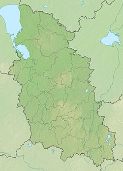
The Great is a river in the Pskov region of Russia . It refers to the basin of the River Narva (through the Pskov-Peipsi Lake ) and in general to the Baltic Sea basin .
| Great | |
|---|---|
 The Great River on the territory of Pskov The Great River on the territory of Pskov | |
| Characteristic | |
| Length | 430 km |
| Pool | 25,200 km² |
| Water flow | 134 m³ / s |
| Watercourse | |
| Source | |
| • Location | Bezhanitskaya hill |
| • Height | > 250 m |
| • Coordinates | |
| Mouth | Chudsko-Pskov Lake |
| • Height | 30.1 m |
| • Coordinates | |
| Location | |
| Water system | Lake Peipsi → Narva → Baltic Sea |
| A country |
|
| Region | Pskov region |
| HWR Code | |
Content
Basic Information
The length of the river is 430 km, the catchment area is 25,200 km², the average annual discharge at the mouth is 134 m³ / s. The source of the river is located on the Bezhanitsky Upland , in the Novosokolnichesky district , about one and a half kilometers southeast of the Yelno Lake. The river flows into the Pskov-Peipsi Lake .
In spring floods up to one and a half meters. Ice weather from November to April. Navigable in the lower reaches. On the river are the city Opochka , Island , Pskov . On the banks of the river there are many objects of cultural and historical significance. In the upper reaches of the Great is popular with fishermen, water tourists and outdoor enthusiasts.
The main tributaries are the Idritsa , Blue , Utroya , Kukhva , Vyada , Kudeb , Issa (left); Alolla , Kudka , Sorot , Cherekha , Pskov (right).
On the right bank of the river is the Snetogorsko-Murovytsky natural monument .
The height of the mouth - 30.1 m above sea level.
Characteristics along the river
The source of the Great is located on the Bezhanitsky Upland , 4 km north of Lake Bolshoi Vyaz and 1 km east of Lake Yelno in the Vyazovsky volost of the Novosokolnichesky district [2] [3] . In the upper reaches of the chain of lakes - Big Elm , Chodsho , Big Postryo , Khvino , Chenoye . After them, over a distance of 15 kilometers, a river 7–10 meters wide flows rapidly into the wooded banks, winding heavily. There are two dams on this site. Downstream the river flows a large lake Veryato (Kopylkovskoe reservoir). On exiting the lake, the width of the river is 15–20 meters; here, in the village of Kopylok, there is a partially dismantled and now inactive Kopylkovskaya hydroelectric station . Further, the river flows westward alternating ridges with small rocky shallows. The shores are very picturesque, covered with pine forest. On the site to the mouth of the right tributary Aloli Velikaya passes several more lakes - Bystroe , Yasskoe , Zverino and Ezerishche . Between Bystry and Yassky near the village of Podduby is the destroyed dam of the Podduba Hydroelectric Power Plant .
On the stretch between the mouths of Aloli and Idritsa, the river overcomes a rapids stretch, which, however, is completely hidden under water during the flood. Behind the mouth of Idritsa (5 kilometers up the tributary Idritsa is located) the Great turns sharply to the north. In the area, not far from the village of Maxyutino, is the current Maksyutinskaya hydroelectric power station . The width of the river increases to 30-40 meters, the forests along the banks become smaller, the population of the banks is larger, and the shallows are less frequent. There are several more dams on the site up to Opochka on the river, including the operating Shilskaya hydroelectric power station near the village of Shilskoye .
Below Opochka, at the confluence of the right , the woods along the banks almost disappear, the flow rate decreases . In the place where Sorot flows into the Great, it flows 5 kilometers from the village of Pushkinskiye Gory and the Pushkin Reserve . Starting from the mouth of the Blue, the width of the Great rises to 60-70 meters. To the island city, the river overcomes one more rapids and forms here numerous islands with channels between them.
Below Velikaya Island for five kilometers takes at once three large left tributaries - Morning , Kuhvu and Vyadu . The width of the river increases to 100 meters, the speed of the flow is greatly weakened. The banks are treeless, populated.
Directly in front of Pskov on Velikaya there is another short and extremely shallow rapids area - Vybytsky rapids. After the river already receives two right tributaries, the Cheryokh and the Pskov , within the city, the Great is over 100 meters wide.
Then the Great River flows into the Pskov Lake 15 kilometers below Pskov, forming a small delta , the main channels of which are Gladyshnaya, Medium, Vorona [4] [5] .
Tributaries
The table below shows all the left and right tributaries of the Great River (except streams and nameless rivers), from the mouth to the source, as well as their major tributaries over 30 km long.
| Distance niya from mouth (km) | Left tributary / Right tributary | Tributary tributaries | Length (km) | Square water gathering (km²) |
|---|---|---|---|---|
| five | Kamenka | ten | ||
| 17 | Pskov | 102 | 1000 | |
| ↑ | Pskovitsa (left) | 52 | 198 | |
| ↑ | Toroshinka (right) | thirty | 196 | |
| nineteen | Mirozhka (Mirozha) | 6 | ||
| 23 | Gap | 2.5 | ||
| 24 | Cheroha | 145 | 3230 | |
| ↑ | Keb (right) | 93 | 872 | |
| ↑ Kebtsa (Koptsa) (left) | 36 | 155 | ||
| ↑ | Petenka (right) | 46 | 251 | |
| ↑ | Larch (right) | 46 | 370 | |
| ↑ | Lzna (Alzna) (left) | 42 | 214 | |
| ↑ | Dubna (Rudenka) (right) | 40 | 214 | |
| ↑ | Dubenka (Dubna) (right) | 34 | 108 | |
| 26 | Many | 58 | 665 | |
| ↑ | Dubina (right) | 41 | 176 | |
| 43 | Sliver | thirty | 233 | |
| 56 | Smolinka | 12 | ||
| 58 | Kudeb | 82 | 760 | |
| ↑ | Lidva (left) | 31 | 144 | |
| 82 | Veda (Vyada) | 83 | 1160 | |
| ↑ | Kira (Kir) (right) | 60 | 295 [6] | |
| ↑ | Bewitching | 55 | 184 | |
| ↑ | Liepna (left) | 50 | 248 [7] | |
| 85 | Kuhva | 106 | 828 | |
| ↑ | Rika (left) | 156 | 136 [7] | |
| 87 | Morning (ritupe) | 176 | 3000 | |
| ↑ | Lzha (Ludza) (right) | 156 | 1570 | |
| ↑ | Lada (right) | 40 | 262 | |
| 92 | Sliver | 43 | 326 | |
| 107 | Foamy | 23 | 114 | |
| 114 | Stalk | 12 | ||
| 118 | Moshna (Ershovka) | 12 | ||
| 119 | Svetik (Linenka) | eleven | ||
| 129 | Blue (Zilupe) | 195 | 2040 | |
| ↑ | Istra (left) | 39 | 269 | |
| ↑ | Versha (right) | thirty | 252 | |
| 132 | Ilovka | sixteen | ||
| 143 | Vrevka | 20 | ||
| 150 | Sing | 18 | ||
| 161 | Litter | 80 | 3910 | |
| ↑ | Llsta (Lonnitsa) (left) | 80 | 1310 | |
| ↑ | Uda (right) | 63 | 871 | |
| ↑ Tree (right) | 33 | 134 | ||
| ↑ | Ashevka (right) | 33 | 335 | |
| ↑ | Sevka (right) | 33 | 137 | |
| 178 | Issa | 174 | 1580 | |
| ↑ | Vet (right) | 57 | 426 | |
| 181 | Six | 64 | 450 | |
| 199 | Kudka | 55 | 490 | |
| ↑ | Crap (Crest) (right) | 35 | 214 | |
| 255 | Chernitsa | sixteen | 311 | |
| 298 | Idritsa | 17 | 319 | |
| 306 | Nevedryanka | 55 | 564 | |
| 323 | Alolla | 105 | 860 | |
| Krupyanka (Krupeya) [8] | 28 | 238 | ||
| 385 | Yaznitsa | 2 |
Gallery
View of Velikaya from the village of Piskovichi, Pskov District
View of the Great and Olginsky Bridge from the Vlasyevskaya Tower of the Pskov Kremlin
View from the bridge of the 50th anniversary of October .
At the Pokrovskaya Tower
View of the Great and the Bridge of the name of the 50th anniversary of the October Revolution in Pskov
View of the island on Velikaya near Promezhits in Pskov
View of the Great from Promezhits in Pskov
View of Velikaya in the village of Selikhnovo in Pushkinogorye
View of the suspension bridge over the Great in Opochka
The Great River flows into Lake Pskov. View from the plane from the city of Pskov .
Notes
- ↑ Surface water resources of the USSR: Hydrological knowledge. T. 2. Karelia and the North-West / ed. E. N. Tarakanova. - L .: Gidrometeoizdat, 1965. - 700 p.
- ↑ Map sheet O-35-132-A - FSUE “GOSGISTSENTR” Scale: 1 cm 500 m
- ↑ Map sheet O-35-132-Ab - FSUE “GOSGISTSENTR” Scale 1 cm 250 m
- ↑ The mouth of the Great River. Fairways. Map.
- ↑ Map sheet O-35-81-A - FSUE “GOSGISTSENTR” Scale 1 cm 500 m
- ↑ including 277 in Latvia
- ↑ 1 2 in Latvia
- ↑ flows into the Great Lake of Ezerishche flowing
Links
- The Great (a river in the Pskov Region) // The Great Soviet Encyclopedia : [in 30 t.] / Ch. ed. A. M. Prokhorov . - 3rd ed. - M .: Soviet Encyclopedia, 1969-1978.
- Voronov Yu. B. “100 selected routes for kayak trips”. M., "World", 1993
- Photo album about the river Great
- State Water Registry . Great . textual.ru . Ministry of Environment of Russia (March 29, 2009). The appeal date was December 20, 2018. Archived March 29, 2009.