Yangkabad [1] ( Uzbek. Yangiobod, Yangiobod ) is a city (since 1953 ) in the Tashkent region of Uzbekistan . It is governed by the Angren City Council of Deputies [2] .
| City | |
| Yangiabad | |
|---|---|
| Uzbek Yangiobod | |
| A country | |
| Region | Tashkent |
| History and Geography | |
| City with | 1953 |
| Center height | about 1300 m |
| Timezone | UTC + 5 |
| Population | |
| Population | 9000 people ( 2004 ) |
| Official language | Uzbek |
As of 2004, the population was estimated at 9,000 inhabitants [2] .
Content
Location
Yangiabad is located on the southeastern slope of the Chatkal ridge at the confluence of the Dukentsay and Kattasay rivers [3] . The territory of the city is irrigated by the waters of Kattasay [4] . The height of the center of the village is about 1300 m [3] .
Yangiabad is located north of the city of Angren , whose city council is governed. Angren Train Station is 22 km away. Between the two cities there is a public transport connection (buses and minibuses) [2] .
City History
The city was originally built in the late 1940s as a town of miners mining uranium ore in uranium mines built in its vicinity. The last uranium mines were closed in the 1980s due to depletion of existing deposits. In Soviet times, when uranium mines were still operating, the city was a regime and was supported by Moscow. Now Yangiabad is a deserted city, whose population is about 10-15% of the Soviet period . In the last election of 2009, a little more than 400 voters were in the lists of the election commission, mainly of retirement age
The bulk of the city’s inhabitants during the Soviet era were residents of the European part of the USSR , mostly Russians, as well as Ukrainians and representatives of other nationalities, both civilian and prisoners, whose labor was used in uranium mines [5] . There were a small number of representatives of the indigenous nationalities of the region - Uzbeks, Kazakhs and Tajiks in the years when Yangiabad was a regime city. Currently, the bulk of the city’s population is Uzbeks and Tajiks who settled in the city after the collapse of the USSR. Often they purchase housing for recreation .
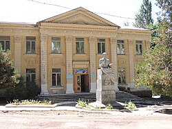
Yangiabad itself was built mainly by the forces of German immigrants from the Volga and other regions of the USSR, and not prisoners of war, as is often believed (prisoners of war returned to Germany, even to the East, would not be allowed into uranium mines). Perhaps, due to the influence of German culture, the city has a peculiar architecture reminiscent of the architecture of a German town of the 19th – 20th centuries, unexpected for the eyes of a person who first got into this Central Asian town. There are no buildings above 3 floors in the city. This is probably also associated with high seismic activity in this region. The houses were designed for 9-point earthquakes. [6]
According to the 1989 census, 11,709 people lived in Yangiabad [7] .
Infrastructure
In Yangiabad there are industrial and construction enterprises, a bus station, a post office, a network of trade, service and cultural institutions [2] .
Social Security
In Yangiabad there is a comprehensive school, a house of culture, a library, a clinic, a first-aid post, and a pharmacy [2] .
City Attractions
Near the city, at a distance of several kilometers above it, up the Kattasay river valley is the Yangiabad camp site, which was organized in the early 1970s on the basis of a closed uranium mine. Near the campsite there are several sites for winter skiing.
Up along the valley of another river - Dukentsaya , about 10 km from the city, at an absolute height of 2000 m, there is a scientific laboratory of the Tashkent Central Asian Regional Scientific Research Hydro-meteorological Institute - snow avalanche station. The station was established in 1958 to protect uranium mines operating in the vicinity of the city from snow avalanches and is the first snow avalanche station in the Republic of Uzbekistan. [eight]
Notes
- ↑ 1) Ageenko F.L. Yangiabad // Dictionary of proper names of the Russian language. Stress Pronunciation. Inflection . - M .: World and Education; Onyx, 2010 .-- 880 p. - ISBN 5-94666-588-X , 978-5-94666-588-9.
- ↑ 1 2 3 4 5 Yangiobod - National Encyclopedia of Uzbekistan . - Tashkent, 2000-2005. ( Uzbek )
- ↑ 1 2 Map sheet K-42-105 Angren . Scale: 1: 100,000. State of the terrain for 1983. 1988 edition
- ↑ Kattasoy - National Encyclopedia of Uzbekistan . - Tashkent, 2000-2005. ( Uzbek )
- ↑ [1] (link unavailable) : By this time, geologists have discovered several more uranium deposits in the Uzbek and Kyrgyz SSRs bordering Tajikistan. But these deposits were located 100-450 kilometers from the processing plant in the Leninabad region. On December 8, 1944, Stalin signed GKO Decree No. 7102 ss (“ss” means “top secret”), according to which all uranium mining and processing programs were transferred from the People’s Commissariat for Non-Ferrous Metals to the People’s Commissariat for Internal Affairs (NKVD) and placed under the control of L. P Beria. This solved the frame problem. Having received at its disposal uranium mines the NKVD leadership already in February 1945 decided “to send to the uranium plant special resettlers of the Crimean Tatars from Volgostroi, as well as skilled workers of the z / c, to select miners, geologists, chemists, mechanics, power engineers from other camps” . By August 1945 ... there were already 2295 prisoners, but not “average salaries,” but those with experience in mining, ore, chemical and technical work. Some of them were repatriates from Germany, who had experience in German enterprises. There were also “Vlasovites”.
- ↑ On the street of Yangiabad in the summer. (inaccessible link)
- ↑ 1989 All-Union Population Census. Number of urban population of Union republics, their territorial units, urban settlements and urban areas by gender
- ↑ Korolev, 2000 , p. 18.
Links
Sources
- Korolev A.I. Avalanches are not crafty. . - St. Petersburg: Juventa, 2000. - 288 p. - ISBN 5-87399-132-4 .