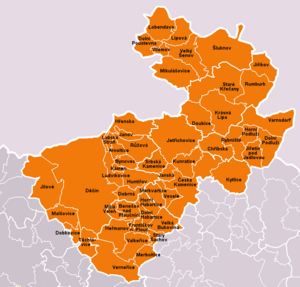
Rayon Dechin ( czech. Okres Děčín ) - District of the Ustecky Region of the Czech Republic . The administrative center is the city of Decin . The area of the district is 908.58 square meters. km., the population is 136,672 people. There are 52 municipalities in the district, of which fourteen are cities.
| Area | |
| Decin District | |
|---|---|
| Okres Děčín | |
| A country | |
| Enters into | Ustecky |
| Adm Centre | Decin |
| History and geography | |
| Square | 908.58 km² |
| Population | |
| Population | 136,672 people ( 2009 ) |
| Density | 152 p / km² |
| Digital identifiers | |
| ISO 3166-2 code | |
| Automat code numbers | DC (until 2001 ) |
 | |
 | |
Geography
Located in the northeast region. Borders on the regions of Usti nad Labem , Litomerice of the Ustetsky region; Ceska Lipa, Liberec Region . In the north - the state border with Germany .
Cities and Populations
Data for 2009 :
| City | Population |
|---|---|
| Decin | 52,614 |
| Varnsdorf | 16,094 |
| Rumburk | 11,456 |
| Shluknov | 5,735 |
| Ceska Kamenice | 5,629 |
| Yilove | 5,293 |
| Yirzhikov | 4,064 |
| Benešov nad Ploučníci | 4,052 |
| Krasna Lipa | 3,735 |
| Mikulasovice | 2,340 |
| Velky Shenov | 2,035 |
| Dolny-Poustevna | 1 958 |
| Hršibska | 1,492 |
| Verneržice | 1,121 |
| Total | Women | Men |
|---|---|---|
| 136,672 (100 %) | 68,837 (50.37%) | 67,835 (49.63%) |
The average density is 152 persons / km².