Perak ( Malaysian. Perak , Javi : ڨيرق - " silver ", similar to the color of silver tin ) - the state of Malaysia .
| state of malaysia | |||||
| Perak | |||||
|---|---|---|---|---|---|
| Malaysian Perak javi: ڨيرق | |||||
| |||||
| Negaraku | |||||
| A country | Malaysia | ||||
| Includes | 10 districts | ||||
| Adm. Centre | Ipoh | ||||
| The sultan | Nazrin Muizuddin Shah | ||||
| History and Geography | |||||
| Square | 21 005 km² (4th place ) | ||||
| Timezone | UTC + 8: 00 | ||||
| Population | |||||
| Population | 2,352,743 people ( 2010 ) ( 5th place ) | ||||
| Density | 112.01 people / km² (11th place) | ||||
| Digital identifiers | |||||
| Abbreviation | PK | ||||
| ISO 3166-2 Code | MY-08 | ||||
| Telephone code | |||||
| Postal codes | and | ||||
| Auto Code numbers | |||||
| Official site | |||||
 | |||||


Content
General information
The area of Perak State is 21,005 km². The population is 2,352,743. (for 2010). The population density is 112.01 people / km² (2010). The urban population is 58.7%. Perak is a constitutional monarchy, the sultanate . Head of state (May 29, 2014) - Sultan Nazrin Shah. The administrative center is the city of Ipoh . The Sultan's residence is located in Kuala Kangsar .
Official Symbols
The Perak flag is a rectangular panel, consisting of three horizontal equal-sized stripes: the upper one is white, the middle one is yellow, and the lower one is black. The white bar represents the ruler ( Malaysian Yang Di Per Tuan ), the yellow one represents the “younger ruler” ( Malaysian Raja Muda ) and the black one represents the first minister (ruler-treasurer of Malaysian Raja Bandahara ), who is the second successor to the throne after the “younger ruler” [1] [2] .
Geography
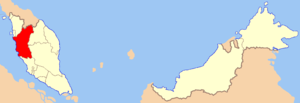
Perak is located in West Malaysia , on the west coast and in the central part of the Malay Peninsula . In the north of Perak passes the state border with Thailand ; in the north, Perak borders on the state of Kedah ; in the east - with the states of Kelantan and Pahang , in the south - with the state of Selangor . In the west, it is washed by the waters of the Strait of Malacca . The eastern border of Perak lies along the Banjaran Titivangs mountain range, in the middle part of which reaches a height of 2183 meters (Mount Korbu ). Through the entire state, from north to southwest, the Perak River flows into the Strait of Malacca. Opposite the mouth of this river, in the strait is the island of Pangkor belonging to Perak. The central and northern regions of the state are mountainous, here the Perak River in its upper reaches forms a chain of mountain lakes. In the south - marshy lowlands, densely overgrown with forests and shrubs.
The largest cities of Perak: Ipoh, Kuala Kangsar, Tapah , Kampar , Telok-Intan , Taiping .
In 1884, the world's largest tin deposit was discovered in the Perak Sultanate, in the Kint region.
History
In the XVII century, the sultanate of Perak waged lengthy wars with the Dutch , trying to gain a foothold on the Malay Peninsula. In the XVIII - early XIX century, it falls under the influence of neighboring Siam . In 1826, the British captured and turned into their colony the territory of Dindings, located in the west of Perak, on the coast of the Strait of Malacca. At the same time, they opposed the annexation of Perak by Siam. In 1848, tin mining began in the sultanate, carried out primarily by Chinese emigrants. It is accompanied by constant bloody skirmishes between gangs trying to control the mines.
In 1874, the Sultan concluded an agreement with England on Pangkor Island, according to which Perak became an English protectorate. In 1896, Perak, together with Selangor , Pahang and Negri Sembilan , form the Federation of Malaysian principalities controlled by England. In December 1941, Perak was occupied by Japanese troops , in September 1945 they were driven out by the British. In 1957, Perak became part of the independent Malaysian Federation , and in 1963 - Malaysia.
Sultans of Perak
- Muzaffar Shah I (1529-1549), the eldest son of Sultan Malacca and Johor Mahmoud Shah
- Mansur Shah I (1549-1577), son of the previous
- Ahmad Taj ad-din-shah (1577-1584), son of the previous
- Taj al-Arifin Shah (1584-1594), brother of the previous
- Alaaddin Shah (1594-1603), the grandson of Ahmad Taj ad di Shah
- Mukadam Shah (1603-1619), grandson of Ahmad Taj ad di Shah
- Mahmud Shah I (1619-1630), brother of the previous
- Mansur Shah II (1619-1627), brother of Aladdin Shah
- Salahaddin Shah (1630-1635) son of Mahmud Shah I
- Muzaffar Shah II (1635-1654), son-in-law of Mahmud Shah I
- Muhammad Iskandar Shah (1654-1720), son of the previous
- Alaaddin Riayat Shah (1720-1728), son of the previous
- Muzaffar Shah III (1728-1754), brother of the previous
- Muhammad Shah (1728-1750), brother of the previous
- Iskandar Zul-Karnain-Shah (1754-1765), son of the previous
- Mahmud Shah II (1765-1773), brother of the previous
- Alaaddin Mansur Iskandar Shah (1773-1786), brother of the previous
- Ahmadin Shah (1786-1806), brother of the previous
- Abdul-Malik Mansur Shah (1806-1825), son of the previous
- Abdallah Muazzam Shah (1825-1830), son of the previous
- Shihab ad-din Riyayat Shah (1830-1841), son of Raji Inu, grandson of Ahmadin Shah
- Abdallah Muhammad Shah I (1841-1850), son of Raja Abdul-Rahman, grandson of Ahmadin Shah
- Jafar Muazzam Shah (1850-1865), son of Rajah Ahmad, grandson of Abdul-Malik Mansur Shah
- Ali al-Kamil Riayat Shah (1865-1871), son of Shihab ad-Din Riyat Shah
- Ismail Muabidin Shah (1871-1874), son of Raji Nandak, grandson of Ahmadin Shah
- Abdallah Muhammad Shah III (1874-1876), Jafar Muazzam Shah
- Yusuf Sharif ad-din Mufzal Shah (1876-1887), son of Abdallah Muhammad Shah I
- Idris Murshid al-Azam Shah (1887-1916), son of Iskandar, grandson of Rajah Ahmad, great-grandson of Abdul-Malik Mansur Shah (1806-1825)
- Abdul-Jalil Shah (1916-1918), son of the previous
- Iskandar Shah (1918-1938), brother of the previous
- Abdul-Aziz-Shah (1938-1948), son of Raja Muda Musa, grandson of Jafar Muazzam Shah (1850-1865)
- Yusuf Izzuddin Shah (1948-1963), son of Abdul-Jalil Shah (1916-1918)
- Idris al-Mutawakkil Shah (1963-1984), son of Iskandar Shah (1918-1938)
- Tuanku Azlan Muhibuddin Shah (1985-2014), son of Yusuf Izzuddin Shah
- Nazrin Muizuddin Shah (since 2014), the eldest son of the previous one.
Administrative Division
The state is divided into 10 districts: [3]
| No. | Area | Population, people (2009) |
|---|---|---|
| one | Quinta | 846 300 |
| 2 | Larut, Matang Dan Selama | 320 100 |
| 3 | Manjung | 247,200 |
| four | Hilir Perak | 232,800 |
| five | Kerian | 196,500 |
| 6 | Batang Padang | 191 900 |
| 7 | Kuala Kangsar | 176,000 |
| eight | Perak Tengah | 116 500 |
| 9 | Hulu Perak | 114 900 |
| ten | Kampar | 98 534 |
Population
As elsewhere in Malaysia, the main 3 populations in Perak are Malays (54.7% of the total population), Chinese (32%) and Indians - 13%. Chinese emigration was quite significant already in the 15th century, however, the largest number of Chinese and Indians entered Perak at the end of the 19th century, contracted to work in tin mines and rubber plantations. Among the Chinese, people from Southeast China predominate, among the Indians, Tamils . The Chinese inhabit a fairly dense coastal strip of the state, many of them among urban residents. The largest Indian colonies in the cities of Ipo and Taiping - in terms of the number of inhabitants they are second only to the Indian colony in the capital of the country, Kuala Lumpur, in Malaysia.
In Perak, small indigenous peoples also live - the jakun , related to the tea of Thailand and the selunas of Burma , as well as hay and semanga belonging to the Malacca language group . Jakun are divided into tribes of Manther, Biduanda, Bland, Orangulu, Orangkanak and Oranglaut. Semangas, which are also several nomad tribes (Jagai, Menra, Menri, Lanoch, Bateg, Sabub) are racially short stunted Negroes . Jakun live in the upper reaches of the Perak River, hay - in the central part of the state and northeast of the city of Ito, salmon - in the Baling area on the border with Thailand.
The most densely populated coastal areas of the state, here the population density can reach 300-400 people per 1 km², as well as areas of tin mining. The mountain ranges stretching along the northwestern and eastern borders of Perak are almost completely uninhabited.
Notes
- ↑ Since 1959, the position of the first Malay minister is called Dyam Raja Di-Hilir
- ↑ Council Minutes - 1st March 1879. In: Harisson CW, ed.Papers on Malay Subjects History (Part III). Council Minutes Perak. 1877-1879. Kuala-Lumpur: Federated Malaya States Press, 1908, p. 37. cit. By: The creation of Perak State flag - 1 March 1879
- ↑ BASIC POPULATION CHARACTERISTICS BY ADMINISTRATIVE DISTRICTS (inaccessible link) . Jabatan Perangkaan Malaysia. Date of treatment November 24, 2010. Archived December 28, 2010.
Literature
- Ryzhov K.V. All monarchs of the world. Muslim East. XV — XX centuries - M .: Veche, 2004 .-- 544 p.