Koporskaya Bay ( Koporskiy Bay ) - a bay in the southern part of the Gulf of Finland of the Baltic Sea .
| Koporskaya lip | |
|---|---|
 Koporskaya Bay near the village of Mustovo | |
| Specifications | |
| Bay Type | Lip |
| Flowing rivers | Funnel , Sista , Kovashi |
| Location | |
| Upstream waters | Gulf of Finland , Baltic Sea , Atlantic Ocean |
| A country |
|
| The subject of the Russian Federation | Leningrad region |
| Area | Lomonosov district |

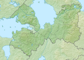
Length 12 km. Width up to 26 km. Deep-water bay - depth up to 20 m. The coast is low-lying, rocky (sometimes sandy). On the coast of the bay is a forest [1] .

On the shore is the city of Sosnovy Bor and the villages of Sisto-Palkino and Old Garkolovo . The Voronka , Kovashi and Sista rivers flow into the bay. The lip is bounded from the west by the Soikinsky Peninsula (Cape Kolganpya) and Cape Ustinsky from the east. Cape crashes into the bay: Lipunismi, Nennisari, Dubovskaya, Dolgaya, Navolok and the Khilista peninsula. In the southern part of the bay is the harbor of Peipia. Along the coast of the bay runs the highway St. Petersburg - Sosnovy Bor - Brooks [2] .
It is named after the ancient fortress of Koporye , located 12 km south of the bay [1] .
Notes
- ↑ 1 2 Koporskaya Bay // Great Soviet Encyclopedia : [in 30 vol.] / Ch. ed. A.M. Prokhorov . - 3rd ed. - M .: Soviet Encyclopedia, 1969-1978.
- ↑ Map sheet O-35-10 Bol Aspiration . Scale: 1: 100 000. Terrain condition for 1976. 1978 edition