Vasyugan - a river in Russia , flows through the territory of the Kargasoksky district of the Tomsk region , located in the south of the West Siberian Plain , the left tributary of the Ob . The river is 1082 km long, navigable at a distance of 886 km from the mouth, and the catchment area is 61,800 km². The river has a flat character, the Vasyugan basin is very boggy. It is known for the world's largest accumulation of swamps and oil and gas fields being developed. Average annual flow: 327.64 m³ / s [2] .
| Vasyugan | |
|---|---|
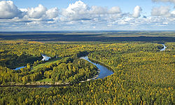 Vasyugan upstream Vasyugan upstream | |
| Characteristic | |
| Length | 1082 km |
| Swimming pool | 61 800 km² |
| Water consumption | 327.64 m³ / s (Naunak village, 63 km from the mouth) |
| Watercourse | |
| Source | Vasyugan marshes |
| • Coordinates | |
| Mouth | Ob |
| • Location | 2169 km from the mouth |
| • Coordinates | |
| Location | |
| Water system | Ob → Kara Sea |
| A country |
|
| Region | Tomsk region |
| Area | Kargasoksky district |
| HWR code | |


It originates in the swamps of the Ob-Irtysh watershed , from Vasyugan swamps . In the upper reaches of Vasyugan flows among the low marshy shores, in the floodplain there are many lakes and elders . In the middle reaches of the coast they become higher, in places up to 50 meters. In the lower reaches, the river becomes high-water, its width increases to 600 meters, and the floodplain in this section of the river becomes wide, with a large number of shallows , channels , lakes and rifts [3] .
Settlements (from the source): with. New Vasyugan , village of Aipolovo , s. New Tevriz , p. Middle Vasyugan , s. Old Birch , with. Ust-Chizhapka , s. Naunak , p. Big Mane , with. Staroyugino , s. Novoyugino , s. Cooper .
There are oil and gas fields in the Vasyugan basin.
Content
- 1 Main tributaries
- 2 Water registry data
- 3 notes
- 4 Literature
- 5 Links
Major tributaries
(km from the mouth; river lengths indicated> 50 km)
- 18 km: Slogan (length 52 km)
- 43 km: Kochebilovka
- 43 km: Passal canal
- 48 km: Naushka (length 71 km)
- 65 km: Silga (length 67 km)
- 67 km: Chebitker
- 73 km: Kinzhar duct
- 7 km: Malaya Kuletka
- 11 km: Kuletka
- 112 km: Pasil (length 76 km)
- 114 km: Chizhapka (length 511 km)
- 146 km: Kacharma
- 156 km: Winter
- 174 km: Nyurolka (length 399 km)
- 182 km: Kagaltura
- 194 km: Tunguska
- 209 km: Chebachya
- 214 km: untitled
- 230 km: Okunevka
- 237 km: Borisovskaya duct
- 246 km: Jokhomjah (length 94 km)
- 249 km: Lulia (Lulsky Chvor)
- 267 km: Vasasulya
- 271 km: Waringjögan (length 89 km)
- 285 km: untitled
- 295 km: Kedrovka (length 13 km)
- 307 km: Martynovka (length 90 km)
- 317 km: Taiga
- 324 km: Inkpoch
- 331 km: Penorovka (length 118 km)
- 342 km: Kedrovka (length 132 km)
- 362 km: Polovinka watercourse (Khlamnaya channel)
- 386 km: Kalganak
- 398 km: Yershovka
- 402 km: Makhnya (length 211 km)
- 422 km: Pond
- 437 km: Cheremshanka (length 64 km)
- 452 km: Katylga (length 120 km)
- 464 km: Zyryan-Peh
- 477 km: Half
- 492 km: Aspen
- 504 km: Cash
- 505 km: Lontinjakh (length 135 km)
- 517 km: Kelvat (length 199 km)
- Ankantsiga
- Ai-Pyoh
- 533 km: Mostnaya
- 538 km: Koksipyokh
- 566 km: Olenevka (length 68 km)
- 579 km: Perching
- 607 km: Egolyakh (length 184 km)
- 636 km: Yagylyakh (length 368 km)
- 652 km: Chertala (length 311 km)
- 661 km: Yershovka
- 722 km: Lame
- 732 km: Bolotnaya
- 736 km: Deaf
- 744 km: Kuzyr
- 767 km: Pernaya
- 782 km: Burbot
- 799 km: Sable
- 800 km: Mangushnaya
- 826 km: Kyn (length 71 km)
- 853 km: Beryozovka
- 864 km: Garchak
- 875 km: Petryak (length 56 km)
- 890 km: Staritsa
- 891 km: Elizarovka
- 896 km: Cow
- 910 km: Listvyka
- 939 km: Big Petryak (length 81 km)
- 957 km: Vankina River
- 982 km: untitled
- 994 km: Cortants
- 1013 km: Pykhtyneigay
- Yarunigay
- Yultoigay
Water registry data
According to the state water register of Russia, it belongs to the Verkhneobsky basin district , the water sector of the river is Vasyugan, the river sub-basin of the river is Vasyugan. River basin - (Upper) Ob until the confluence of the Irtysh [4] .
Notes
- ↑ Surface Water Resources of the USSR: Hydrological Understanding. T. 15. Altai and Western Siberia. Vol. 2. Average Ob / ed. V.V. Seeberg. - L .: Gidrometeoizdat, 1967 .-- 351 p.
- ↑ Vasyugan At Naunak . R-Arcticnet V4.0 . Date of treatment March 16, 2015.
- ↑ Surface Water Resources of the USSR: Hydrological Understanding. T. 15. Altai and Western Siberia. Vol. 2. Average Ob / Ed. V.V. Seeberg. - L .: Gidrometeoizdat, 1967.S. 31 .-- 351 p.
- ↑ State Water Register . Vasyugan . textual.ru . Ministry of Natural Resources of Russia (March 29, 2009). Date of treatment December 20, 2018. Archived March 29, 2009.
Literature
- Evseeva N. S. Geography of the Tomsk region (Natural conditions and resources) . - Tomsk: Publishing house of Tomsk University, 2001. - 223 p. - 5,000 copies. - ISBN 5-7511-1930-X (wrong)
- Encyclopedic Geographic Dictionary: Geographic Names / Ch. Ed. A. F. Treshnikov; Ed. col .: E. B. Alaev, P. M. Alampiev, A. G. Voronov and others. - M .: Sov. Encyclopedia, 1983.- S. 82.- 538 p. - 100,000 copies.
Links
- Vasyugan // Great Soviet Encyclopedia : [in 30 vol.] / Ch. ed. A.M. Prokhorov . - 3rd ed. - M .: Soviet Encyclopedia, 1969-1978.