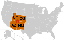


Four corners , eng. Four Corners is a US region that occupies the territory of southwestern Colorado , northwestern New Mexico , northeastern Arizona and southeastern Utah . The name is associated with the Monument of the Four Corners located at the border of four states (the only such border crossing in the United States, but not the only one in North America ).
Not far from the Monument to the four corners, the USRoute 160 trunk highway runs from which the short local road of the State of New Mexico NM 597 , which is only 0.45 miles long (720 m), leads directly to the monument. To the northeast of the Monument, at a distance of about a kilometer from it, the San Juan River (a tributary of the Colorado) flows.
The majority of the population of the region of the four corners are semi-autonomous Indian peoples. The boundaries of two of the reservations - Navajo and Utes - are at the Monument of the four corners. The economic capital of the region is the city of Farmington in the state of New Mexico .