Akhtuba (tat. Ak-tyube - white hill [2] ) is the left arm of the Volga , which separates from it opposite the northern part of Volgograd . The old entrance to Akhtuba, which was located upstream, during the construction of the Volga Hydroelectric Power Station was blocked by its dam, but a canal 6.5 km long was dug below.
| Akhtuba | |
|---|---|
 Akhtuba Akhtuba | |
| Characteristic | |
| Length | 537 km |
| Water consumption | 153 m³ / s |
| Watercourse | |
| Source | Volga |
| • Location | Volzhsky city |
| • Coordinates | |
| Mouth | Busan |
| • Location | with. Krasny Yar (Astrakhan region) |
| • Coordinates | |
| Location | |
| Water system | Buzan → Volga → Caspian Sea |
| A country |
|
| Regions | Volgograd region , Astrakhan region |
| HWR code | |
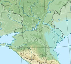
The length of Akhtuba is 537 km. The average annual flow rate is 153 m³ / s. The following cities are located on Akhtuba: Volzhsky (at the beginning of the sleeve), Leninsk , Znamensk , Akhtubinsk , Kharabali (5 km from the river). Between the Volga and Akhtuba there is the Volga-Akhtuba floodplain , which is a region of melon growing and vegetable growing. Before the construction of the cascade of hydroelectric power stations, the width of the spills within this floodplain reached 20-30 km.
The river bed reaches a width of 200, and in some places 300 meters, and in some places the width is no more than 50 meters. In floods (April-May), the flow rate increases, and slows down towards its end. In some places Akhtuba is bottled and shallow. In deep places throughout Akhtuba and the channels good fishing. Vast fields and melons are located in the northern part on the left bank; water intake stations supplying water to the fields are often found.
Gallery
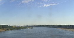
Akhtuba River and Volga-Akhtuba floodplain near Volzhsky
The bridge over Akhtuba. Natural Park "Volga-Akhtubinskaya floodplain", Volgograd region
Spring flood on Akhtuba
Akhtuba River in the middle course
Notes
- ↑ Surface Water Resources of the USSR: Hydrological Understanding. T. 12. Lower Volga and Western Kazakhstan. Vol. 1. Lower Volga / ed. O. M. Zubchenko. - L .: Gidrometeoizdat, 1966 .-- 287 p.
- ↑ Akhtuba // Brockhaus and Efron Encyclopedic Dictionary : in 86 volumes (82 volumes and 4 additional). - SPb. , 1890-1907.
Links
- Akhtuba // Great Soviet Encyclopedia : [in 30 vol.] / Ch. ed. A.M. Prokhorov . - 3rd ed. - M .: Soviet Encyclopedia, 1969-1978.
- Akhtuba // Dictionary of modern geographical names / Rus. geo about . Mosk. Centre; Under the total. ed. Acad. V.M. Kotlyakova . Institute of Geography RAS . - Yekaterinburg: U-Factoria, 2006.
- Akhtuba // Brockhaus and Efron Encyclopedic Dictionary : in 86 volumes (82 volumes and 4 additional). - SPb. , 1890-1907.