Debossky district ( Udm. Debes росros ) is an administrative-territorial unit and municipality ( municipal district ) in the Udmurt Republic of the Russian Federation .
| Municipal District | |||||
| Deboss district | |||||
|---|---|---|---|---|---|
| Debes Eros | |||||
| |||||
| A country | |||||
| Included in | Udmurt republic | ||||
| Includes | 10 municipalities | ||||
| Adm. center | village Debosy | ||||
| Head of the district | Glukhov Alexander Leonidovich | ||||
| The head of administration | Ivanov Andrey Serafimovich | ||||
| History and Geography | |||||
| Date of formation | July 15, 1929 | ||||
| Area | 1033.03 [1] km² (20th place ) | ||||
| Timezone | MSK + 1 ( UTC + 4 ) | ||||
| Population | |||||
| Population | ↘ 12 073 [2] people ( 2017 ) (0.8%, 19th place ) | ||||
| Density | 11.69 people / km² (13th place) | ||||
| Nationalities | Udmurts, Russians, Tatars | ||||
| official languages | Russian , Udmurt | ||||
| Digital identifiers | |||||
| Telephone code | 34151 | ||||
| Official site | |||||


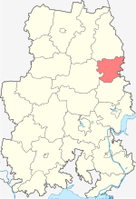

Located in the eastern part of the republic. The administrative center is the village of Debesy .
Content
- 1 Geographical location
- 2 History
- 3 population
- 4 Administrative divisions
- 4.1 Settlements
- 5 Local government
- 5.1 Symbols of the area
- 5.2 District budget
- 6 Social infrastructure
- 7 Economics
- 8 People associated with the area
- 9 notes
- 10 Links
Geographical position
The area is located in the eastern part of the republic and borders on the Kez district in the north, Igrinsky district in the west, Sharkan district in the south and Perm region in the east. In the center of the district, from the east to the west, the Cheptsa River flows - the largest river in the north of Udmurtia. The northern part of the region is located on the Verkhnekamsk Upland , and the south - on the Tylovay Upland [3] . In addition to Cheptsa, its tributaries - Ita , Pihta , Medlo , Il , Irymka and many others - flow through the territory of the district.
The forest cover of the region is 36.4%, while the average for Udmurtia is 46.8% [4] .
History
The district was formed on July 15, 1929 from 20 village councils of Debosskaya and Polomskaya volosts of the Glazovsky district and the Tylovay volost of Izhevsky district [5] .
In 1935, the newly formed Tylovaysky district was allocated from the district [6] .
In 1956, in connection with the abolition of the Zurinsky and Tylovaysky districts, part of their village councils were transferred to it [7] .
From 1962 to 1965, the district was temporarily abolished and its village councils were part of the Kez rural region [8] .
As a result of the municipal reform, since January 1, 2006 it has been given the status of a municipal district.
Population
| Population size | |||||
|---|---|---|---|---|---|
| 1959 [9] | 1970 [10] | 1979 [11] | 1989 [12] | 2002 [13] | 2009 [14] |
| 21 336 | ↘ 17 865 | ↘ 15 029 | ↘ 13 981 | ↗ 14 085 | ↘ 13 679 |
| 2010 [15] | 2011 [16] | 2012 [17] | 2013 [18] | 2014 [19] | 2015 [20] |
| ↘ 12 665 | ↘ 12 636 | ↘ 12 615 | ↘ 12 472 | ↘ 12 283 | ↘ 12 178 |
| 2016 [21] | 2017 [2] | ||||
| ↘ 12 112 | ↘ 12 073 | ||||
According to the 2002 census , 14,085 people lived in the district [22] , 2010 census - 12,665 people [23] , between the censuses the population of the region decreased by 11.21%. Of the total population of the district, 45.16% of the population lived in the district center of the village of Debesy . The average population density is 12.26 people / km². The district occupies the 19th place in population and the 13th place in density among the municipal districts of Udmurtia. As of January 1, 2013, out of 61 settlements of the district, 4 did not have a resident population [24] .
In 2011, the birth rate was 19.9 ‰, the mortality rate was 15.6 ‰, the natural population growth was 4.3 ‰, and the average for Udmurtia was 1.0 ‰. In 2011, the migration loss of the population was 77 people (the difference between the number of departures and arrivals in the district) [25] .
- National composition
According to the results of the 2002 census , among the population of the region, Udmurts accounted for 79%, Russians - 19.7% [26] . Debossky district is one of 16 rural areas of the republic, where the Udmurts make up the majority.
Administrative Division
In the Debossky district as an administrative-territorial unit includes 10 village councils [27] [28] . Village councils (rural administrations) are of the same name as rural settlements formed within their borders [29] .
The municipal district includes 10 municipalities with the status of rural settlements [30] .
| No. | Rural settlement | Administrative center | amount populated points | Population | Area, Km 2 |
|---|---|---|---|---|---|
| one | Bolshezetymskoe | Big Zetym village | 6 | ↗ 510 [2] | 51.77 [1] |
| 2 | Deboss | village Debosy | 2 | ↗ 6168 [2] | 55.79 [1] |
| 3 | Zarechnomedlinskoe | Zarechnaya Medla village | 5 | ↘ 1051 [2] | 111.99 [1] |
| four | Kotegurt | Kotegurt village | 3 | ↘ 315 [2] | 55.90 [1] |
| 5 | Nizhnepykhtinskoe | Nizhnyaya Pykhta village | 7 | ↘ 630 [2] | 179.16 [1] |
| 6 | Starokych | Stary Kych village | 10 | ↘ 825 [2] | 139.25 [1] |
| 7 | Syurnogurt | village of Syurnogurt | 6 | ↘ 764 [2] | 105.15 [1] |
| 8 | Tolyenskoe | village Debosy | eleven | ↘ 790 [2] | 169.04 [1] |
| 9 | Tylovayskoye | Tylovay village | 5 | ↘ 681 [2] | 71.37 [1] |
| 10 | Uyvaiskoe | Uyvay village | 6 | ↘ 339 [2] | 93.61 [1] |
Settlements
Debossky district includes 61 settlements.
| List of settlements of the district | ||||
|---|---|---|---|---|
| No. | Locality | Type of | Population | Rural settlement |
| one | Anyashur | village | ↗ 40 [31] | Starokych |
| 2 | Arikovo | village | ↘ 180 [31] | Nizhnepykhtinskoe |
| 3 | Badzimoshur | village | ↗ 67 [31] | Syurnogurt |
| four | Birch | village | ↗ 49 [31] | Tolyenskoe |
| 5 | Bibangurt | village | → 0 [31] | Bolshezetymskoe |
| 6 | Big Kiznya | village | ↘ 167 [31] | Zarechnomedlinskoe |
| 7 | Big Cap | village | → 69 [31] | Nizhnepykhtinskoe |
| 8 | Big Zeta | village | ↘ 309 [31] | Bolshezetymskoe |
| 9 | Vanya Chumo | village | ↘ 8 [31] | Tolyenskoe |
| 10 | Varney | village | ↗ 222 [31] | Tolyenskoe |
| eleven | Upper Sylyz | village | → 0 [31] | Bolshezetymskoe |
| 12 | Upper Chetker | village | ↘ 115 [31] | Starokych |
| 13 | Upper Shujalud | village | ↘ 45 [31] | Tylovayskoye |
| fourteen | Gordyar | village | → 0 [31] | Kotegurt |
| fifteen | Deboobs | village | ↗ 5778 [31] | Deboss |
| 16 | Jilia | village | ↘ 62 [31] | Starokych |
| 17 | Apartment Buildings Brick Factory | village | ↘ 100 [31] | Bolshezetymskoe |
| eighteen | Zarechnaya Medla | village | ↘ 560 [31] | Zarechnomedlinskoe |
| 19 | Ivana | village | ↘ 6 [31] | Uyvaiskoe |
| twenty | Irym | village | ↗ 143 [31] | Syurnogurt |
| 21 | Kejia | village | ↘ 38 [31] | Starokych |
| 22 | Mosquitoes | village | ↘ 60 [31] | Nizhnepykhtinsk |
| 23 | Kosolyuk | village | ↘ 60 [31] | Kotegurt |
| 24 | Cotegurt | village | ↗ 296 [31] | Kotegurt |
| 25 | Koteshur | village | ↘ 32 [31] | Starokych |
| 26 | Levangurt | village | ↘ 1 [31] | Bolshezetymskoe |
| 27 | Legomyvyr | village | ↘ 45 [31] | Uyvaiskoe |
| 28 | Lesagurt | village | → 173 [31] | Tolyenskoe |
| 29th | Lobans | village | ↗ 1 [31] | Nizhnepykhtinskoe |
| thirty | Little Kiznya | village | ↘ 18 [31] | Zarechnomedlinskoe |
| 31 | Small Cap | village | ↗ 249 [31] | Deboss |
| 32 | Small Zeta | village | ↘ 123 [31] | Bolshezetymskoe |
| 33 | Markovo | village | ↘ 14 [31] | Uyvaiskoe |
| 34 | Nagovitsyno | village | ↗ 37 [31] | Syurnogurt |
| 35 | Lower Rear | village | ↘ 133 [31] | Tylovayskoye |
| 36 | Lower Shujjalud | village | ↘ 110 [31] | Starokych |
| 37 | Lower Puff | village | ↘ 278 [31] | Nizhnepykhtinskoe |
| 38 | New Siri | village | ↘ 2 [31] | Tolyenskoe |
| 39 | Nurovay | village | ↘ 51 [31] | Syurnogurt |
| 40 | Orekhovo | village | ↘ 7 [31] | Starokych |
| 41 | Porturnes | village | → 0 [31] | Tolyenskoe |
| 42 | Rogotnevo | village | ↘ 37 [31] | Nizhnepykhtinskoe |
| 43 | Senkagurt | village | ↘ 19 [31] | Tolyenskoe |
| 44 | Smolniki | village | ↘ 53 [31] | Syurnogurt |
| 45 | Old Zyanogurt | village | ↗ 40 [31] | Uyvaiskoe |
| 46 | Old Kych | village | ↘ 189 [31] | Starokych |
| 47 | Surrogate | village | ↗ 530 [31] | Syurnogurt |
| 48 | Takagurt | village | ↘ 294 [31] | Starokych |
| 49 | Tolien | village | ↗ 270 [31] | Tolyenskoe |
| fifty | Tolensky | fix | → 0 [31] | Tolyenskoe |
| 51 | Turnes | village | ↗ 94 [31] | Tolyenskoe |
| 52 | Rear | village | ↘ 482 [31] | Tylovayskoye |
| 53 | Udmurt Lem | village | ↗ 241 [31] | Zarechnomedlinskoe |
| 54 | Woo | village | ↘ 307 [31] | Uyvaiskoe |
| 55 | Uyvay-Medla | village | ↘ 133 [31] | Zarechnomedlinskoe |
| 56 | Urdumoshur | village | ↘ 96 [31] | Tylovayskoye |
| 57 | Ust-Medla | village | ↘ 64 [31] | Nizhnepykhtinskoe |
| 58 | Chepyk | village | ↗ 70 [31] | Tolyenskoe |
| 59 | Suralud | village | ↗ 12 [31] | Starokych |
| 60 | Yagwai | village | ↗ 19 [31] | Uyvaiskoe |
| 61 | Yagvukovo | village | ↘ 17 [31] | Tylovayskoye |
Local government
State power in the region is carried out on the basis of the Charter, the structure of local government of the municipal district is [32] [33] :
- The District Council of Deputies is a representative body of local self-government, consisting of 30 deputies, and is elected every 5 years.
- The head of the municipality is the highest official of the district, elected by the Council from among its members. The position of the Head of the district is occupied by Alexander Glukhov.
- The administration of the municipality is the executive-administrative body of the municipal district. The head of the district administration is appointed by the Council based on the results of the competition. The position of the Head of the District Administration is occupied by Andrey Ivanov Serafimovich Ivanov.
Area Symbols
The official symbols of the municipal district are the coat of arms and flag, reflecting historical, cultural, national and other local traditions and features [33] .
District Budget
Execution of the consolidated budget of the district for 2009 [34] :
- Revenues - 312.1 million rubles, including own revenues - 24.7 million rubles (7.9% of revenues).
- Costs - 324.2 million rubles. The main expense items: housing and communal services - 45.5 million rubles, education - 159.1 million rubles, culture - 25.5 million rubles, health care - 21.2 million rubles, social policy - 18.4 million rubles.
Social Infrastructure
The education system of the district includes 15 schools, including 5 secondary, an art school and 17 kindergartens. 2 public health institutions and 23 feldsher-midwife stations provide medical assistance to the population. There are also 24 rural clubs and club institutions, 17 libraries and a museum (including 2 branches) in the district [35] .
Economics
People associated with the area
- Yaroslavtsev, Alexander Egorovich - Hero of the Soviet Union
Notes
- ↑ 1 2 3 4 5 6 7 8 9 10 11 Republic of Udmurtia. The total land area of the municipality
- ↑ 1 2 3 4 5 6 7 8 9 10 11 12 The population of the Russian Federation by municipalities as of January 1, 2017 (July 31, 2017). Date of treatment July 31, 2017. Archived July 31, 2017.
- ↑ Udmurt Republic: Encyclopedia / Ch. ed. V.V. Tuganaev . - Izhevsk: Udmurtia , 2000 .-- S. 14. - 800 p. - 20,000 copies. - ISBN 5-7659-0732-6 .
- ↑ Developed by Lesproekt LLC in conjunction with the Federal State-Funded Educational Institution of Higher Professional Education Izhevsk State Agricultural Academy with the consulting support of the Roslesinforg branch of the Federal State Unitary Enterprise - Povolzhsky Lesproekt. Forest Plan of the Udmurt Republic . - Izhevsk, 2010 .-- S. 33. - 260 p. (inaccessible link)
- ↑ Directory of the administrative-territorial division of Udmurtia / Compiled by O. M. Beznosova, S. T. Derendyaev, A. A. Korolev. - Izhevsk: Udmurtia, 1995 .-- S. 129. - 744 p. - 2000 copies. - ISBN 5-7659-0425-4 .
- ↑ Directory of the administrative-territorial division of Udmurtia / Compiled by O. M. Beznosova, S. T. Derendyaev, A. A. Korolev. - Izhevsk: Udmurtia, 1995 .-- S. 272. - 744 p. - 2000 copies. - ISBN 5-7659-0425-4 .
- ↑ Directory of the administrative-territorial division of Udmurtia / Compiled by O. M. Beznosova, S. T. Derendyaev, A. A. Korolev. - Izhevsk: Udmurtia, 1995 .-- S. 275-276. - 744 p. - 2000 copies. - ISBN 5-7659-0425-4 .
- ↑ Directory of the administrative-territorial division of Udmurtia / Compiled by O. M. Beznosova, S. T. Derendyaev, A. A. Korolev. - Izhevsk: Udmurtia, 1995 .-- S. 277. - 744 p. - 2000 copies. - ISBN 5-7659-0425-4 .
- ↑ 1959 All-Union Census of the Population . Date of treatment October 10, 2013. Archived October 10, 2013.
- ↑ 1970 All-Union Census. The current population of cities, urban-type settlements, districts, and regional centers of the USSR according to the census as of January 15, 1970, in the republics, territories, and regions . Date of treatment October 14, 2013. Archived October 14, 2013.
- ↑ All-Union Census of 1979
- ↑ All-Union Population Census of 1989 . Archived August 23, 2011.
- ↑ 2002 All-Russian Population Census. Tom. 1, table 4. The population of Russia, federal districts, constituent entities of the Russian Federation, regions, urban settlements, rural settlements - district centers and rural settlements with a population of 3 thousand or more . Archived February 3, 2012.
- ↑ The number of permanent population of the Russian Federation by cities, urban-type settlements and districts as of January 1, 2009 . Date of treatment January 2, 2014. Archived January 2, 2014.
- ↑ Results of the 2010 All-Russian Population Census. 5. The population of Russia, federal districts, constituent entities of the Russian Federation, districts, urban settlements, rural settlements - district centers and rural settlements with a population of 3,000 or more . Date of treatment November 14, 2013. Archived November 14, 2013.
- ↑ Udmurtia. Estimation of the population as of January 1 of the current year 2009-2015
- ↑ Population of the Russian Federation by municipalities. Table 35. Estimated resident population as of January 1, 2012 . Date of treatment May 31, 2014. Archived May 31, 2014.
- ↑ The population of the Russian Federation by municipalities as of January 1, 2013. - M.: Federal State Statistics Service of Rosstat, 2013. - 528 p. (Table 33. The population of urban districts, municipalities, urban and rural settlements, urban settlements, rural settlements) . Date of treatment November 16, 2013. Archived November 16, 2013.
- ↑ Table 33. The population of the Russian Federation by municipalities as of January 1, 2014 . Date of treatment August 2, 2014. Archived on August 2, 2014.
- ↑ The population of the Russian Federation by municipalities as of January 1, 2015 . Date of treatment August 6, 2015. Archived on August 6, 2015.
- ↑ Population of the Russian Federation by municipalities as of January 1, 2016
- ↑ Federal State Statistics Service. 2002 census. The population of Russia, federal districts, constituent entities of the Russian Federation, districts, urban settlements, rural settlements - regional centers and rural settlements with a population of 3 thousand or more people . Date of treatment May 21, 2013. Archived May 23, 2013.
- ↑ Federal State Statistics Service. 2010 census. The population of Russia, federal districts, constituent entities of the Russian Federation, districts, urban settlements, rural settlements - regional centers and rural settlements with a population of 3 thousand or more people . Date of treatment May 21, 2013. Archived May 23, 2013.
- ↑ Federal State Statistics Service. The number of administrative-territorial units and municipalities as of January 1, 2013 in the Udmurt Republic . Date of treatment May 21, 2013. Archived May 23, 2013.
- ↑ Ministry of Economics of the Udmurt Republic. Brief socio-economic passport of the Debessky district (2012). Date of treatment May 29, 2013. Archived on May 30, 2013.
- ↑ Debossky district (inaccessible link) . Office of the Chief Federal Inspector for the Udmurt Republic. Date of treatment January 9, 2010. Archived May 18, 2008.
- ↑ Law "On the administrative-territorial structure of the Udmurt Republic"
- ↑ Constitution of the Udmurt Republic
- ↑ The number of administrative-territorial units and municipalities as of January 1, 2016 in the Udmurt Republic
- ↑ Law of the Udmurt Republic of July 14, 2005 No. 45-РЗ “On Establishing the Boundaries of Municipalities and Giving the corresponding Status of Municipalities on the Territory of the Debossky District of the Udmurt Republic”
- ↑ 1 2 3 4 5 6 7 8 9 10 11 12 13 14 15 16 17 18 19 20 21 22 23 24 25 26 27 28 29 30 31 32 33 34 35 36 37 38 39 40 41 42 43 44 45 46 47 48 49 50 51 52 53 54 55 56 57 58 59 60 61 The catalog of settlements of the Udmurt Republic. The number of resident population on January 1, 2012 . Date of treatment March 24, 2015. Archived March 24, 2015.
- ↑ FZ-131 “On the General Principles of the Organization of Local Self-Government in the Russian Federation” (Inaccessible link) . Date of treatment May 11, 2013. Archived March 4, 2016.
- ↑ 1 2 Charter of the Debossky District municipality (Inaccessible reference - history ) (as amended by the decisions of the Debessky District Council of Deputies dated May 26, 2006 No. 24, dated February 14, 2007 No. 1, the Council of Deputies of the Debesky Municipality district ”dated May 29, 2008 No. 27, dated April 23, 2009 No. 21, dated November 19, 2009 No. 50, dated August 18, 2010 No. 23, dated April 28, 2011 No. 16, dated November 25, 2011 No. 57, dated May 4, 2012 No. 33 ) Date of treatment May 29, 2013.
- ↑ Execution of the consolidated budget of the district for 2009 (Inaccessible link - history ) . State Council of UR. Date of treatment June 1, 2010.
- ↑ Social institutions . State Council of UR. Date of treatment January 20, 2010. Archived March 25, 2012.
Links
- Debossky district on the website of the State Council of the UR (Inaccessible link) . Archived on May 16, 2011.