The mouth is a river in the Yaroslavl region of Russia. Length - 153 kilometers, basin area 2530 km², average water flow 42 km from the mouth 10.3 m³ / s
| Mouth | |
|---|---|
 The mouth in the village. Semibratovo (bridge - federal highway M8 Moscow — Yaroslavl — Arkhangelsk ) The mouth in the village. Semibratovo (bridge - federal highway M8 Moscow — Yaroslavl — Arkhangelsk ) | |
| Characteristic | |
| Length | 153 km |
| Pool | 2530 km² |
| Water consumption | 10.3 m³ / s |
| Watercourse | |
| Source | |
| • Location | Uglich district of Yaroslavl region |
| • Coordinates | |
| Mouth | Kotorosl |
| • Coordinates | |
| Location | |
| Water system | Kotorosl → Gorky reservoir → Volga → Caspian Sea |
| A country |
|
| Region | Yaroslavskaya oblast |
| HWR code | |
Description
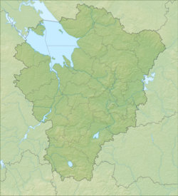
The river flows from the swamp s. Zaozerye of the Uglich region . Initially, it flows eastward along the territory of modern Borisoglebsky and Rostov regions . Near the village of Semibratovo, it abruptly turns south and around s. Nikolo-Perevoz merges with the river. Vyoksoy , forming the Kotorosl River.
The width of the channel varies from 10 to 40 m, the depth from 0.2 to 2 m. [2] The Ustye River in its course crosses several geomorphological regions, as if descending from the overlying high-level steps to the lower ones. This explains the rapid course and the whimsical nature of the wandering of the channel, which is continuously bent, often branching into sleeves and forming middle and floodplain islands.
Along the banks - on the terraces and the hills of the river, ripe dry (white-moss, lichen and heather ) picturesque pine trees have been preserved.
The river has five main tributaries, with a length of more than 20 km, these are: p. Lut - 20 km, p. Mogza - 84 km, p. Shula - 25 km, river League - 31 km, p. Ilma - 32 km. Ten tributaries with a length of 10 to 20 km are Naritsa , Pura , Lehta , Laskovka , Derinochka , Talitsa , Zvenich , Inbozhka , Gorda , Bolzhbin and about 42 tributaries of less than 10 km. [2]
On the river there are urban settlements Borisoglebsky and Semibratovo .
Major tributaries
(distance from the mouth)
- 15 km: Lut river (lv)
- 19 km Suma (ave)
- 24 km: river Mogza (Mokza) (lv)
- 32 km: Pura river (lv)
- 43 km: river Shula (pr)
- 67 km: river Liga (pr)
- 87 km: Lehta river (lv)
- 89 km: a river without a name, at s. Hills (lv)
- 100 km: Ilma river (pr)
- 101 km: Derinochka River (lv)
- 114 km: Ivrovka river (lv)
- 116 km Porechenka river (pr)
- 119 km: Talitsa river (pr)
- 125 km Chursovka river (lv)
- 127 km Veksa River (ave)
- 133 km: Zvenikha River ( Bortinka ) (lv)
- 139 km Inalivka river (lv)
- 141 km Nibozhka river (lv)
- 142 km Gorda River (ave)
- 144 km: river Bolzhbina (pr)
Notes
- ↑ Surface Water Resources of the USSR: Hydrological Understanding. T. 10. Upper Volga region / ed. V.P. Shaban. - L .: Gidrometeoizdat, 1966 .-- 528 p.
- ↑ 1 2 Report on the results of the express expedition of the lower reaches of the river. Estuary (in PDF format ) . www.volga-centre.ru . Date of appeal April 27, 2019.