Al-Ghazal [1] [2] ( Arabic. بحر الغزال , Bahr al-Ghazal ) is a river in South Sudan , the left tributary of the White Nile .
| Ghazal | |
|---|---|
| Arab. بحر الغزال | |
| Characteristic | |
| Length | 716 km |
| Pool | 520,000 km² |
| Watercourse | |
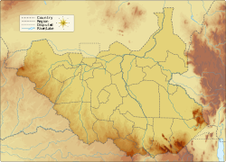
| Source | river confluence: Jur and El Arab |
| • Location | Border of South Sudan and Congo , Yambio |
| • Coordinates | |
| Mouth | White nile |
| • Coordinates | |
| Location | |
| Water system | White Nile → Nile → Mediterranean Sea |
| A country |
|
The name translates as "River of gazelles ." Formed by the confluence of the Jur and El-Arab rivers. It was first marked on the map in 1772 by the French geographer Jean Baptist d'Anville ( French: Jean-Baptiste Bourguignon d'Anville ). Navigable from the confluence of the aforementioned rivers (during the summer rains from the city of Wau on the Dzhur River).

Notes
- ↑ El-Ghazal // Dictionary of geographical names of foreign countries / resp. ed. A.M. Komkov . - 3rd ed., Revised. and add. - M .: Nedra , 1986.- S. 444.
- ↑ Northeast Africa // Atlas of the World / comp. and preparation. to the ed. PKO "Cartography" in 1999; open Ed .: T.G. Novikova , T.M. Vorobyova . - 3rd ed., Eras., Fr. in 2002 with diaposes. 1999 - M .: Roskartografiya, 2002. - S. 184-185. - ISBN 5-85120-055-3 .