Vieringen ( niderl. Wieringen ) - a community in North Holland .
| Community | |||||
| Viringen | |||||
|---|---|---|---|---|---|
| niderl. Wieringen | |||||
| A country | |||||
| Included in | province of north holland | ||||
| Adm. Centre | Hippolytushoof | ||||
| History and Geography | |||||
| Date of Abolition | 2012 | ||||
| Square | 26.77 km² | ||||
| Timezone | +1 | ||||
| Population | |||||
| Population | 8616 people ( 2010 ) | ||||
| Density | 322 people / km² | ||||
| Official language | Dutch | ||||
| Digital identifiers | |||||
| Postal codes | 1777-1779 | ||||
| Official site | |||||
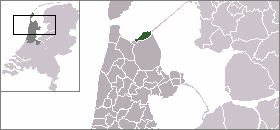 | |||||
The territory of the community covers the territory of the former island of the same name and drained lands .
The population of the community is 8668 people (2008), living on the territory of 26.77 km² (with a water surface the area is 212.5 km²).
In the south, Viringen borders on the Veringermer community, in the west - on the Anna Polona community. In the north-east of Viringen, the Afsleitdeyk Dam was built, connecting the city with the community of Vonceradel ( Friesland ). Through the Gulf of Wadden Sea to the northwest is the island of Texel .
In 2012, the community became part of the new Dutch Krone community.
See also
- Veringen