Obol ( Belor. Obal ) is a river in the Vitebsk region of Belarus , the right tributary of the Western Dvina .
| Obol | |
|---|---|
| Belor. Obal | |
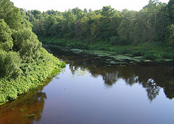 Obol in the area of Shumilino Obol in the area of Shumilino | |
| Characteristic | |
| Length | 148 km |
| Swimming pool | 2690 km² |
| Water consumption | 19.4 m³ / s (at the mouth) |
| Watercourse | |
| Source | Jezerische |
| • Height | 165.3 m |
| • Coordinates | |
| Mouth | Western Dvina |
| • Height | 109.2 m |
| • Coordinates | |
| River slope | 0.4 m / km |
| Location | |
| Water system | Western Dvina → Baltic Sea |
| A country |
|
| Region | Vitebsk region |

Content
- 1 General
- 2 Description
- 3 Hydrography
- 4 Flora and fauna
- 5 Archaeological sites
- 6 Gallery
- 7 notes
- 8 Literature
General information
The length of the river is 148 km. The catchment area is 2690 km². The average annual water flow at the mouth is 19.4 m³ / s. The average slope of the water surface is 0.4 m / km. [one]
The height of the mouth is 109.2 m above sea level [2] . The height of the source is 165.3 m above sea level [3] .
On the river are the urban village of Obol , Klyuchegorsk reservoir , Klyuchegorsk hydroelectric station (abandoned), villages Konovalovo, Vesnitsky, Proletarsk, Kozyany, Zaobol and others.
Description
It flows from Lake Ezerishche near the urban village of Ezerishche , flows through the Gorodok and Shumilinsky districts within the north-western part of the Gorodok Upland and the north-eastern part of the Polotsk Lowland . The mouth is 1 km southwest of the village Novye Gorany of the Polotsk region . The river is regulated by the Kluchegorsk reservoir. The highest flood level near the Obolka urban sprout in the 1st decade of April, the average height above the low water is 4.6 m, the highest is 7.3 m (1956). It freezes at the end of the 1st decade of December, ice drift in early April. Spring ice drift 4 days. [one]
Hydrography
The valley is mainly trapezoidal, 300–600 m wide (the largest 2.5 km, between the villages of Malaya Teshava and Konovalovo of the Gorodok district); upstream inexpressive. The floodplain is bilateral, alternating along the banks, sometimes absent; its width at the confluence of the Pig River is 400-800 m, below 100-200 m. The channel is winding, 8-20 m wide in the upper reaches, 20-40 m on average, 25-30 m in the lower. [1] The density of the river network is 0.42 km / km².
Main tributaries:
- Right : Pig , Price , Lump .
- Left : Chernivka , Chernivka , Chernivka , Odritsa , Mustache , Conscience .
The river flows through Lake Obol . In the Oboli basin there are also lakes Kosho , Bernovo , Chernovo , Osmota, Pig, Big White, Zhoden , Verino and others.
Flora and fauna
The river is inhabited by pike , perch , tench , roach , silver bream , ide , rudd , burbot , chub , gudgeon , bleak , catfish. Eel is found. In silty places and adjacent drainage channels - loach .
Aquatic vegetation: white water lily , egg capsule , reed , reeds, etc.
Archaeological sites
On the left bank of the river, 1 km west of the village of Kiseli, there is a VIII-X century fortification. It is located on top of an elongated arcuate hill (local name Pristan , Belor. Pristan ). It was investigated in 1972-1975. G.V. Shtykhov and in 1981, O.N. Levko.
Gallery
Near the village of Ivanovka. Gorodok district.
In the village of Proletarsk of the Gorodok district. April 2010
Notes
- ↑ 1 2 3 Belarus black book: Etsiklapedyya / redkal: N. A. Dzisko i insh. - Minsk: BelEn , 1994. - S. 275. - 10,000 copies. - ISBN 5-85700-133-1 . (belor.)
- ↑ Map sheet N-35-23 Obol . Scale: 1: 100,000. State of the terrain for 1986. 1987 edition
- ↑ Map sheet N-36-1 Mezh . Scale: 1: 100,000. State of the terrain for 1983. 1985 edition
Literature
- Enceclapedia prodrody Belarusі / Redkal .: І. P. Shamyakin (gal. Red.) І інш. - Mn. : BelSE , 1985. - T. 4. Nedalka - Staralit. - 599 s. - 10,000 copies. (belor.)
- The set of monuments of history and culture of Belarus. - Minsk: BelSE named after Petrus Brovka, 1985. (Belarusian)
- Vitebsk region: General Geographic Atlas / Ed. I.N. Shlyk. - Mn. : RUE Belkartografiya, 2008. - 36 p. - 5,000 copies. - ISBN 978-985-508-049-8 .
- Republic of Belarus. Atlas of the hunter and fisherman: Vitebsk region / Editor G. G. Naumenko . - Minsk, 2010 .-- 72 p. - 10,000 copies. - ISBN 978-985-508-136-5 .