Tuzlov (in the upper Left Tuzlov [2] [3] ) (from Turk. Tuz - “salt” [4] ) ( razg. Tuzlovka ) - a river in the Rostov region of Russia . The mouth of the river is located 36 km along the right bank of the Aksay River ( Don branch ). At the mouth is the city of Novocherkassk .
| Tuzlov | |
|---|---|
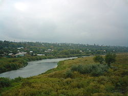 Tuzlov in Novocherkassk . View from the descent of Herzen . Tuzlov in Novocherkassk . View from the descent of Herzen . | |
| Characteristic | |
| Length | 182 km |
| Pool | 4680 km² |
| Water consumption | 2.1 m³ / s (60 km from the mouth) |
| Watercourse | |
| Source | |
| • Location | southern slope of the Donetsk ridge , north of the village of Verkhnetuzlovo |
| • Coordinates | |
| Mouth | Aksay |
| • Location | Novocherkassk city |
| • Coordinates | |
| Location | |
| Water system | Aksay → Don → Sea of Azov |
| Country |
|
| Regions | Lugansk region , Rostov region |
| Areas | Sverdlovsk district , Rodionovo-Nesvetaysky district , Kuibyshevsky district , Myasnikovsky district , Aksaysky district , Novocherkassk |
| HWR code | |

The length of the river is 182 km [2] , the catchment area is 4680 km² [2] .
Geography

It originates on the southern slope of the Donetsk ridge at an altitude of about 190 m [5] under the name Left Tuzlov [2] [3] on the territory of the Sverdlovsk district of the Luhansk region of Ukraine. It flows through the territory of Ukraine for 10 km, including 4 km along the border of Russia with Ukraine, [3] the rest of the flow - in the Rostov region of Russia.
After accepting the tributary of the Middle Tuzlov, the right bank is high and steep, the left one is gentle; narrowed bed. The speeds here are quite high. Near the village of Karpo-Nikolaevka, the river turns east and the valley expands significantly, forming a wide loan. The river bed becomes winding, significantly increases its length, by almost 30-40 km against a straight line, forming a series of loops.
It flows along the flat terrain, the flow velocity does not exceed 1 m / s. The channel is meandering, meander type.
Water Mode
Mixed food (mostly snow). The volume of river runoff is formed due to snow, rain and underground nutrition. High water in March - April. In the upper reaches in summer, it dries up. The average annual flow rate is 60 km from the mouth of 2.1 m³ / s, the maximum is 415 m³ / s, the minimum is 0.19 m³ / s.
History
Tuzlov is described in ESB as follows:
Tuzlov - the river of the Don region, originates in the Taganrog district, along which it flows in the southeast direction, then turns east - along the northern border of Rostov, crosses the Cherkasy district and flows into the Don on the right side near the city of Novocherkassk. Length 104 versts, non-navigable. The Grushevka River (anthracite deposit) is remarkable from its tributaries.
Tributaries
(km from the mouth)
- 2 km: Kadamovka - (l)
- 30 km: Grushevka - (l)
- 44 km: Big Nesvetay - (l)
- 72 km: Sukhoi Nesvetay - (l)
- 101 km: Biryuchya - (l)
- 112 km: Strong - (l)
- 125 km: Salantyr - (l)
- 146 km: Middle Tuzlov - (p)
Flora and Fauna
During research in 2015—2016 38 zooplankton taxa were recorded in the river, of which 28 species and forms of Rotifera (74%), 5 - Copepoda (13%) and 5 - Cladocera (13%) [6] .
According to long-term observations of the Aksay regional fish inspection, producers of fish, shemai, pike perch, bream, carp, pike, and pike are visited annually in the spring for spawning in the Tuzlov river basin through the Aksai channel, and the number of fish entering from year to year varies very much, and the spawning rate depends from the water content of the year. The studies revealed that the juveniles of many fish species in the lower and middle reaches of the river to a large extent use zooplankers for feeding right up to the slope in the river. Don and the Sea of Azov [6] .
Settlements
(from source to mouth)
- Verkhnetuzlovo village
- settlement Alekseevo-Tuzlovka
- Timsk farm
- farm Nagorno-Tuzlovka
- farm Mezentsev
- Filinsky farm
- farm Vlasovo-Burtovka
- farm Denisovo-Alekseevka
- farm Denisovo-Nikolaevka
- Russian-Lutino farm
- Farm Krutoy Yar
- Krinichno-Lugsky farm
- Lysogorka village
- Kryukovo farm
- Karshenno-Annenka village
- Grekovo-Ulyanovka village
- farm New Ukraine
- Farm Postal Yar
- Bolshekrepinskaya settlement
- Chistopolie village
- farm Savchenko
- Sloboda Petrovka
- Karpo-Nikolaevka village
- Stoyanov farm
- General village
- Nesvetai village
- Elite Village
- October village
- Garden village
- Kamenny Brod farm
- hamlet Kamyshevakha
- Grushevskaya village
- Novocherkassk
- Krivyansk village
Notes
- ↑ Surface Water Resources of the USSR: Hydrological Understanding. T. 7. Donskoy district / ed. D. D. Mordukhai-Boltovsky. - L .: Gidrometeoizdat, 1964 .-- 267 p.
- ↑ 1 2 3 4 State Water Register . Tuzlov River (Left Tuzlov) . textual.ru . Ministry of Natural Resources of Russia (March 29, 2009). Date of treatment December 20, 2018. Archived March 29, 2009.
- ↑ 1 2 3 Tuzlov . - An article from the popular science encyclopedia Water of Russia.
- ↑ The etymological dictionary of the Russian language of Max Fasmer - Tuzla
- ↑ Map sheet L-37-8-A - FSUE GOSGISCENTER
- ↑ 1 2 Kovtun I.I. To the study of the zooplankton of the Tuzlov River in the modern period .
Links
Sources
- Tuzlov - an article from the Great Soviet Encyclopedia .
- Tuzlov // Encyclopedic Dictionary of Brockhaus and Efron : in 86 volumes (82 volumes and 4 additional). - SPb. , 1890-1907.
See also
- Rivers of the Rostov region