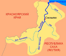
Anabar , in the upper Upper Bolshoy Kuonamka ( Yakut. Anabyr ) is a river in the north-west of Yakutia in Russia . It falls into the Laptev Sea .
| Anabar | |
|---|---|
| Yakut. Anabyr | |
 | |
| Characteristic | |
| Length | 939 km |
| Pool | 100,000 km² |
| Water consumption | 498 m³ / s |
| Watercourse | |
| Source | |
| • Location | Anabar Plateau |
| • Height | above 450 m |
| • Coordinates | |
| Mouth | Laptev sea |
| • Location | Anabar lip |
| • Height | 0 m |
| • Coordinates | |
| Location | |
| Water system | Laptev sea |
| A country |
|
| Region | Yakutia |
| Areas | Oleneksky district , Anabar ulus |
| HWR code | |

Geography
The river is 939 km long (with Big Kuonamka ), the catchment area is 100,000 km² [2] . There are many lakes in the pool.
The source is located in the southern part of the Anabar Plateau (part of the Central Siberian Plateau ), where the river forms a valley with steep and steep banks.
Upon reaching the North Siberian Lowland , the Anabara Valley expands significantly.
In the lower reaches of the river, closer to the left bank, opposite the branch of the large Dumastai-Tёbyulege channel, there are two islands - Sinniges-Ary and Ystakan-Aryta [3] .
At the mouth, the river forms a long shallow estuary - the Anabar Bay , passing further into the Anabar Bay .
Hydrology
Food is mainly snow and rain. The average annual flow rate is 498 m³ / sec. Freezing from late September to early June [4] .
Economic Use
Diamond deposits are located in the Anabara basin [4] . The largest settlement-ports: Saskylakh , Yuryung-Khaya , Ebelakh , Zhilinda .
Gallery
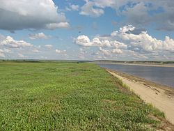
Near the village Saskylah
Doruokha - an abandoned village on the banks of the river
Tributaries
The main tributaries: Mayat , Fishing , Ebelakh - right; Suolema , Harabyl , Connies - left [4] .
Tributaries
(km from the mouth)
- 0.8 km: Suolema
- 11 km: Sergey-Yuryage
- 15 km: Dyryspanai-Sene
- 27 km: Ystakan
- 28 km: untitled
- 36 km: untitled
- 36 km: Dyrang
- 53 km: Kharabyl
- 53 km: Kharabylkan
- 54 km: Poropuon Yuryage
- 67 km: Bulung
- 73 km: Ochuosa-Yuryage
- 80 km: untitled
- 82 km: untitled
- 85 km: Connies
- 89 km: Maria Agatyn Salata
- 90 km: Jieliah Yuryakh
- 92 km: no name
- 93 km: Samti Salata
- 97 km: Sodiyomikha
- 113 km: Half
- 122 km: Average
- 124 km: Baltai-Yuryakh
- 140 km: Chokhoyuk-Yuryakh
- 146 km: Tereng-Yuryakh
- 153 km: Nyucca-Jielah
- 157 km: Jacob
- 184 km: Doruokha
- 186 km: Jama
- 192 km: Oyun-Yuryage
- 200 km: Oyulge
- 206 km: Egdek
- 210 km: Halgannah
- 214 km: Alahchaan
- 219 km: Kardiaanay
- 221 km: Emaehsin-Yurege
- 228 km: Tonguulaah
- 234 km: Halgannah
- 240 km: Tyugeh-Yurekh
- 247 km: Udya
- 256 km: Curüüktüur
- 261 km: Fedor
- 265 km: no name
- 276 km: ruch. Khaybyt
- 290 km: Kychkin
- 293 km: Yamalah
- 301 km: Uchakh-Ytyrbat
- 304 km: Mayat
- 318 km: Hara Mas
- 323 km: Ochuos
- 338 km: Billeheh
- 343 km: Melania
- 357 km: Samaldeen
- 361 km: Ebelah
- 373 km: creek Yargalaah
- 375 km: Newöküleeh
- 377 km: Ognignor Yurege
- 380 km: Malaya Kuonamka
- 384 km: Ochchugui-Tylen
- 404 km: Ulakhan Tyulen
- 412 km: Old
- 415 km: Tylkach
- 427 km: Kuota
- 430 km: Cieres
- 432 km: untitled
- 437 km: Arbaibyt
- 440 km: untitled
- 451 km: Soto
- 457 km: Machala
- 459 km: Haptasynnach
- 460 km: untitled
- 464 km: Talahtaah
- 471 km: Alyn-Mukkun
- 474 km: Yughia Mukkun
- 479 km: no name
- 481 km: Nebaibyt
- 488 km: untitled
- 493 km: Aryy-Mastaah (Billeeh, Kugdalaan-Billeeh)
- 504 km: Bargydamalah
- 504 km: Leo. Bargidamalaah
- 505 km: Right Bargidamalaah
- 515 km: untitled
- 519 km: Achchygy-Khos-Yurekh
- 521 km: Ulohan-Khos-Yurekh
- 537 km: Dukan
- 550 km: Hohoy
- 568 km: Hapchaan
- 583 km: Maatyrcha
- 595 km: untitled
- 609 km: Laahy
- 624 km: Wattah
- 627 km: Dyalinda (Kilegir, Kilegir-Dielinda)
- 632 km: Tangaralaah
- 649 km: untitled
- 662 km: no name
- 663 km: Sulbalah
- 670 km: ruch. Left
- 671 km: Ayahan-Yurege
- 683 km: Saaska-yurege
- 695 km: Khatyryk
- 701 km: Kurung-Yurekh
- 718 km: Sirbeyen
- 721 km: Oyuur-Yurekh
- 734 km: Oyuur-Yurekh
- 735 km: Enbeke
- 746 km: Tyastah
- 747 km: Diegees
- 755 km: ruch. Kuogastaah
- 760 km: ruch. Yuchegei-Yurekh
- 778 km: Daldyn
- 780 km: Balagannah
- 792 km: ruch. Chardaat Yurege
- 796 km: Monholo
- 800 km: ruch. Churbukulah
- 806 km: Etiebin
- 824 km: Alyy-Yurekh
- 841 km: untitled
- 849 km: Küntükeläeh
- 852 km: Nymes
- 871 km: Cyrilles
- 877 km: Balagannah
- 893 km: Knyazeva
- 897 km: Darikhan
- 918 km: Ambardah Salaa
Notes
- ↑ Surface Water Resources of the USSR: Hydrological Understanding. T. 17. Lensko-Indigirsky district. Vol. 6. R. Khatanga, Anabar and Olenek / ed. A. S. Sharoglazova. - L .: Gidrometeoizdat, 1964 .-- 222 p.
- ↑ State Water Register . Anabar (Bol. Kuonapka) . textual.ru . Ministry of Natural Resources of Russia (March 29, 2009). Date of treatment December 20, 2018. Archived March 29, 2009.
- ↑ Map sheet S-49-XXIX, XXX of Uryung-Khaya . Scale: 1: 200 000. Indicate the date of issue / condition of the area .
- ↑ 1 2 3 Anabar // Great Soviet Encyclopedia : [in 30 vol.] / Ch. ed. A.M. Prokhorov . - 3rd ed. - M .: Soviet Encyclopedia, 1969-1978.
Literature
- Glushkov A.V. Rivers of the East of Russia: Guide-book . - Ed. 2nd. - Yakutsk, 2016 .-- S. 7-16. - 502 s. Archived copy of October 16, 2016 on the Wayback Machine (The book contains reference information about 128 rivers of the Anabar, Olenek , Lena , Yana , Indigirka , Kolyma and Okhotsk basins , promising for water trips of various complexity categories)
- Encyclopedic Geographic Dictionary: Geographic Names / Ch. Ed. A. F. Treshnikov ; Ed. col .: E. B. Alaev, P. M. Alampiev, A. G. Voronov and others. - M .: Sov. Encyclopedia, 1983.- S. 26.- 538 p. - 100,000 copies.
Links
- Anabara // Encyclopedic Dictionary of Brockhaus and Efron : in 86 volumes (82 volumes and 4 additional). - SPb. , 1890-1907.