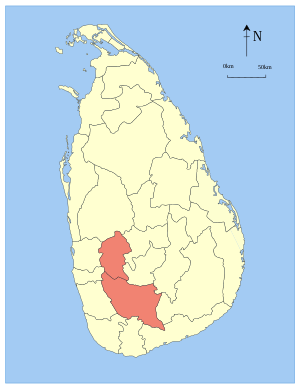
Sabaragamuva ( Sinhala. සබරගමුව පළාත Sabaragamuwa Palata , there. சபரகமுவ மாகாணம் Sabaragamuwa Maakaanam ) - the province of Sri Lanka . Named after Sabars, former locals ethnically related to India . The population is 1 919 478 people (as of 2012).
| provinces | |||
| Sabaragamuva | |||
|---|---|---|---|
| Sinhala සබරගමුව පළාත there. சபரகமுவ மாகாணம் | |||
| |||
| A country | Sri Lanka | ||
| Includes | 2 counties | ||
| Adm. center | Ratnapura | ||
| History and Geography | |||
| Area | 4 968 km² (8th place ) | ||
| Timezone | UTC + 5: 30 | ||
| Population | |||
| Population | 1 919 478 people ( 2012 ) ( 5th place ) | ||
| Density | 386.37 people / km² (4th place) | ||
| Digital identifiers | |||
| ISO 3166-2 Code | LK-9 | ||
| Official site | |||
 | |||
![Flag [d]](http://upload.wikimedia.org/wikipedia/commons/thumb/a/ac/Flag_of_the_Sabaragamuwa_Province_%28Sri_Lanka%29.PNG/160px-Flag_of_the_Sabaragamuwa_Province_%28Sri_Lanka%29.PNG)
The area of the Central Province is 4968 km² [1] . The land area is 4921 km² [1] . The surface of the water surface is 47 km² [1] .
The province is divided into 2 districts:
- Ratnapura Center - Ratnapura
- Kegalle Center - Kegalle
Notes
- ↑ 1 2 3 Area of Sri Lanka by province and district (unavailable link) . Statistics Statistical Abstract 2010 . Department of Census & Statistics, Sri Lanka. Date of treatment January 13, 2013. Archived January 19, 2013.