

Black Way - the historical name of the road connecting the Crimea with the Right Bank of the Dnieper. Used for trade, movement of people and livestock.
There is reason to believe that the road (dry path) existed even in the time of Ancient Russia .
In foreign sources of that period, the path (shlyah) was called - Czarny Szlak [1] or Via Nigra [2] . There is evidence that it was used until the XVIII century [2] , and after the disappearance of the Crimean Khanate , at the end of the XVIII century, the Black Way and its branches, under the name " Chumatsky Way ", were used to deliver salt (and other goods) to the population [2] . Part of the Black Hat , passing through the Wild Field , was one of the few transport arteries in its space.
Content
- 1 Route
- 2 See also
- 3 notes
- 4 Literature
- 5 Links
Route
... Having captured the Middle and Lower Dnieper in 1240 , the Mongols expelled the Rus in the forests, turning the entire land into nomadic lands . Its right-bank part was crossed by a wide Black Way - a road punched and devastated by the Tumen during campaigns in Europe . ...
- Ivan Chernikov “Russian Ukrainians. Conquests of the Great Empire ”, St. Petersburg , 2008.
The path began from the Perekop Isthmus, passed through Zaporozhye and went out to the Black Forest (the upper reaches of Ingulz , Ingul , Tyasmin ). After that, the path turned west and was divided into two parts - northern and southern. The Kuchmansky gut that went south was almost immediately separated from the southern branch, after which it continued towards Shpoli , Talnoy , Uman , Dashev . The northern branch passed near Korsun , Boguslav , Lysyanka , Zhashkov , Tetiev .
Both branches connected in the region of Lipovets (modern Vinnytsia region ), after which the Black Way continued westward towards Khmelnik , Ternopol and Lvov .
A little later, at the beginning of the 18th century, on the map of the Russian Tracts of A. Rusov we find in the Alexandria district only one “Black Hole” , which contacted the Bakaev gent (walking from the tops of the Oka River ) and passing to Ochakov . This road, crossing the river. Tyasmin near Chigirin , captured the northwestern corner of the Alexandria district, walked past the Black Forest and passed to the Yelisavetgrad district through Ingul , most likely, from the Ingul Kamenka .
- “Materials for assessing the lands of the Kherson province.”
See also
- Voloshsky or Moldavian noble
Notes
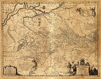
- ↑ Guillaume Levasser de Beauplan , French engineer and cartographer, map (plan) “General plan of the Wild Fields , in other words, Ukraine ”, (“Delineatio Generalis Camporum Desertorum vulgo Ukraina”), 1648.
- ↑ 1 2 3 Black Way - a historic road.
Literature
- P. Kulish, “The History of the Reunification of Russia.”, St. Petersburg. , 1874, T. 1.
- A. Storozhenko, “Stefan Batory and the Dnieper Cossacks”, K. , 1904
- V. Kordt, “Materials on the History of Russian Cartography.” Vol. II., K., 1910, tab. VII.
- "Great Soviet Encyclopedia"
- Michalon Litvin, “On the customs of the Tatars, Lithuanians and Muscovites.” - M. , 1994
Links
- Guillaume Levasser de Boplan , French engineer and cartographer, map (plan) “General plan of the Wild Fields, in other words, Ukraine”, (“Delineatio Generalis Camporum Desertorum vulgo Ukraina”), 1648.
- Representations of the Black Way in the 19th century.
- Website
- “Geographical Dictionary of the Kingdom of Poland and Other Slavic Regions.”, Volume I, p. 770 (“Słownik geograficzny Królestwa Polskiego i innych krajów słowiańskich”, Tom I).
- Black hat is a historic road.