Belaya Kolp is a village in the urban district of Shakhovskaya in the Moscow Region of Russia .
| Village | |
| White Kolp | |
|---|---|
 | |
| A country | |
| Subject of the federation | Moscow region |
| City district | Shakhovskaya |
| History and Geography | |
| First mention | 1497 year |
| Timezone | UTC + 3 |
| Population | |
| Population | ↗ 878 [1] people ( 2010 ) |
| Digital identifiers | |
| Postcode | 143715 |
| OKATO Code | |
| OKTMO Code | |
The population is 878 [1] people. (2010).
Geography
It is located in the west of the Moscow region, in the northeastern part of the Shakhovsky district, on the Muravka river of the Shoshi basin, 13 km from the urban-type settlement Shakhovskaya , which is connected with direct bus service [2] . There is 21 street in the village [3] . The nearest settlements are the villages of Berkunovo , Zatesovo and Plenitsino .
Population
| Population | |||||
|---|---|---|---|---|---|
| 1852 [4] | 1859 [5] | 1926 [6] | 2002 [7] | 2006 [8] | 2010 [1] |
| 285 | ↗ 406 | ↘ 243 | ↗ 824 | ↗ 829 | ↗ 878 |
History
For the first time, the village of Kolp (Kolp is a white heron) is mentioned in the exchange certificate of Moscow Prince Ivan III in 1497. Then the Tver villages Kolp and Buigorod were given in exchange to the Volotsk princes Ivan and Fedor Borisovich . At the beginning of the XVI century, there was a tower palace of Vasily III . In 1634, the village of Andreevskoye-Kolp was sold to the boyar Vasily Ivanovich Streshnev .
In 1658, the village passed into the possession of the stolnik Stepan Nikitich Shakhovsky and for more than 250 years has been the family estate of the Shakhovskys . For example, in 1769, the village of Kolpsky camp of the Volokolamsk district of the Moscow province was owned by the second-major life guard , Prince Alexander Alekseevich Shakhovskaya. There were 59 yards and 214 souls in the village [9] .
In the XVIII century a manor was built, rebuilt at the beginning of the XIX century. The estate included the main manor house (burned down in 1919), the manager’s house, a stable (leftover remains), a horse carriage (leftover remains), a kennel (lost in the 1980s), St. Andrew’s church (1807), a brick wall (not preserved) , terrace park, lime park, a dam on the Kolpianka River.
Until the 17th century, there were two wooden churches in the village - in honor of the martyr Andrei Stratilat and in honor of the wonderworkers Cosmas and Damian - both burned during the Lithuanian invasion in 1626. In 1686-1691, a new wooden church of Andrei Stratilat was built. The stone church (St. Andrew's Church) in honor of the Resurrection of Christ with chapels in honor of Andrei Stratilat and Prince of Murom of Constantine and his children Michael and Theodore was built in 1807 according to the personal project of Prince Mikhail Alexandrovich Shakhovsky in the style of classicism . In 1818, a three-tier bell tower was built [10] . After the death of Prince M.A. Shakhovsky in 1817, his son Valentin Mikhailovich Shakhovsky entered into the possession of the village of Belaya Kolp.
In the middle of the XIX century, the village of Belaya Kolp belonged to the 1st camp of the Volokolamsk district and belonged to Valentin Mikhailovich Shakhovsky. In the village there were 34 households, peasants 135 male souls and 150 female souls [4] .
In the “List of Populated Places” of 1862 - the owner's village of the 1st camp of the Volokolamsk district of the Moscow province, on the left side of the Moscow highway, going from the border of the Zubtsov district to the city of Volokolamsk , 18 miles from the county town, with a pond and wells, with 53 yards , 406 residents (198 men, 208 women) and the church [5] .
In 1886 - 41 yards, 331 inhabitants, a church, a shop and a cheese factory [11] .
According to the data for 1890, the village was part of the Kulpino volost , the number of male souls was 142 people, there was an apartment for a police officer [12] .
The last owner of the village was the son of Privy Councilor Alexander Valentinovich Shakhovsky , Valentin Alexandrovich Shakhovsky (1885-1927). In 1913, in the village there were 55 yards, a zemstvo school, 2 tea houses, 2 vegetable and state wine shops, a brick factory, as well as his estate with a cell of the zemsky chief of the 3rd section [13] .
According to the materials of the 1926 All-Union Population Census - two villages of the Belokolpsky village council of the Ramensky volost . In Belaya Kolpi (center of the village council), there were 43 households (35 peasant), 243 residents (126 men, 117 women), there were a school and a district library. In Krasnaya Kolpi (southern part) there were 30 households (29 peasant) and 177 inhabitants (73 men, 104 women) [6] .
1994-2006 - the center of the Belokolpsky rural district of the Shakhovsky district [14] .
2006—2015 - the village of the rural settlement of Ramenskoye, Shakhovsky district [15] [16] .
2015 - n. at. - The village of the urban district Shakhovskaya of the Moscow region [17] [18] .
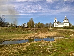
Attractions
- Memorial to the Fallen Soldiers
- Church of Andrei Stratilat
Famous Natives
- Volkov Sergey Petrovich - Hero of the Soviet Union.
Notes
- ↑ 1 2 3 The size of the rural population and its distribution in the Moscow Region (results of the 2010 All-Russian Population Census). Volume III (DOC + RAR). M .: Territorial authority of the Federal State Statistics Service for the Moscow Region (2013). Date of treatment October 20, 2013. Archived October 20, 2013.
- ↑ Schedule of route No. 41 Shakhovskaya - Berkunovo . State Unitary Enterprise of Passenger Road Transport Mostransavto. Date accessed May 5, 2015. (unavailable link)
- ↑ Classifier of addresses of the Russian Federation . The state register of addresses of the Federal Tax Service of Russia. Date of treatment May 5, 2015.
- ↑ 1 2 Nistrem K. Index of villages and residents of counties of the Moscow province. - M. , 1852. - 954 p.
- ↑ 1 2 Lists of populated places of the Russian Empire. Moscow province. According to the information of 1859 / Art. ed. E. Ogorodnikov. - Central Statistical Committee of the Ministry of the Interior. - SPb. , 1862. - T. XXIV.
- ↑ 1 2 Handbook on populated areas of the Moscow province . - Moscow Statistics Division. - M. , 1929. - 2000 copies.
- ↑ 2002 All-Russian Census Data: Table No. 02c. Population and prevailing nationality for each rural locality. M .: Federal State Statistics Service, 2004
- ↑ Alphabetical list of settlements of municipal districts of the Moscow Region as of January 1, 2006 (RTF + ZIP). The development of local government in the Moscow region. Date of treatment February 4, 2013. Archived January 11, 2012.
- ↑ Kusov V.S., Lands of the Moscow province in the 18th century. - M .: Muscovy, 2004. - T. I. - S. 121–122. - 315 p. - ISBN 5-7151-0081-X .
- ↑ The temple is interesting in that the altar is not located in the eastern part, as is customary in church tradition, but in the northern part. The church was closed in the late 1930s. Until 1997, the premises were used by the collective farm as a granary. In 1997, the church was returned to believers. Recovery in progress. Since 2001, a Sunday school has been operating.
- ↑ Volosts and the most important villages of European Russia. Issue II: Provinces of the Moscow Industrial Region. Moscow, Tver, Yaroslavl, Kostroma, Nizhny Novgorod, Vladimir . - Central Statistical Committee. - SPb. , 1886. - S. 28. - 317 p.
- ↑ Shramchenko A.P. Reference book of the Moscow province (description of counties). - M. , 1890. - S. 160. - 420 p.
- ↑ Populated areas of the Moscow province / B.N. Penkin. - Moscow Metropolitan and Provincial Statistical Committee. - M. , 1913. - S. 157. - 454 p.
- ↑ Handbook of the administrative-territorial structure of the Moscow region. - M. , 1999 .-- S. 32. - 335 p. - 1,500 copies
- ↑ Law of the Moscow Region of February 28, 2005 No. 62/2005-OZ “On the Status and Borders of the Shakhovsky Municipal District and the municipalities newly formed in its composition” (adopted by resolution of the Moscow Regional Duma of February 16, 2005 No. 6/129-P) . Date of treatment January 21, 2014.
- ↑ Resolution of the Governor of the Moscow Region dated November 29, 2006 No. 156-PG “On the exclusion of rural districts from the accounting data of the administrative-territorial and territorial units of the Moscow Region” . Date of treatment April 17, 2014.
- ↑ Law of the Moscow Region of October 26, 2015 No. 178/2015-OZ “On the organization of local self-government in the territory of the Shakhovsky municipal district” (adopted by resolution of the Moscow regional Duma of October 15, 2015 No. 23/142-P) . Date of treatment January 3, 2016.
- ↑ Law of the Moscow Region dated November 25, 2015 No. 207/2015-OZ “On the classification of the city of Yegoryevsk, the Yegoryevsky district of the Moscow region, the city of Kashira, the Kashirsky district of the Moscow region, and the city of Mytishchi, the Mytishchi district of the Moscow region, as the city of regional subordination of the Moscow region, the classification of the working village Serebryanye Prudy Serebryano-Prudsky district of the Moscow region and the working village of Shakhovskaya, Shakhovsky district of the Moscow region to the category of urban-type towns of regional subordination to the Moscow region, its abolition Ryevsky, Kashirsky, Mytishchinsky, Serebryano-Prudsky and Shakhovsky districts of the Moscow Region and amendments to the Law of the Moscow Region “On the administrative-territorial structure of the Moscow Region” ”(adopted by resolution of the Moscow Regional Duma of November 19, 2015 No. 6/146-P) . Date of treatment January 3, 2016.