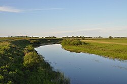
Chulym - a river in the Novosibirsk region , belongs to the basin of internal flow, originates in the Vasyugan marshes and flows into the Small Chany Lake, passing through large flowing lakes - Uryum and Sargul . In waterlogged lowlands there are many waterfowl.
| Chulym | |
|---|---|
 | |
| Characteristic | |
| Length | 392 km |
| Pool | 17 900 km² |
| Watercourse | |
| Source | Vasyugan swamps |
| • Height | 154 m |
| • Coordinates | |
| Mouth | Minor vats |
| • Height | 106 m |
| • Coordinates | |
| River slope | 0.12 m / km |
| Location | |
| Water system | Vats |
| A country |
|
| Region | Novosibirsk region |
| Areas | Kochenevsky district , Chulymsky district , Kargatsky district , Dovolensky district , Zdvinsky district |
| HWR Code | |

Content
Geography
On Chulym, there is the city of Chulym , named after the river (there the river also crosses the Trans-Siberian Railway (section Omsk - Novosibirsk ) and the M51 highway), the village of Starogornostalevo .
The inflow to the right is the Kargat River . It falls into Chulym west of the village of Mishino in the Zdvinsky district of the Novosibirsk region.
Hydrological regime
The river flow is calm, the slopes are small. The main source of food for the river is winter rainfall (93%), the share of rainfall is 2%, and groundwater is 5%.
It is usually covered with ice in November, and opened in April.
Data from 1947 to 1991, collected in the area of the village of Yarki [2] , show the main hydrological characteristics:
- The maximum water discharge occurs in April-May and corresponds to the period of melting of the snow cover.
- The minimum water flow occurs in November-March and corresponds to the period when the river is covered with ice.
- The volume of annual water consumption varies widely (the minimum average monthly water consumption in cubic meters per second, averaged over the year - 0.62 (1991), max - 19.34 (1986) - the difference is more than 30 times)
Observation data at the Yarki hydrometric station from 1947 to 1991
Mineralization
The water in the river is fresh. However, the degree of its mineralization depends on the season (in the spring - from 200 to 450, and in the summer - from 450 to 2055 mg / l).
Also, mineralization varies from source to mouth. In the summer of 2005, the following results were obtained [3] :
- Upper course (channel width - about 5 m) - 595 mg / l
- Average course (channel width - about 8-10 m) - 720 mg / l
- Lower course (channel width - about 15 m) - 1137 mg / l
- Wellhead flow (channel width - about 20 m) - 820 mg / l
Links
- Chulym (river in the Novosibirsk region) - an article from the Great Soviet Encyclopedia .
Notes
- ↑ Surface water resources of the USSR: Hydrological knowledge. T. 15. Altai and Western Siberia. Issue 2. Average Ob / ed. V.V. Seeberg. - L .: Gidrometeoizdat, 1967. - 351 p.
- ↑ The results of measurements of the water discharge of the Chulym river at the Yarki hydrometric station from 1947 to 1991
- ↑ VEGETATION OF THE CHULYI RIVERS AND KARGAT (WESTERN SIBERIA) Kipriyanova L.M., Kleschev M.A.