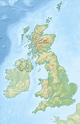
Sanday ( English Sanday ) - an island in the archipelago of the Orkney Islands , at the northern tip of Scotland .
| Sunday | |
|---|---|
| English Sanday | |
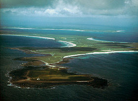 Start Point , the far eastern cape of the island. | |
| Specifications | |
| Square | 50.43 km² |
| Highest point | 65 m |
| Population | 478 people (2001) |
| Population density | 9.48 people / km² |
| Location | |
| Archipelago | Orkney Islands |
| Water area | North Sea |
| A country |
|
| Region | Scotland |
| Area | Orkney |

Etymology
The name of the island comes possibly from the Scandinavian - Sandøy , which means a sandy island. A similar name has the island of Sandoy in the archipelago of the Faroe Islands and the island of Sanday in the archipelago of the Inner Hebrides.
Geography

Located in the northeastern part of the archipelago, the nearest major islands are Stronsay in the south, Ideas in the southwest and North Ronaldsay in the northeast.
It is washed from the south by the Sunday Sound Strait, from the northwest by the North Sound Strait, from the north by the North Ronaldsay Firth Strait.
The area of the island is 50.4 square kilometers [1] . The relief is mostly flat, the soil is fertile and used in agriculture. Lots of sandy beaches.
The island has an East Sandy Coast wildlife sanctuary with an area of 15.1 square kilometers. Under guard [2] :
- Sandpiper (Calidris maritima) - 840 individuals, 1.7% of the population of the East Atlantic.
- Kamensharka (Arenaria interpres) - 1,400 individuals, 2.0% of the population of the biogeographic region of the Palearctic.
Population
The population of the island is 494 people [3] .
Settlements:
- Brothown
- Kettloft
- Northwall
- Skar Manor
Economics
In the center is Sunday Airport , Loganair flights [4] :
- Kirkwall , 11 flights per week, summer 2012.
- Stronsay , 6 flights per week, summer 2012.
Orkney Ferries Ferries , daily to Kirkwall , weekly to Idea Island. Ferries depart from the pier in the southwest of the island [5] .
The B9068 motorway crosses the central part of the island and leads from the village of Kettleft on the southeastern coast to Skar Manor on the northwest coast. B9069 connects the center of the island and the village of Northwall in the northeast. The B9070 connects the ferry crossing in the southwest of the island and the center of the island.
The Start Point Lighthouse is located on the far eastern cape of the island and is run by the Northern Lighthouse Board .
Education
The island has a Sanday Community School [6] . Liam MacArthur , a member of the Scottish Parliament from the single-member Orkney Islands district, studied at the school [7] .
Attractions
- Quinness Cairn - a funerary structure, a cairn of the Neolithic era, built about 2900 BC. e [8] .
- Skar-Bot-Beriel - excavations of a funerary boat , end of the 9th century [9] .
- Homesteads Lopness House (XVII century) [10] [11] , Fitness House (XVII — XIX century) [12] , Worsetter Farm (XVIII century) [13] [14] , Kuivals-Farmhouse (XVIII century) [ 15] , Seville Farmhouse (late 18th century) [16] , Scar House (late 18th – early 19th century, water and windmills) [17] [18] [19] , Geramont Lodge (1835) [20 ] , Bolokoy-Farm (mid-19th century) [21] , Stov-Farmhouse (1857) [22] , Backscale Maynes (1863) [23] , Merigart-Mans (late 19th century) [24] are included in the list monuments of architecture of category "B".
- The Start Point lighthouse on the extreme eastern cape of the island was built according to various sources in 1806, 1870 or 1880. In 1971 he was included in the list of architectural monuments of category “B” [25] [26] [27] .
- Ketltoft Pier - pier in the village of Kettletoft built in 1883. In 1999 it was included in the list of architectural monuments of category “B” [28] .
- At the beginning of the XXI century, the island was the shortest time the northernmost railway in the UK.
Filmography
The island is dedicated to one of the series of the television series about archeology Time Team [29] .
See also
- List of islands in Scotland
Notes
- ↑ Third largest area among the Orkney Islands
- ↑ East Sunday Beach Reserve
- ↑ Fourth most populated among the Orkney Islands
- ↑ Schedule 2012 summer (inaccessible link) . Date of treatment February 1, 2014. Archived on April 7, 2013.
- ↑ Orkney Ferries Ferries
- ↑ Sanday Community School (inaccessible link) . Date of treatment February 1, 2014. Archived February 19, 2014.
- ↑ Liam MacArthur (inaccessible link) . Archived July 5, 2007.
- ↑ Queenness Cairn at canmore.rcahms.gov.uk
- ↑ Scar-Bot-Berial
- ↑ Lopness House
- ↑ Lopness House dovecote
- ↑ Fitness House
- ↑ Worsetter Farm
- ↑ Worsetter Farm Cottages
- ↑ Quivals Farmhouse
- ↑ Saville Farmhouse
- ↑ Skar Manor
- ↑ Skar watermill
- ↑ Skar windmill
- ↑ Geramont Lodge
- ↑ Bolokoy-Farm
- ↑ Stov Farmhouse
- ↑ Backscale Manes
- ↑ Marygart Mans
- ↑ Lighthouse Start Point Northern Lighthouse Board
- ↑ Start Point Lighthouse canmore.rcahms.gov.uk
- ↑ Start Point Lighthouse historic-scotland.gov.uk
- ↑ Kettleft-Pier
- ↑ Time Team season 5 episode 3