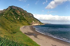
Kuril Islands - a chain of islands between the Kamchatka Peninsula and Hokkaido Island, a slightly convex arc separating the Sea of Okhotsk from the Pacific Ocean . The length is about 1200 km. The total area is 10.5 thousand km² [2] [3] [4] . To the south of them lies the state border of Russia with Japan. The islands form two parallel ridges: the Greater Kuril and Malaya Kuril . Include 56 islands. They have important military-strategic and economic significance [5] .
| Kurile Islands | |
|---|---|
 | |
| Specifications | |
| Number of islands | 56 |
| Largest island | Iturup |
| total area | 10 500 km² |
| Highest point | 2339 m |
| Population | 20 787 people (2019) |
| Population density | 1.98 people / km² |
| Location | |
| Washer water areas | Sea of Okhotsk , Pacific Ocean |
| A country |
|
| The subject of the Russian Federation | Sakhalin Oblast |

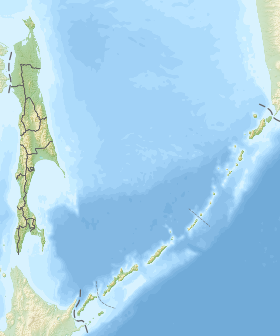
The Kuril Islands are part of the Sakhalin Oblast of Russia . The ownership of the southern islands of the archipelago — Iturup , Kunashir , Shikotan and the Habomai group — is disputed by Japan , which includes them in Hokkaido Prefecture [6] [7] .
Geography
In the thematic literature, the Kuril archipelago is divided into two ridges: the Bolshaya and Malaya . Large, in turn, is traditionally divided into the Northern , Middle and Southern Kuril Islands , which have features in climate, geology, flora and fauna [8] . Despite the fact that, for example, the southern islands are located at the latitude of Anapa , and the island of Shikotan is located at the latitude of the city of Sochi , legally the Kuril Islands belong to the Far North .
Climate
The climate on the islands is low contrast oceanic: on the northern islands it has arctic features, on the southern islands it is close to temperate. Kunashir is considered the warmest, the mildest climate is on the island of Shikotan .
The climate on the islands is marine , with warm winters and mild summers, high humidity does not have a negative effect due to the mild temperature conditions. In winter, temperature differences between the northern and southern islands do not exceed 2 ° C, in August they reach 6 ° C: from +10 ° C in the north to +16 ° C in the south [9] .
The mainland monsoon climate is undergoing significant changes here due to the influence of the Pacific Ocean; frosts are significantly weakening, the average temperature of the coldest month (February) is −5 ° C. The average temperature of the warmest month (August) in Kunashir reaches + 18 ° C, and the average annual temperature exceeds + 6 ° C, on the northern islands, the average temperature in August is at + 10 ° C. [ten]
Shikotan Island Climate
| Climate Malokurilskoye | |||||||||||||
|---|---|---|---|---|---|---|---|---|---|---|---|---|---|
| Indicator | Jan | Feb | March | Apr | May | June | July | Aug | Sep | Oct | Nov | Dec | Year |
| Absolute maximum, ° C | 7.0 | 8.9 | 9.3 | 18.7 | 24.0 | 25.0 | 32.8 | 29.0 | 26.0 | 23.1 | 17.0 | 12.0 | 32.8 |
| Average maximum, ° C | −2.6 | −3.1 | −1 | 5.7 | 9.7 | 12.5 | 16.1 | 18.5 | 16.9 | 12.6 | 7.1 | 1,2 | 7.8 |
| Average temperature, ° C | −4.6 | −5.2 | −3.3 | 2.6 | 6.1 | 9.1 | 12.9 | 15.6 | 13.8 | 9.7 | 4.4 | −1 | 5.1 |
| Average minimum ° C | −6.4 | −7 | −5.2 | 0.4 | 3.8 | 7.0 | 10.9 | 13.7 | 11.8 | 7.5 | 2,4 | −3 | 3.0 |
| Absolute minimum, ° C | −19 | −23.9 | −17.2 | −11 | −3.1 | 1,0 | 2,8 | 6.2 | 2,8 | −5 | −7 | −13.2 | −23.9 |
| Precipitation rate, mm | 78.9 | 80.1 | 83,2 | 60.8 | 66,2 | 72.7 | 69.9 | 75.1 | 85.8 | 77.4 | 62.8 | 81.3 | 894.2 |
| Source: Climatebase.ru | |||||||||||||
Simushir Island Climate
| Climate of Simushira | |||||||||||||
|---|---|---|---|---|---|---|---|---|---|---|---|---|---|
| Indicator | Jan | Feb | March | Apr | May | June | July | Aug | Sep | Oct | Nov | Dec | Year |
| Absolute maximum, ° C | 6.1 | 5,6 | 10.0 | 17.8 | 21.7 | 23.9 | 27.8 | 28.9 | 26.7 | 21.1 | 17.8 | 11.1 | 28.9 |
| Average maximum, ° C | −2.8 | −3.3 | −1.7 | 2.2 | 5,6 | 7.8 | 11.1 | 13.9 | 12.8 | 8.9 | 3.9 | 0,0 | 5,0 |
| Average temperature, ° C | −3.9 | −4.4 | −2.8 | 0.6 | 3.3 | 5,6 | 8.9 | 11.1 | 10.6 | 7.2 | 2.2 | −1.1 | 3.3 |
| Average minimum ° C | −5.6 | −6.1 | −4.4 | −1.1 | 1,1 | 3.3 | 6.1 | 8.3 | 7.8 | 4.4 | 0,0 | −2.8 | 1,1 |
| Absolute minimum, ° C | −16.1 | −15 | −12.2 | −11.7 | −2.8 | −3.9 | 0,0 | 0,0 | 0,0 | −2.8 | −6.7 | −11.1 | −16 |
| Precipitation rate, mm | 107 | 76 | 94 | 124 | 135 | 89 | 104 | 150 | 198 | 198 | 157 | 137 | 1570 |
| Source: weatherbase | |||||||||||||
List of Islands
List of islands with an area of more than 1 km² from north to south.
| Title | Square, km² | Maximum height, m | Latitude | Longitude | Average annual air temperature | Sum of active temperatures |
|---|---|---|---|---|---|---|
| Big Kuril ridge | ||||||
| Northern group | ||||||
| Atlasova | 150 | 2339 | 50 ° 52 ' | 155 ° 34 ' | - | - |
| Shumshu | 388 | 189 | 50 ° 45 ' | 156 ° 21 ' | - | - |
| Paramushir | 2053 | 1816 | 50 ° 23 ' | 155 ° 41 ' | 1,5 | - |
| Antsiferova | 7 | 747 | 50 ° 12 ' | 154 ° 59 ' | - | - |
| Makanrushi | 49 | 1169 | 49 ° 46 ' | 154 ° 26 ' | - | - |
| Onekotan | 425 | 1324 | 49 ° 27 ' | 154 ° 46 ' | - | - |
| Harimkotan | 68 | 1157 | 49 ° 07 ' | 154 ° 32 ' | - | - |
| Chirinkotan | 6 | 724 | 48 ° 59 ' | 153 ° 29 ' | - | - |
| Ekarma | thirty | 1170 | 48 ° 57 ' | 153 ° 57 ' | - | - |
| Shiashkotan | 122 | 934 | 48 ° 49 ' | 154 ° 06 ' | - | - |
| Middle group | ||||||
| Raikoke | 4.6 | 551 | 48 ° 17 ' | 153 ° 15 ' | - | - |
| Matua | 52 | 1446 | 48 ° 05 ' | 153 ° 13 ' | - | 406 [11] |
| Rashua | 67 | 948 | 47 ° 45 ' | 153 ° 01 ' | - | - |
| Ushishir Island | five | 388 | - | - | - | - |
| Ryponkicha | 1.3 | 121 | 47 ° 32 ' | 152 ° 50 ' | - | - |
| Yankich | 3,7 | 388 | 47 ° 31 ' | 152 ° 49 ' | - | - |
| Ketoy | 73 | 1166 | 47 ° 20 ' | 152 ° 31 ' | - | - |
| Simushir | 353 | 1539 | 46 ° 58 ' | 152 ° 00 ' | - | 518 [12] |
| Broughton | 7 | 800 | 46 ° 43 ' | 150 ° 44 ' | - | - |
| Black Brothers | 37 | 749 | - | - | - | - |
| Chirpoy | 21 | 691 | 46 ° 30 ' | 150 ° 55 ' | - | - |
| Brother Chirpoev | sixteen | 749 | 46 ° 28 ' | 150 ° 50 ' | - | - |
| South group | ||||||
| Urup | 1450 | 1426 | 45 ° 54 ' | 149 ° 59 ' | 2.2 | 700-540 [13] |
| Iturup | 3318.8 | 1634 | 45 ° 00 ' | 147 ° 53 ' | 4.3 | 1,350 |
| Kunashir | 1495.24 | 1819 | 44 ° 05 ' | 145 ° 59 ' | 4.7 | 1,700 |
| Small Kuril ridge | ||||||
| Shikotan | 264.13 | 412 | 43 ° 48 ' | 146 ° 45 ' | 5,0 | 1650 |
| Polonsky | 11.57 | sixteen | 43 ° 38 ' | 146 ° 19 ' | - | - |
| Shards | 0.2 | 38 | 43 ° 35 ' | 146 ° 25 ' | - | - |
| Green | 58.72 | 24 | 43 ° 30 ' | 146 ° 08 ' | - | - |
| Tanfilieva | 12.92 | 15 | 43 ° 26 ' | 145 ° 55 ' | - | - |
| Yuri | 10.32 | 44 | 43 ° 25 ' | 146 ° 04 ' | - | - |
| Dyomin Islands | 0.7 | 34 | 43 ° 25 ' | 146 ° 10 ' | - | - |
| Anuchina | 2,35 | 33 | 43 ° 22 ' | 146 ° 00 ' | - | - |
Geological structure
The Kuril Islands are a typical ensimatic island arc on the edge of the Okhotsk plate . It is located above the subduction zone in which the Pacific plate is absorbed. Most of the islands are mountainous. The highest altitude is 2339 m - Atlasova Island , Alaid Volcano. The Kuril Islands are located in the Pacific volcanic ring of fire in a zone of high seismic activity : of 68 volcanoes, 36 are active, there are hot mineral springs. About 12% of the Kuril volcanic craters have lakes, which roughly corresponds to the global indicator [14] . Large tsunamis are frequent. The most famous tsunamis on November 5, 1952 on Paramushir and the Shikotan tsunami on October 5, 1994 . The last of the major tsunamis occurred on November 15, 2006 in Simushira .
Natural resources
On the islands and in the coastal zone, industrial reserves of non-ferrous metal ores, mercury, natural gas, and oil have been explored. On the island of Iturup , in the area of the Kudryavy volcano, there is the richest mineral deposit of rhenium known in the world [15] [16] . It is thrown out of a volcano with fumarole gases along with dozens of other non-ferrous rare and noble metals [17] Here, at the beginning of the 20th century, the Japanese mined native sulfur. The total gold resources in the Kuril Islands are estimated at 1867 tons, silver - 9284 tons, titanium - 39.7 million tons, iron - 273 million tons [18] . Currently, there are not many mining developments.
Of all the Kuril Straits, only the Freeza Strait and Catherine Strait are non-freezing navigable.
Flora and fauna
Flora
Due to the large extent of the islands from north to south, the flora of the Kuril Islands is extremely different. On the northern islands ( Paramushir , Shumshu and others), due to the harsh climate, woody vegetation is rather scarce and is represented mainly by shrubby forms (elfin): alder (alder), birch , willow , mountain ash , cedar elfin (cedrach). On the southern islands ( Iturup , Kunashir ) coniferous forests grow from Sakhalin fir , Ayan spruce and Kuril larch with a large participation of broad - leaved species: curly oak , maples , elms , seven-bladed kalopanaks with a large number of woody vines: petrel hydrangea , actinid grapes , poisonous eastern toxicodendron , etc. In the south of Kunashir, there is the only wild-growing species of magnolia in Russia - obovate magnolia . One of the main landscape plants of the Kuril Islands, starting from the middle islands ( Ketoi and to the south) is the Kuril bamboo , which forms impenetrable thickets on the mountain slopes and forest edges. Due to the humid climate, tall grass is common on all islands. Various berries are widely represented: crowberry , lingonberry , blueberry , honeysuckle and others.
Endemic plants, there are more than 40 species . For example, astragalus of Kavakam , wormwood , edelweiss, Kuril , found on the island of Iturup; Ito wilderness and the Kuril saussure growing on the island of Urup.
The following plants are protected on Iturup Island: Asian endangered bush, flowering plants, mainland aralia, heart-shaped aralia , seven-bladed kalopanax , Japanese kandyk , viburnum Wright , Glen's cardiocrinum , backyose peony , Rhododendron Fori , Holly Sugeroki , pearl moss wolfberry low , peony mountain , lichens glossodium Japanese and stereocaulon nude , gymnosperms juniper Sargenta and yew spiky , bryophytic bryoxiphyme savye and atractylocarpus alpine , growing near the volcano Baransky . On the island of Urup, the guelder-rose of Wright is protected, the aralia is cordate and dull plagiotium .
Fauna
A brown bear lives on Kunashir , Iturup and Paramushir , and the bear was also found on Shumsha , but during the long-term stay on the island of a military base, due to its relatively small size, the bears on Shumsha were mainly killed. Shumshu is a connecting island between Paramushir and Kamchatka , and individual bears are now found there. The islands are inhabited by foxes , small rodents . A large number of birds: plovers , gulls , ducks , cormorants , petrels , albatrosses , passerines , owls , falcons and others. Many bird colonies . Along the islands lies the most important way of bird migration from north to south and back [19] .
The coastal underwater world, unlike the islands, is not only numerous, but also very diverse. Seals , sea otters , killer whales , and sea lions inhabit the coastal waters. Of great commercial importance are: fish [20] , crabs , mollusks , squids , crustaceans , sea cucumbers , sea cucumbers , sea urchins , sea kale . The seas washing the coast of the Kuril Islands are one of the most productive areas of the oceans.
Endemic animals ( mollusks ) are also present on Iturup Island: iturup lacustrine , Iturup sharovka (Lake Raidovo), Kuril pearl mussel , on the Dobroe lake there are synanodontic kunashiriya and Iturup shutter .
On February 10, 1984, the Kurilsky State Nature Reserve was created [21] . On its territory there are 84 species included in the Red Book of Russia [22] [23] .
Island History
XVII century
Before the arrival of Russian and Japanese, the islands were inhabited by Ainu . In their language, “kuru” meant “man,” whence came their second name “smokers,” and then the name of the archipelago. [24]
The Russian exploration of the Kuril Islands began with a detachment of Cossacks led by ataman Fedot Popov. A detachment of 17 people on a light vessel passed through the strait between Kamchatka and Shumshu Island.
The first information about the islands was obtained by the Japanese during an expedition to Hokkaido and Sakhalin in 1635. In 1644, following the expeditions of 1635–1637, the first Japanese map of Sakhalin and the Kuril Islands was compiled in Hokkaido [25] .
In 1643, the islands were examined by the Dutch, led by Martin de Vries . This expedition compiled more detailed maps and described the land. On June 20, 1643, the expedition discovered a strait between the islands of Iturup and Urup (currently the Strait of Frieza ) [26] . De Vries mistakenly considered Iturup Island to be the northeastern tip of Hokkaido, and Urup as part of the Americas. On the same day, June 20, Dutch sailors first landed on Urup [25] . On June 23, 1643, de Vries erected a wooden cross on the flat top of the high mountain of Urup Island and declared this land the property of the Dutch East India Company [25] .
In Russia, the first mention of the Kuril Islands dates back to 1646, when Cossack Nekhoroshko Ivanovich Kolobov, a member of the expedition of Ivan Moskvitin to the Sea of Okhotsk (Lam), spoke about the bearded Ainu inhabiting the islands [27] .
New information about the Kuril Islands appeared after the campaign of Vladimir Atlasov to Kamchatka in 1697, during which the Russians first saw the northern Kuril Islands from the southwestern coast of Kamchatka:
“And against the first Kuril river, I saw the sea as if there were islands, and foreigners say that there are islands, and on those islands there are stone cities and people live, and which foreigners don’t know about that. And from those de islands to the Kuril foreigners came Tsenin's dishes and dub striped and colorful dresses, Chinese women and Lenzian azameas. And those Kuril foreigners said that they give them dishes and clothes for nothing, but don’t buy anything. And on what from those islands people come to the Kuril Islands, the foreigners cannot say that. ” [25]
18th century
For the first time, Russians entered the Kuril land in 1711 . This happened due to the revolt of the Kamchatka Cossacks, as a result of which three Kamchatka clerks were killed, including V.V. Atlasov . To receive the forgiveness of the king, the Cossacks decided to conduct an expedition to the Kuril Islands. In August 1711, a detachment of Kamchatka Cossacks led by Danila Antsiferov and Ivan Kozyrevsky landed on the northernmost island of Shumshu , defeating a detachment of local Ainu, and then on the second island of the ridge - Paramushir , where the locals, who outnumbered the Cossacks by number, refused citizenship and did not began to pay yasak. In the summer of 1713, a detachment of fifty-five Cossacks and industrialists again went to Shumsha and Paramushir, this time the Ainu recognized the power of Russia, two of them were taken hostages. During the expedition, an Iturup Ain named Shinatai was taken prisoner , from him was I.P. Kozyrevsky and received detailed information about most of the Kuril Islands and the island of Hokkaido. [28] In 1719, Peter I sent an expedition to Kamchatka led by Ivan Evreinov and Fedor Luzhin , which reached the island of Simushira in the south. The open islands were included in Russia (General map of the Irkutsk province in 1776).
Great success was achieved by the Siberian nobleman I. Antipin with the Irkutsk posad D. Shabalin [29] . During several expeditions, they managed to win the favor of the Kuril people, and in 1778-1779 they managed to bring into their citizenship more than 1,500 people from Iturup , Kunashir and even Matsumaya (now Japanese Hokkaido ). June 24, 1778 can be considered the exact date of the entry of all the Kuril Islands into the Russian Empire, on this day Posadsky D. Shabalin, completing the swearing-in of the population of the South Kuril islands, on the brigantine “St. Natalia "went to sea to return to Okhotsk. In 1779, Catherine II decree freed those who accepted Russian citizenship from all taxes. But with the Japanese, the meetings with which were held on Matsumai, relations were not built: they forbade the Russians to go to these three islands.
In the “Spatial Geography of the Russian State ...” in 1787, a list of 21 Kuril Islands belonging to Russia was given. It included islands up to Matsumai (Hokkaido), the status of which was not clearly defined, since Japan had a city in its southern part. For the entire almost 70-year period of development of the Kuril Islands, the Russians have never met the Japanese there. The first meeting of the Russians with the Japanese took place on June 19, 1778 in the town of Akkesi on the island of Hokkaido, where the Japanese arrived to trade with the Ainu. At that time, Hokkaido was not yet completely conquered by the Japanese, but they gradually moved north.
European powers spread rumors that Russia intends to attack Japan from the islands, for this reason the Russian government, wanting peace, did not deploy troops on the islands and did not build military installations. Therefore, the Russians did not have real military control over the islands south of Urup . And the Japanese began to consider the Kuriles living here their subjects, to make forays here and actively use violence against the local population, which caused discontent. In May 1788, a Japanese merchant ship attacking Matsumai was attacked. In 1799, by order of the central government of Japan, two outposts for permanent protection were established on Kunashir and Iturup.
The first serious Japanese invasion of the southern Kuril Islands (Kunashir and Iturup) dates back to 1786-1787. It was then that the Japanese threatened the Russian field workers who were there to leave the named islands. In 1792-1793, a mission led by Adam Laxman arrived in Japan in order to establish Russian-Japanese relations. In 1798, a Japanese military detachment on Kunashir and Iturup destroyed all evidence of the ownership of these islands in Russia.
XIX century
Representative of the Russian-American company Nikolay Rezanov , who arrived in Nagasaki as the first Russian envoy, tried to resume negotiations on trade with Japan in 1805. But he also failed. However, Japanese officials, who were not satisfied with the tyrannical policy of the supreme power, hinted to him that it would be nice to hold a force action in these lands, which could push the situation from a dead point. This was carried out on behalf of Rezanov in 1806-1807 by an expedition of two vessels under the leadership of Lieutenant Khvostov (three-masted vessel Juno ) and midshipman Davydov ( tender Avos ). The ships were looted, a number of trading posts were destroyed, and a Japanese village was burned on Iturup. They were later tried, but the attack for a while led to a serious deterioration in Russian-Japanese relations. In particular, this caused the arrest of the expedition Vasily Golovnin .
The first distinction between the possessions of Russia and Japan on the Kuril Islands was made in the Shimod treaty of 1855: the document legalized Japanese territorial conquests, the islands of Kunashir , Iturup , Shikotan and Habomai were transferred to Japan, the islands north of Iturup were declared the possessions of Russia, and Sakhalin continued to remain joint owned by two countries.
In 1875, in exchange for ownership of Sakhalin, Russia transferred all the Kuril Islands to Japan .
XX century
After the defeat in 1905 in the Russo-Japanese War, Russia transferred Japan the southern part of Sakhalin , as well as the Liaodong Peninsula (with the ports of Port Arthur and Dalniy).
On August 8, 1945, the USSR declared war on Japan, and on August 9 began military operations. During the Soviet-Japanese War of 1945, the millionth Japanese Kwantung Army was defeated in Manchuria. By early September 1945, Soviet troops completely occupied the Kuril Islands . February 2, 1946 Decree of the Presidium of the Supreme Soviet of the USSR on the formation in the territory of South Sakhalin and the Kuril Islands of the South Sakhalin Region as part of the Khabarovsk Territory of the RSFSR [30] .
November 5, 1952 a powerful tsunami hit the entire coast of the Kuril Islands, Paramushir was most affected. A giant wave washed away the city of Severo-Kurilsk (formerly Kashiwabara). In the press, it was forbidden to mention this disaster [31] .
In 1956, the Soviet Union and Japan signed the Joint Declaration , according to which "the state of war between the Union of Soviet Socialist Republics and Japan ceases from the date of entry into force of this Declaration, and peace and good neighborly relations are restored between them." In a declaration, the USSR agreed to transfer to Japan Habomai and Shikotan after the conclusion of a peace treaty [32] . But the question of transferring the Lesser Kuril Ridge in the declaration is spelled out in general terms, it is not clear what is at stake: either the transfer of the islands of Japan to long-term leases for economic activity, or the transfer of sovereignty over the islands from one country to another. In the future, due to US threats not to give Japan the island of Okinawa, Tokyo refused to sign a peace treaty, because it turned out that Japan refused claims to Iturup and Kunashir [33] .
Population
The Kuril Islands are populated extremely unevenly. The population lives permanently only in Paramushir , Iturup , Kunashir and Shikotan . On other islands, there is no permanent population. At the beginning of 2010, there are 19 settlements: two cities ( Severo-Kurilsk , Kurilsk ), an urban-type settlement ( Yuzhno-Kurilsk ) and 16 villages.
The maximum value of the population was noted in 1989 and amounted to 29.5 thousand people. In Soviet times, the population of the islands was significantly higher due to high subsidies and a large number of military personnel. Thanks to the military, the islands of Shumshu , Onekotan , Simushir and others were inhabited.
As of 2019, the population of the islands is 20.8 thousand people, including 6.5 thousand people in the Kuril urban district (on the only inhabited Iturup island, Urup , Simushir and others also enter); in the South Kuril urban district - 11.8 thousand people. ( Kunashir and Shikotan and other islands of the Lesser Kuril ridge (Khabomai)); in the North Kuril urban district - 2.5 thousand people (on the only inhabited island of Paramushir , also includes Shumshu , Onekotan , etc.) [34] .
Экономика и развитие
На Курилах проживает 20 тысяч человек, их связью с внешним миром является паром на остров Сахалин , отбывающий раз в неделю, а также ежедневные авиарейсы, немногим дороже парома. Ситуация с интернетом и сотовой связью разрешилась в начале 2019 года; имеется всего 13 км асфальтированных дорог. Федеральное правительство планировало развивать на островах туризм, однако этому мешает отсутствие инфраструктуры в виде дорог, гостиниц и связи [35] .
Помимо этого, в мае 2011 года власти России заявили о намерении дополнительно выделить 16 млрд рублей, удвоив, тем самым, финансирование программы развития Курильских островов [36] .
В феврале 2011 года стало известно о планах по усилению обороны Курил бригадой ПВО [37] , а также подвижным береговым ракетным комплексом с противокорабельными ракетами «Яхонт» [38] .
C 2013 года действует программа кадрового обеспечения системы здравоохранения, в рамках которой привлекаются новые врачи и специалисты среднего звена. Также медики получили возможность приватизировать служебное жилье, при согласии отработать в данном регионе определенный срок. [39]
Notes
- ↑ Курильские острова входят в Сахалинскую область России . Принадлежность южных островов архипелага: Итурупа , Кунашира , Шикотана и группы Хабомаи — оспаривается Японией .
- ↑ Российская академия наук. Институт географии РАН. Тихоокеанский институт географии ДВО РАН; Редкол.: Котляков В. М. (председатель), Бакланов П. Я., Комедчиков Н. Н. (гл. ред.) и др.; Отв. ред.-картограф Фёдорова Е. Я. Атлас Курильских островов. - M .; Владивосток: ИПЦ «ДИК», 2009. — 516 с.
- ↑ Управление природных ресурсов и охраны окружающей среды МПР России по Сахалинской области. Доклад «О состоянии и об охране окружающей среды Сахалинской области в 2002 году» (2003). Дата обращения 21 июня 2010. Архивировано 22 августа 2011 года.
- ↑ Сахалинская область (недоступная ссылка) . Официальный сайт губернатора и правительства Сахалинской области. Дата обращения 21 июня 2010. Архивировано 7 октября 2006 года.
- ↑ Макеев Б. «Курильская проблема: военный аспект». Мировая экономика и международные отношения , 1993 год, № 1, стр. 54
- ↑ Administrative map of Japan (As of April 1, 2009) (англ.) . Archived February 7, 2013.
- ↑ The Hokkaido government's views on the Northern Territories issue (англ.)
- ↑ Анализ закономерностей распределения землетрясений по типам очаговых подвижек в Курило-Охотском регионе перед катастрофическим Симуширским землетрясением 15. 11. 2006 года — т…
- ↑ Ландшафтная типология Курильских островов — тема научной статьи по геологии читайте бесплатно текст научно-исследовательской работы в электронной библиотеке КиберЛенинка
- ↑ Географическое положение и климатические условия: Официальный сайт Губернатора и Правительства Сахалинской области .
- ↑ Находка кедрового стланика на острове Матуа (Курильские острова) — тема научной статьи по биологии читайте бесплатно текст научно-исследовательской работы в электронной библио…
- ↑ http://ibss.febras.ru/files/00011841.pdf
- ↑ Экология. Биологическая составляющая охраны природы и рационального природопользования на Дальнем Востоке: ВВЕДЕНИЕ "
- ↑ http://www.kscnet.ru/kraesc/2012/2012_20/art9.pdf
- ↑ А. Кременецкий Завод на вулкане . « Наука и жизнь », № 11, 2000 год.
- ↑ Рений вам, а не Курилы!
- ↑ А.В.Балихин, О.Э.Барковская. Перспективы извлечения рения из вулканических газов. (рус.) // Комплексное использование минерального сырья : журнал. — 2017. — № 3 . — С. 16—24 . — ISSN 2224-5243 .
- ↑ Регионы России. Справка по региону. (inaccessible link) . Дата обращения 15 апреля 2008. Архивировано 9 декабря 2012 года.
- ↑ http://www.caiga.ru/common/AirClassGDE/validaip4/aip/enr/enr5/4-enr-5.6.pdf
- ↑ До 90 % годового промысла в Сахалино-курильском бассейне составляют: лосось, сельдь, камбала, минтай, сайра, скумбрия, треска, навага, терпуг, палтус, кета.
- ↑ ООПТ Российской Федерации − Государственный природный заповедьник «Курильский» (недоступная ссылка) . Дата обращения 19 марта 2008. Архивировано 31 марта 2006 года.
- ↑ Заповедник «Курильский» − Список видов, включённых в Красную книгу РФ (недоступная ссылка — история ) .
- ↑ Красная книга России
- ↑ Глава 26. Коренное население: айны
- ↑ 1 2 3 4 Высоков М. С. Глава 10. Курильские острова в XVII столетии // История Сахалина и Курильских островов с древнейших времен до начала XXI столетия: Учебное пособие
- ↑ Магидович И. П., Магидович В. И. Очерки по истории географических открытий. — Т. 2. — С. 362.
- ↑ Ципоруха М. И. Покорение Сибири. От Ермака до Беринга. — М: Вече, 2004. — С. 253. — 400 с. — (Тайны Земли Русской). - 5,000 copies. — ISBN 5953301618 .
- ↑ Глава 11. Курильские острова в XVIII столетии
- ↑ KURILES.RU — Курильские острова. Kurils, Kuril Islands, Sakhalin, Shikotan, Habomai, Iturup, Kunashir, Urup, Simushir, Paramushir, Shumshu
- ↑ Указ Президиума Верховного Совета СССР «Об образовании Южно-Сахалинской области в составе Хабаровского края РСФСР»
- ↑ О. Бондаренко, Неизвестные Курилы М. 1992 стр. 109
- ↑ Советско — японская декларация 1956 года
При этом Союз Советских Социалистических Республик, идя навстречу пожеланиям Японии и учитывая интересы японского государства, соглашается на передачу Японии островов Хабомаи и острова Сикотан с тем, однако, что фактическая передача этих островов Японии будет произведена после заключения Мирного Договора между Союзом Советских Социалистических Республик и Японией
- ↑ Курильские острова в период «оттепели» (1953—1964 годы) на сайте «История Курильских островов»
- ↑ Оценка численности населения в разрезе муниципальных образований по состоянию на 01.01.2019 года и среднегодовая за 2018 год . Территориальный орган Федеральной службы государственной статистики по Сахалинской области (22 апреля 2019). Дата обращения 25 апреля 2019. Архивировано 25 апреля 2019 года.
- ↑ the economist
- ↑ Россия удвоит финансирование развития Курильских островов
- ↑ Оборону Курил усилят бригадой ПВО
- ↑ Россия развернет на Курилах береговой комплекс «Бастион»
- ↑ Медики Сахалина и Курил смогут приватизировать служебные квартиры
Literature
- Соловьёв А. И. Курильские острова / Под ред. Acad. А. А. Григорьева ; Главсевморпуть . — М.; Л.: Изд-во Главсевморпути, 1945. — 196 с.
- Соловьёв А. И. Курильские острова / Главсевморпуть . - Ed. 2-е. — М. : Изд-во Главсевморпути, 1947. — 308 с.
- Атлас Курильских островов / Российская академия наук. Институт географии РАН. Тихоокеанский институт географии ДВО РАН; Редкол.: Котляков В. М. (председатель), Бакланов П. Я., Комедчиков Н. Н. (гл. ред.) и др.; Repl. ред.-картограф Фёдорова Е. Я.. — М.; Владивосток: ИПЦ «ДИК», 2009. — 516 с. - 300 copies. — ISBN 978-5-89658-034-8 .
Links
- Остров Сахалин. Курильские острова (физическая карта, масштаб 1:2 500 000) // Национальный атлас России . — М. : Роскартография, 2004. — Т. 1. — С. 284—285. — 496 с. - 3000 copies. — ISBN 5-85120-217-3 .
- Курильские острова. Их открытие и присоединение к России (1711—1778 гг.) . // МИД РФ .— 12.01.2012. Дата обращения 3 февраля 2013. Архивировано 11 февраля 2013 года.
- Курильские острова в истории русско-японских отношений. История России. Российская империя . Дата обращения 3 февраля 2013. Архивировано 7 февраля 2013 года.
- Японо-Российские отношения. I. Материалы, относящиеся к периоду до 1855 г. . // Посольство Японии в России. Дата обращения 2 октября 2015.
- История «Курильского вопроса» // Инфографика РИА Новости
- История курильских островов
- Управление по вопросам Северных территорий общего департамента губернаторства Хоккайдо
- История Курильских островов в книжных фондах Сахалинской областной универсальной научной библиотеки