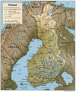
Finland is a state in northern Europe , a member of the European Union and the Schengen Agreement .
A significant part of the territory of Finland lies beyond the Arctic Circle (25%).
The total area is 337,000 km².
On land, it borders with Sweden (the border is 586 km), Norway (the border is 716 km) and Russia (the border is 1265 km).
The coastline is 1100 km long.
The highest point in the country is Haltiatunturi 1328 m.
The country has about 190,000 lakes.
As of 2008, there were 35 national parks in Finland - territories inhabited by rare or valuable species of animals and plants, there are landscape features, and unique natural sites are found. Their total area exceeds eight thousand square kilometers. According to Finnish law, anyone can freely walk around the territory of national parks.