Lake Chad ( French Lac Tchad , English Lake Chad , Arabic. بحيرة تشاد Bukhaira Tshad ) - usually a closed relic lake , located in central Africa in four countries: Chad , Cameroon , Niger and Nigeria . With very rare abnormal increases in the lake level, water begins to flow along the Bahr al-Ghazal channel towards the Bodele Basin [5] .
| Lake | |
| Chad | |
|---|---|
| fr. Lac Tchad Lake chad | |
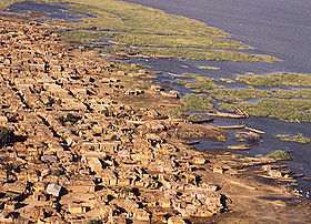 Cameroon village on the shore of Lake Chad | |
| Morphometry | |
| Absolute height | about 240 [1] m |
| Square | 1350 (2005) [2] km² |
| Volume | 72 [3] km³ |
| Coastline | 500-800 [3] km |
| Deepest | 10-11 [3] m |
| Average depth | 1.5 [3] [4] m |
| Pool | |
| Pool area | about 1 million [1] km² |
| Flowing river | Shari |
| Flowing river | Bahr al-Ghazal |
| Location | |
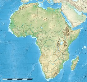
| Country |
|

The lake is located between 12½ and 14½ ° C. w. and 13-15 ° in. from Greenwich, in the southern part of the vast hollow , at an altitude of about 240 m above sea level.
The area of the lake and the water level in it vary greatly from year to year and seasonally, being directly dependent on the influx of water from the rivers feeding the lake, since the lake itself is located in a region with a very arid climate and precipitation provides less than 1/5 of the total the volume of water entering the lake [1] [5] . Until the 60s of the XX century, the area of Lake Chad ranged from 10 to 26 thousand km², but then a sharp reduction in size began, and by the mid-2000s the area of the lake decreased to 1350 km² [2] [4] [6] .
Lake Chad is the largest body of water in the Chad Depression, located in the south of its central part. The lake basin covers an area of approximately 1 million km², while about 700 thousand km² falls on the Shari River basin. Along the shores of the lake lies a network of swamps, which is one of the largest in tropical Africa [1] [5] .
Content
Title
The name comes from a word from the language of the Bornuans - Kanuri , which means big water, a large expanse of water [1] [5] . The Republic of Chad got its name from Lake Chad [7] .
History
According to the Greek geographer of the 2nd century AD e. Marina of Tirsky , extracts from the works of which are preserved in the work of Claudius Ptolemy , circa 100 A.D. e. the governor of Numidia, Julius Matern, together with the king of the nomad Garamantes, made a 4-month journey south through the Sahara to the "land of the Ethiopians Agisimba" and reached the "vast lake" populated by the "many hippos", which, without a doubt, means Lake Chad [8] . Claudius Ptolemy Lake Chad was known under the name "periodically appearing swamp Nuba."
In the geographical composition of the Syrian Arab scientist Abul al-Fida (1273–1331), “Ordering the countries”, Lake Chad is mentioned under the name Lake Quar .
On the maps of the 17th century , in particular on the map of Africa by Olfert Dapper in 1668 [9] and the map of West Africa by Nicolas Sanson in 1679 [10] , at the location of the present Lake Chad, the lake is indicated, which is signed as Borno [5] .
In the XIX century, the first information on the lake was given by Hugh Clapperton , Dickson Denham and Walter Odney (1823); Overegg traveled around (1851) the lake to a group of islets. Lake Heinrich Barth (1852) and Gustav Nachtigal (1870–1872) were more fully investigated.
In 1893-1894, Lake Chad was delimited by the sphere of influence between England , France and Germany : the western shore between Barrois and Mboulou went to the English sphere of influence, the southern shore to the Shari River to the German one, and the east and north of the lake to the French [ 11] [12] .
Lake Description
In its present state, it represents the remnant of a much larger ancient reservoir Mega-Chad , or Paleochad , the water area of which reached 300-400 thousand km². The exact age of Mega-Chad is still being clarified as research has been done (in particular, using radiocarbon analysis ), but it is already known that the area of Chad has increased very much at least three times over the past 12 thousand years [1] [5] . 7 thousand years ago, during the period of maximum spill, Mega Chad stretched one hundred kilometers to the northeast (approximately to Faya Largio ), covering an area of about 1 million km², and was connected to the Atlantic Ocean through the Mayo-Kebi river chain → Benue → Niger . This also explains how manatees entered Lake Chad [13] [14] [15] .
Lake Chad is very shallow [16] , in the northwestern part the average depth of the lake varies between 4-8 meters (the deepest point of the lake, reaching only 10-11 meters, is located there), in the southeast of the lake the average depth is 2-4 m [3] . The average depth of the whole lake is about 1.5 [3] [4] —2 [1] [5] m. The surface area of the lake is unstable, but until the 60s of the XX century it usually occupied about 27 thousand km² in the rainy season spilling up to 50 thousand km², and in the dry - decreasing to 11 thousand km². From the south, the Shari rivers with a wide and shallow delta and the shallow Mbuli [17] (Mbulu [11] ) flow into the lake, from the west - Komadugu-Yobe and from the east the wadi Bahr el-Ghazal approaches the lake. The water in the lake is replenished mainly due to the rivers flowing into it, the largest of which is the Shari, it accounts for about 98% of the water entering the lake from the rivers. The average annual amplitude of fluctuations in the lake level is usually in the range 0.6–0.8 m, and in wet years it reaches 2 m or more [1] [5] . The highest water levels occur in December - January (November - December [1] [5] ), when the water flow in Shari increases to a maximum, then a gradual decline begins, reaching a minimum in June - July [1] [5] [11] [18] . Open water spaces in the northwest, south, and southeast of the lake are separated by shoals (which are partially flooded ancient dunes) [18] .
The sharp decrease in the lake area observed in recent decades is explained by many factors, as the main ones can be distinguished:
- an increase in the solid runoff of the flowing rivers, which leads to an acceleration in the filling of the lake with sediments, associated with increased soil erosion due to the destruction of woody vegetation due to the use of the fire system of agriculture and overgrazing.
- sharply increased water intake both from the lake itself and from the rivers feeding it, for water supply to an ever-growing population and irrigation of fields.
- climate change, for example, in the 1970s, the long-term drought that contributed to the Sahel and some other parts of Africa contributed to the reduction in the area of the lake [4] [5] [19] .
Due to the variability of the size of the lake, the outlines of its shores are constantly changing, but some of the most characteristic features remain. The western and southern shores are relatively straightforward and have only a few significant peninsulas. On the contrary, the northern and especially eastern shores are strongly indented, and numerous islands are located along them, representing semi-submerged sand dunes [1] [5] . The shores of the lake are gently sloping, in many places swampy, on the northern side are framed by sand dunes [18] , to the northeast the area has the character of a steppe, and only the southern shore is rich in tropical vegetation [11] .
Fresh water in the lake is concentrated near the mouths of the flowing rivers, in other places it is brackish, while at the depth the salinity of the water is significantly higher than at the surface. Since Lake Chad has no runoff to the ocean and is located on the border with the desert, for a long time it remained a mystery the reason for maintaining a low level of salinity in it. It was finally resolved only after confirming the existence of an underground runoff of infiltration water to the northeast, towards the Bodele Basin , the existence of which Nachtigal had supposed. A significant role in reducing water mineralization is played by the process of salt crystallization taking place in the northeast of the lake. In addition, if during the rainy season there is a lot of rainfall, which happens extremely rarely, and the water level increases extremely, a temporary surface runoff is formed - also to the northeast, through the wadi Bahr al-Ghazal towards the Soro and Bodele basins. Over the past century and a half, this phenomenon has been observed only twice. For the first time in 1870, then the water from Lake Chad passed through the Wadi for 100 km. The second time this happened in the 50s of the last century, that is, after more than 80 years, when heavy rains in the southern part of the lake basin caused an increase in the water level in Chad by 1 m, which led to the filling of Bahr al-Ghazal [1 ] [5] [11] .
The lake is known for its floating islands .
Climate
The average rainfall in the lake region is 200-500 mm per year [1] [5] .
Flora
More than 1000 species of algae were found in the lake [20] . The shallows are covered with thickets of reed, papyrus [18] . Lake Chad with its surrounding reservoirs is one of the few remaining natural spirulina habitats in the world.
Fauna
In the basin of Lake Chad, 179 species of fish are found, of which only 25 species are endemic , the rest are also found in the basins of the Nile , Congo and Niger [21] .
Manatees [19] , hippos , crocodiles are found in the lake; the fauna of water and bog birds is widely represented [18] .
Population
The groups of the islands of Buduma, Karka and Kuri, located in the eastern part of the lake, are inhabited by people from neighboring tribes (Buduma, Kuri, Kanemba, Kanuri, Bulala and Dats) [11] .
Minerals
On the northeast coast of Lake Chad there are deposits of natural soda (6 million tons). Salt and caustic soda (natron) are being mined [18] . In the 1970s, Chevron, Conoco, Exxon, and Shell explored oil and gas exploration in the lake area, as a result of which three oil fields Sedizhi, Kanem, and Kumia were discovered [22] .
Economic value
Locals have long used spirulina in their diet, traditionally collecting it from the numerous lakes and ponds surrounding Lake Chad, then the algae mass is pressed into cakes called dihé , which are later used for direct consumption, and as an ingredient for cooking soups [19] [ 23] .
The lake is a zone of intensive fishing, fishing is carried out year-round (annual fishing in the second half of the XX century - about 100 thousand tons). Used for navigation between the mouths of the Shari and Komadugu-Yobe rivers. Lake waters play a large role in the water supply of the surrounding areas [18] .
Current Status
Since the beginning of the 1960s, there has been a sharp decrease in the area of the lake due to climate change and the active use of its water by people and in agriculture. In 1963, the area of the lake was estimated at 25 thousand km², by 1973 it was reduced to 15.4 thousand, in 1982 it amounted to slightly less than 2.3 thousand, and in 1994 - already 1.7 thousand. During the 1980s and early 1990s, the use of lake water for irrigation increased 4 times [6] .
By 2006, the lake decreased by 26 times and continued to dry out, which became known thanks to the Earth monitoring carried out by the international system “Disaster Monitoring Constellation” ' [19] '.
NASA employees also reported the drying up of Lake Chad, comparing satellite images from 2001 with images taken 38 years ago [19] .
Chad is known to dry out for the seventh time in the last millennium [19] . Paleontologists have established this from the remains of animals found there.
Satellite imagery taken by the first Nigerian satellite Nigeria Sat-1 became part of the History of the Dying Lake exhibition held in Abuja , the capital of Nigeria.
Projects are being developed to transfer part of the runoff from the Congo basin (in particular, Ubangi ), from 15 to 100 km³ per year [19] [24] .
In art
Jules Verne describes Lake Chad in his novel Five Weeks in a Balloon (1863): “The shores of the lake are covered with almost impassable swamps - Bart almost died in them - and these swamps, overgrown with reeds and papyrus fifteen feet high , from time flooded by the waters of the lake. Even local coastal cities are often flooded, as happened in 1856 with the city of Ngornu; hippos and alligators are now diving in the very places where the houses of the inhabitants of Bornu have recently risen . Dazzling rays of the sun poured on the still waters of the lake, closing in the north with the horizon. The doctor wished to try the water - for a long time it was considered salty ... ” (31 Ch.)
Notes
- ↑ 1 2 3 4 5 6 7 8 9 10 11 12 13 Dmitrevsky Yu. D. Inland waters of Africa and their use .. - Leningrad: Gidrometeoizdat, 1967. - 380 p.
- ↑ 1 2 Lake Chad: Experiences and Lessons Learned Brief (PDF). Managing lakes and their Basins for Sustainable Use . International Lake Environment Committee (ILEC) Foundation (2005). Date of treatment February 15, 2008.
- ↑ 1 2 3 4 5 6 Lake Chad (unavailable link) . World Lakes Database . International Lake Environment Committee (ILEC) (1983). Date of treatment November 20, 2015. Archived November 20, 2015.
- ↑ 1 2 3 4 Vanishing Lake Chad — a water crisis in central Africa (English) // WaterNews: journal. - 2008 .-- 24 June. Archived on May 2, 2009.
- ↑ 1 2 3 4 5 6 7 8 9 10 11 12 13 14 Dmitrevsky Yu.D., Oleinikov I.N. Lakes of Africa. - Leningrad: Gidrometeoizdat, 1979. - 184 p. - 35,000 copies.
- ↑ 1 2 Lake Chad: almost gone ( link unavailable) . VITAL WATER GRAPHICS. An Overview of the State of the World's Fresh and Marine Waters - 2nd Edition . UNEP (2008). Date of treatment September 18, 2015. Archived December 16, 2008.
- ↑ "Chad". Encyclopædia Britannica . (2000)
- ↑ Julius Matern in Lake Chad
- ↑ Olfert Dapper. Naukeurige Beschrijvingen der Afrikaensche gewesten . - 1668. + Index - Map of Africa Olfert Dapper 1668
- ↑ Africa or Great Libya . wdl.org. - Description of the map of Nicolas Sanson. Date of treatment November 23, 2015.
- ↑ 1 2 3 4 5 6 Chad // Brockhaus and Efron Encyclopedic Dictionary : in 86 volumes (82 volumes and 4 additional). - SPb. , 1903. - T. XXXVIII. - S. 362.
- ↑ History of the discovery of Lake Chad
- ↑ Leblanc et al. 2006 Reconstruction of megalake Chad using shuttle radar topographic mission data. Palaeogeography, palaeoclimatology, palaeoecology 239, pp. 16-27 ISSN 0031-0182 1872-616X
- ↑ Stewart, Robert Dustiest places on Earth — dead and dying seas (link not available) . Environmental Science in the 21st Century. A New Online Environmental Science Book for College Students (July 28, 2009). Date of treatment November 20, 2015. Archived on April 30, 2016.
- ↑ Drake, Nick; Bristow, Charlie. Shorelines in the Sahara: geomorphological evidence for an enhanced monsoon from palaeolake Megachad (Eng.) // The Holocene: journal. - 2006. - Vol. 16 , no. 6 . - P. 901-911 . - DOI : 10.1191 / 0959683606hol981rr .
- ↑ Chad // Dictionary of modern geographical names / Rus. geo about . Mosk. Centre; Under the total. ed. Acad. V.M. Kotlyakova . Institute of Geography RAS . - Yekaterinburg: U-Factoria, 2006.
- ↑ Map sheet D-33-B . Scale: 1: 500,000 .
- ↑ 1 2 3 4 5 6 7 Africa: Encyclopedic Reference / Anatoly Gromyko. - 2nd ed. - Soviet Encyclopedia, 1986-1987. - 1344 p. - 57,000 copies.
- ↑ 1 2 3 4 5 6 7 How Lake Chad disappears . rg.ru. Date of treatment November 17, 2015.
- ↑ Colette Serruya, Utsa Pollingher. Lakes of the Warm Belt . - Cambridge Univ. Press, 1983. - P. 274. - ISBN 9780521233576 .
- ↑ Hughes ,, RH A Directory of African Wetlands . - IUCN, 1992. - P. 463. - ISBN 9782880329495 .
- ↑ Raw materials complex of foreign countries. Chad . mineral.ru. Date of treatment November 17, 2015.
- ↑ Abdulqader, G., Barsanti, L., Tredici, M. “Harvest of Arthrospira platensis from Lake Kossorom (Chad) and its household usage among the Kanembu.” Journal of Applied Phycology . 12: 493-498. 2000.
- ↑ World Water Congress 2008
Literature
- Boyd Alexander, "From Niger to the Nile" (diary of the first British expedition to Lake Chad in 1904-1907) on africastolet.ru
- Barth, “Reisen und Entdeckungen in Nord- und Centralafrika” (Gotha, 1855-58);
- Beadle L. C., The inland waters of tropical Africa, L., 1974.
- Nachtigal, "Sahara und Sudan" (B. and Lpts., 1879-89).
- Dmitrevsky Yu. D. Inland waters of Africa and their use / Otv. ed. M.S. Rozin . - L .: Gidrometeoizdat , 1967 .-- 384 p. - 800 copies.
- Dmitrevsky Yu.D. , Oleinikov I.N. Lakes of Africa . - L .: Gidrometeoizdat , 1979. - 184, [32] p. - 35,000 copies.
- Chad // Brockhaus and Efron Encyclopedic Dictionary : in 86 volumes (82 volumes and 4 additional). - SPb. , 1903. - T. XXXVIII. - S. 362.
- Chad // Great Soviet Encyclopedia : in 66 volumes (65 volumes and 1 additional) / Ch. ed. O. Yu. Schmidt . - M .: Soviet Encyclopedia , 1926-1947.
Links
- Chad (lake) - article from the Great Soviet Encyclopedia .
- Campbell, Robert Wellman Lake Chad, West Africa: 1963, 1973, 1987, 1997, 2007. (English) . USGS (2008). Date of treatment January 14, 2010. Archived on February 9, 2012.
- Lake Chad ( inaccessible link) . International Lake Environment Committee. Date of treatment January 14, 2010. Archived on February 6, 2010.
- Lake Chad as seen from Apollo-7 in 1968