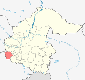
The Isaetsky District is an administrative-territorial unit ( district ) and a municipality ( municipal district ) in the Tyumen Oblast of Russia .
| district [1] / municipal district [2] | |||||
| Iset district | |||||
|---|---|---|---|---|---|
| |||||
| A country | |||||
| Enters into | Tyumen region | ||||
| Includes | |||||
| Adm Centre | Iset village | ||||
| The head of administration | Tenkovsky Nikolay Vladimirovich | ||||
| Chairman of the Duma | Zelenina Oksana Sergeevna | ||||
| History and geography | |||||
| Date of education | 1923 | ||||
| Square | 2751.20 [3] km² | ||||
| Timezone | MSK + 2 ( UTC + 5 ) | ||||
| Population | |||||
| Population | ↘ 25 318 [4] people ( 2018 ) (0.68%) | ||||
| Density | 9.2 p / km² | ||||
| Digital identifiers | |||||
| Telephone code | 34537 | ||||
| Official site | |||||
 | |||||


The administrative center is the village of Isetskoe .
Content
Geography
Iset district is located in the southwestern part of the Tyumen region. Borders: in the south-west - with the Kurgan region , in the north-west - with the Sverdlovsk region , as well as with the Tyumen, Yalutorovskiy and Uporovsky districts of the Tyumen region. The area of the district is 2751.2 km².
Population
| Population | ||||||
|---|---|---|---|---|---|---|
| 2002 [5] | 2009 [6] | 2010 [7] | 2011 [8] | 2012 [9] | 2013 [10] | 2014 [11] |
| 26 565 | ↘ 25,905 | ↗ 26,061 | ↘ 26,051 | ↘ 25,819 | ↘ 25,734 | ↘ 25 693 |
| 2015 [12] | 2016 [13] | 2017 [14] | 2018 [4] | |||
| ↗ 25,849 | ↘ 25,770 | ↘ 25,661 | ↘ 25,318 | |||
History
Formed on the basis of decisions of the Central Executive Committee on 3 and 12 November 1923 the year as part of the Tyumen district of the Ural region of Arkhangelsk, Bobylevskoy, Upper Beshkilskoy, Denisov, Iset, Krasnovskii, Krasnogorsk, Mininskoy, Slobodobeshkilskoy and Shorohovskoy townships Yalutorovsk district of the Tyumen province .
The area includes 27 village councils: Arkhangelsk, Arkhangelsk. Splyvaevsky, Stanichensky, Sungurovsky, Terenkulsky, Shorokhovsky.
By a decree of the regionalization committee at the district executive committee of June 7, 1924, the Logovskiy Village Council was formed.
By decrees of the All-Russian Central Executive Committee of January 17, 1934, the district became part of the Chelyabinsk Region .
On December 7, 1934, the district was transferred to the Omsk Region .
On October 20, 1937, the Verkh-Ingalinsky Village Soviet was transferred from the Yalutorovsky district .
Decrees of the Presidium of the Supreme Soviet of the RSFSR of September 7, 1939 transferred the Turushevsky village council from the Shatrovsky district of the Chelyabinsk region; On September 19, 1939, Bobylevsky, Verkh-Ingalinsky, Gaevsky, Yershinsky, Logovsky, Malyshevsky, Sizikovsky, Sungurovsky and Yurt-Sungurovsky village councils were abolished.
February 6, 1943 - the district is included in the Kurgan region .
August 14, 1944 - transferred to the educated Tyumen region .
On June 17, 1954, the Barkhatovsky, Batenevsky, Isetsky, Kirsanovsky, Krasnogorsky, Slobodobeshkilsky, Splyvaevsky and Stanichensky village councils were abolished. Lobanovsky and Turushevsky village councils are united in Bobylevsky. February 23, 1956 formed Kommunarovskiy village council. December 8, 1960 Terenkulsky village council renamed Isetsky. July 18, 1961 Arkhangelsk, Onufrievsky and Shorokhovsky village soviets were abolished. On February 1, 1963, the district was abolished. The territory became a part of Yalutorovskiy enlarged rural area . December 30, 1966 the district was formed again in the same composition. On July 20, 1967, Barkhatovsky and Slobodobeshkilsky Village Councils were formed. March 28, 1987 was formed by the Kirov Village Council. On May 25, 1991, the Arkhangelsk Village Council was formed. March 13, 1992 Verkh-Ingalsky village council was formed. The Duma of the Isetsky municipal district of the 3rd convocation (2010-2015) consists of 32 deputies, 31 deputies represent the party "United Russia" and 1 from the Liberal Democratic Party.
Municipal unit
There are 16 rural settlements in Isetsky municipal district, including 41 settlements:
| No | Rural settlements | Administrative center | amount inhabited points | Population | Square, km 2 |
|---|---|---|---|---|---|
| one | Arkhangelsk rural settlement | Arkhangelskoye village | one | ↘ 801 [14] | 67.97 [3] |
| 2 | Barkhatovskoye rural settlement | Barkhatovo village | 3 | ↘ 1172 [14] | 123.31 [3] |
| 3 | Bobylevskoe rural settlement | village Bobylevo | five | ↘ 796 [14] | 119.08 [3] |
| four | Verkhnebeshkilskoye rural settlement | Verkhnebeshkil village | 2 | → 617 [14] | 78.29 [3] |
| five | Verkhneingalskoye rural settlement | village Upper Ingal | one | ↘ 480 [14] | 32.71 [3] |
| 6 | Denisov rural settlement | Denisovo village | one | ↘ 512 [14] | 228.36 [3] |
| 7 | Isetskoe rural settlement | Iset village | 2 | ↗ 7515 [14] | 54.23 [3] |
| eight | Kirov rural settlement | Kirovsky settlement | one | ↘ 1001 [14] | 27.61 [3] |
| 9 | Kommunarovskoe rural settlement | village Kommunar | 3 | ↘ 1999 [14] | 174.22 [3] |
| ten | Krasnovskoye rural settlement | Krasnovo village | five | ↘ 1269 [14] | 376.04 [3] |
| eleven | Mininskoe rural settlement | Minino village | 3 | ↘ 1026 [14] | 150.21 [3] |
| 12 | Rassvetovskoye rural settlement | Rassvet village | one | ↘ 1055 [14] | 137.05 [3] |
| 13 | Rafaylovskoye rural settlement | village Rafaylovo | four | ↘ 1580 [14] | 172.14 [3] |
| 14 | Slobodobeshkilskoye rural settlement | village Sloboda-Beshkil | one | ↘ 1315 [14] | 160.33 [3] |
| 15 | Soloboevskoye rural settlement | village Soloboevo | five | ↗ 2158 [14] | 434.16 [3] |
| sixteen | Shorokhovskoye rural settlement | Shorokhovo village | 3 | ↘ 2365 [14] | 415.49 [3] |
Locations
| List of settlements of the district | ||||
|---|---|---|---|---|
| No | Locality | Type of | Population | Municipality |
| one | Arkhangelsk | village | ↘ 801 [14] | Arkhangelsk rural settlement |
| 2 | Barkhatovo | village | 707 [7] | Barkhatovskoye rural settlement |
| 3 | Bateni | village | 125 [7] | Rafaylovskoye rural settlement |
| four | Bityuki | village | 187 [7] | Rafaylovskoye rural settlement |
| five | Bobylevo | village | 490 [7] | Bobylevskoe rural settlement |
| 6 | Botniki | village | 148 [7] | Soloboevskoye rural settlement |
| 7 | Verkhnebeshkil | village | 591 [7] | Verkhnebeshkilskoye rural settlement |
| eight | Upper Ingal | village | ↘ 480 [14] | Verkhneingalskoye rural settlement |
| 9 | Gaev | village | 302 [7] | Barkhatovskoye rural settlement |
| ten | Denisovo | village | ↘ 512 [14] | Denisov rural settlement |
| eleven | Ershina | village | 177 [7] | Krasnovskoye rural settlement |
| 12 | Grain | village | 150 [7] | Shorokhovskoye rural settlement |
| 13 | Iset | village | ↗ 7479 [7] | Isetskoe rural settlement |
| 14 | Ishim | village | 160 [7] | Shorokhovskoye rural settlement |
| 15 | Kirovsky | village | ↘ 1001 [14] | Kirov rural settlement |
| sixteen | Kirsanova | village | 69 [7] | Krasnovskoye rural settlement |
| 17 | Communard | village | 1517 [7] | Kommunarovskoe rural settlement |
| 18 | Krasnovo | village | 622 [7] | Krasnovskoye rural settlement |
| nineteen | Krasnogorskoe | village | 251 [7] | Soloboevskoye rural settlement |
| 20 | Cuckoo | village | 390 [7] | Kommunarovskoe rural settlement |
| 21 | Lobanov | village | 174 [7] | Bobylevskoe rural settlement |
| 22 | Log | village | 193 [7] | Mininskoe rural settlement |
| 23 | Little kids | village | 207 [7] | Soloboevskoye rural settlement |
| 24 | Marino | village | 10 [7] | Isetskoe rural settlement |
| 25 | Minino | village | 766 [7] | Mininskoe rural settlement |
| 26 | Mirolyubova | village | 60 [7] | Kommunarovskoe rural settlement |
| 27 | Novikova | village | 347 [7] | Krasnovskoye rural settlement |
| 28 | Onufrievo | village | 139 [7] | Mininskoe rural settlement |
| 29 | Osinova | village | 22 [7] | Bobylevskoe rural settlement |
| thirty | Shepherd | village | 24 [7] | Verkhnebeshkilskoye rural settlement |
| 31 | Dawn | village | ↘ 1055 [14] | Rassvetovskoye rural settlement |
| 32 | Rafaylovo | village | 1226 [7] | Rafaylovskoye rural settlement |
| 33 | Reshetnikova | village | 120 [7] | Krasnovskoye rural settlement |
| 34 | Sizikova | village | 101 [7] | Bobylevskoe rural settlement |
| 35 | Sloboda-Beshkil | village | ↘ 1315 [14] | Slobodobeshkilskoye rural settlement |
| 36 | Sozonova | village | 31 [7] | Bobylevskoe rural settlement |
| 37 | Soloboevo | village | 1204 [7] | Soloboevskoye rural settlement |
| 38 | Stanichnoe | village | 414 [7] | Soloboevskoye rural settlement |
| 39 | Turushevo | village | 128 [7] | Barkhatovskoye rural settlement |
| 40 | School | village | 84 [7] | Rafaylovskoye rural settlement |
| 41 | Shorokhovo | village | 2068 [7] | Shorokhovskoye rural settlement |
Attractions
Heritage sites
- monuments of archeology of federal significance in the Ingalsky valley - the settlements of Kolovskoye and Slobodo-Beshkilskoye, the burial site Krasnogorsky-I, the settlements of Kolovskoe-I and Kolovskoe-II
- architectural monument of federal importance
Specially Protected Natural Areas
- complex zoological reserve of regional significance " Rafailovsky " (16 750 ha)
- Regional natural monument Marino gorge (27 hectares) in the Ingalskaya valley
Notes
- ↑ from the point of view of the administrative-territorial structure
- ↑ from the point of view of the municipal structure
- ↑ 1 2 3 4 5 6 7 8 9 10 11 12 13 14 15 16 17 (Tyumen region. Total land area of the municipality
- ↑ 1 2 The population of the Russian Federation by municipalities as of January 1, 2018 . The appeal date was July 25, 2018. Archived July 26, 2018.
- ↑ All-Russian census of 2002. Tom. 1, table 4. The population of Russia, federal districts, constituent entities of the Russian Federation, districts, urban settlements, rural settlements — regional centers and rural settlements with a population of 3,000 or more . Archived on February 3, 2012.
- ↑ The resident population of the Russian Federation by cities, urban-type settlements and districts as of January 1, 2009 . The date of circulation is January 2, 2014. Archived January 2, 2014.
- ↑ 1 2 3 4 5 6 7 8 9 10 11 12 13 14 15 16 17 18 19 20 21 22 23 24 25 26 27 28 29 30 31 32 33 34 35 36 National Population Census 2010. Population size and its location in the Tyumen region . The date of circulation is May 10, 2014. Archived May 10, 2014.
- ↑ Tyumen region. Estimate of the number of resident population on January 1, 2009-2016
- Population of the Russian Federation by municipalities. Table 35. Estimated number of resident population on January 1, 2012 . The date of circulation is May 31, 2014. Archived May 31, 2014.
- ↑ Population of the Russian Federation by municipalities as of January 1, 2013. - M .: Federal State Statistics Service Rosstat, 2013. - 528 p. (Table 33. Population of urban districts, municipal districts, urban and rural settlements, urban settlements, rural settlements) . The appeal date is November 16, 2013. Archived November 16, 2013.
- ↑ Table 33. The population of the Russian Federation by municipalities as of January 1, 2014 . Circulation date August 2, 2014. Archived August 2, 2014.
- ↑ Population of the Russian Federation by municipalities as of January 1, 2015 . Circulation date August 6, 2015. Archived August 6, 2015.
- Population of the Russian Federation by municipalities as of January 1, 2016
- ↑ 1 2 3 4 5 6 7 8 9 10 11 12 13 14 15 16 17 18 19 20 21 22 23 Population of the Russian Federation by municipalities as of January 1, 2017 (July 31, 2017). The date of circulation is July 31, 2017. Archived July 31, 2017.
Literature
- Administrative and territorial division of the Tyumen region (XVII — XX centuries). - Tyumen, 2003. - 304 p. - ISBN 5-87591-025-9 .
- Yemelyanov, AL The history of Priisetya. - Tyumen, 2006. - 328 p. - ISBN 5-93020-374-1 .
- Edge native. 75 years Iset district. - Isetsk, 1998. - 40 p.
- Russian on Iset. - Shadrinsk, 1999. - 160 p.
Links
- Iset district on the portal of public authorities of the Tyumen region
- Iset district . Tourist resources of the Tyumen region. The appeal date is May 10, 2012. Archived on May 27, 2012.
- Iset district on the website "Business World of Siberia"