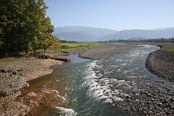
Khobi ( Georgian. ხობი ) in the upper reaches - Khobistskali ( ხობისწყალი ) is a river in Georgia . The length of the river is 150 km, the basin area is 1340 km². [1] [2]
| Hobi | |
|---|---|
| cargo. ხობი | |
 | |
| Characteristic | |
| Length | 150 km |
| Pool | 1340 km² |
| Water consumption | 60.1 m³ / s |
| Watercourse | |
| Source | |
| • Location | Egris Range |
| • Coordinates | |
| Mouth | Black Sea |
| • Height | 0 m |
| • Coordinates | |
| Location | |
| A country |
|
| Region | Samegrelo-Upper Svaneti |
| Areas | Chkhorotsk municipality , Khob municipality |

The source is located in the southern part of the Egris Range [3] ; the river flows along the Colchis Lowland and flows into the Black Sea [4] . On Khobi is the city of Khobi , the village of Chkhorotsku , near the mouth - the village of Kulevi .
The food is mostly rain. The average water discharge (30 km from the mouth) is 44.2 m³ / s, the maximum is 333 m³ / s.
The main tributary is Chanistskali (right). The Khobi River is used for irrigation.
During the Great Patriotic War, at the mouth of the Khobi River there was a temporary base for part of the Black Sea Fleet [5] .
In 2000-2005, at the mouth of the Khobi River near the village of Kulevi, an oil terminal was built for tankers .
Notes
- ↑ Gigineishvili G., Georgian Soviet Encyclopedia , Volume 11, Art. 492, Tbilisi , 1987.
- ↑ Khobi (river) - an article from the Great Soviet Encyclopedia .
- ↑ Map sheet K-38-37-B . Scale: 1:50 000. Indicate the date of issue / condition of the area .
- ↑ Map sheet K-37-72-A . Scale: 1:50 000. Indicate the date of issue / condition of the area .
- ↑ Kumanin M.F.