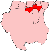
Para ( Dutch: Para ) is the county of Suriname , located in the northern part of the country. The administrative center is the city of Onvervaht . Other cities are Paranam , Sabana and Zanderei .
| County | |
| Couple | |
|---|---|
| niderl. Para | |
| A country | |
| Includes | 5 communes |
| Adm. Centre | Onverwacht |
| History and Geography | |
| Square | 5 393 km² (3rd place ) |
| Timezone | UTC -3 |
| Population | |
| Population | 18 749 people ( 2004 ) ( 6th place ) |
| Density | 3.48 people / km² (7th place) |
| Digital identifiers | |
| ISO 3166-2 Code | SR-PR |
 | |
The population of the district is 18 749 people (2004), the area is 5393 km² [1] .
History
The ruins of the city of Jodensavann are in Par County. Jews fleeing the Spanish Inquisition founded the Jodensavanne in the 17th century , but the settlement was destroyed by fire in 1832 . Interestingly, during the Second World War , a concentration camp for suspects in Nazism was located in Jodensavann.
Administrative Division
| No. | Commune | Population, people (2004) | Square, km² |
|---|---|---|---|
| one | Noord-Para | 6442 | 236 |
| 2 | Oost-Para | 7349 | 446 |
| 3 | Zuid-Para | 4403 | 909 |
| four | Bigi Poika | 335 | 2361 |
| five | Carolina (Carolina) | 220 | 1441 |
| Total | 18,749 | 5393 |
Economics
Par County is the center of Suriname's woodworking and mining industry with a large number of working mines.
In Par County there is a source attributed to beneficial medical qualities.
Notes
- ↑ Censimento 2012 da GeoHive.com . Archived on April 5, 2013.