A closed region is a part of the land that does not have a connection through river systems with the oceans . A river basin located inside such an area is called a closed or closed basin . The bottom of such a basin, as a rule, is occupied by a closed lake — a lake that does not have surface runoff or underground water drainage into neighboring catchments . Such lakes are salty or even dried salt marshes .
Moisture resulting from rains (or other precipitation ) falling in the drainless area can leave the pool only through evaporation or seepage . Most often, closed lakes are located in closed areas of the steppe and semi-desert zones, as well as in areas of continuous distribution of permafrost . The largest drainage areas are in Africa and Asia . The total area of all drainage areas is about 18% of all land.
Distribution
Inland areas can occur in any climate, but most of them are located in hot deserts . In regions with a large amount of precipitation, water erosion (especially during floods ) creates channels through geographical barriers that separate the drainless hydrological system. It is likely that the Black Sea was such an isolated system before the barrier separating it from the Mediterranean Sea was broken.
Inland regions are usually located deep within the continents . Their borders pass through mountains and other geological objects that separate them from the oceans. Since water can only leave through evaporation or seepage, in the drainless areas there is a process of accumulation of minerals and other products, as a result of which the water becomes salty and the entire pool is very sensitive to pollution . The number of drainless regions on each of the continents is different and is determined by geographical and climatic conditions. In Australia, drainless regions account for 18% of the total territory, in North America - only 5%. [1] About 18% of the total land area belongs to landlocked areas, the largest of which are located in Asia.
In deserts, evaporation can go more intensively than the arrival of new water, which is why the formation of a full-fledged river basin is impossible. Minerals brought by water after its evaporation are deposited, which leads to the formation of salt marshes . These areas are so large that their hard, flat surface is sometimes used as runways or for setting speed records on the ground.
Inland areas can be formed by both permanent and seasonal inland lakes. Some areas are so stable that climate change (reduced rainfall) inhibits lake formation. Most permanent inland lakes can change in size and shape over time, becoming smaller or dividing into several parts during a drought. In the course of human development of previously uninhabited desert regions, the nourishing internal lakes of the river are changed by dams and water pipelines. As a result, the volume of many drainless lakes in developed and developing countries has greatly decreased, which is why the concentration of salts and pollutants in them has increased, which has led to disturbances in their ecosystems.
Large Inland Pools and Lakes
Antarctica
Inland Antarctica lakes are located in the dry valleys of McMurdo and in the Victoria Land area .
- Lake Don Giovanni in the Wright Valley is fed by groundwater from a stone glacier, does not freeze.
- Wanda Lake in the Wright Valley is covered with ice all year round, the edges of which thaw in the summer, which allows the Onyx River (the longest river in Antarctica) to flow into the lake. The lake is hyperhaline (saline) and has a depth of 70 m.
- Bonnie Lake in the Taylor Valley is ice-covered year-round and is fed by glacial waters. Its unique glacial history led to stratification - salt water is near the bottom, fresh - at the surface.
- Hoar Lake in the Taylor Valley is the freshest of all the Dry Lakes lakes, feeding mainly on Canada glacier. The lake is covered with ice, which thaws during the summer, forming a moat with water.
- Freexell Lake is located in the Taylor Valley near the Ross Sea . The lake is covered with ice and feeds on numerous meltwater for about 6 weeks a year. The salinity of the lake increases with depth.
Asia
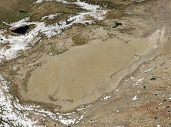
Most of western and central Asia is one large inland pool.
- The Central Asian Inland Basin is the largest of the three basins in Mongolia .
- The Caspian Sea is the largest enclosed body of water on Earth . Most of the East European Volga basin also belongs to this basin.
- Aral Sea , the tributaries of which were used for industrial purposes, which led to a significant drying out of the lake . An environmental disaster has drawn public attention to the state of drainage pools.
- Lake Balkhash in Kazakhstan .
- The system of lakes Alakol , which includes lakes Sasykkol , Zhalanashkol and Uyaly in the eastern part of the Balkhash-Alakol depression near the Dzungarian gate .
- Tengiz Lake basin in the western part of Sary-Arka . In some years, part of the runoff overflows into Ishim - that is, the internal drainage basin is partially connected to the basin of the Arctic Ocean .
- Issyk-Kul and Chatyr-Kul lakes in Kyrgyzstan .
- Sistan basin located on the territory of Iran and Afghanistan .
- Tarim basin (historically, the Lob Nor Lake basin), located in the far west of China.
- Tsaidam basin, in Qinghai province in western China .
- Kukunor Lake Basin, in Qinghai Province in Western China .
- The basin of the Dzhungar plain in East Turkestan , the center of which is Lake Ebi-Nur .
- Ubsu-Nur basin , located in Mongolia and the Russian Republic of Tuva .
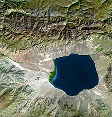
- The Dead Sea is the lowest point on the land surface on Earth, and one of the most saline reservoirs is located between Israel and Jordan .
- Van Lake , located on the Armenian Highlands in eastern Turkey .
- Sambhar Lake in Rajasthan in northwestern India is also a closed lake.
- Sarykamysh lake in the northern part of the Karakum desert on the border of Turkmenistan and Uzbekistan , which arose as a result of the discharge of part of the Amu Darya flow into the Sarykamysh depression.
- The Mar-Kuel Plateau in the Far East, located in the Ayano-May district of the Khabarovsk Territory .
Australia
Australia has a dry climate, so there are many drainage pools on its territory. The largest of them:
- The Lake Air basin also includes Lake From .
- Lake Torrens , located west of the Flinders Range in South Australia .
- Korangamit Lake is a highly saline volcanic lake in western Victoria .
- Lake George , previously connected to the Murray-Darling Basin.
Africa
- Turkana Lake in Kenya .
- The Okavango Delta is a drainless inland delta in the Kalahari Desert , Botswana .
- Ngami Lake in Botswana.
- Lake Chad , located between the states of Chad and Cameroon . It feeds on the Shari and Logon rivers.
- Etosha Solonchak , located in Etosha National Park , Namibia .
- Qattara Depression in Egypt .
- Chott Melgir Lake in Algeria .
- Chilwa Lake in Malawi .
- Afar Depression in Eritrea , Ethiopia and Djibouti .
Europe
- Lake Neusiedlersee in Austria and Hungary .
- Lake Trasimeno in Italy
- Lake Velenz in Hungary
- Lake Prespa in the territory of the states of Albania , Greece and the Republic of Macedonia
All these lakes have a drain, however, through artificial channels or through the karst phenomenon.
North America
- Mexico City Valley - in pre-Columbian times, the valley was covered with five lakes, including Lake Texcoco , Lake Shochimilco and Lake Chalko .
- Crater Lake in Oregon .
- The Great Basin is the largest drainage region in North America , which includes:
- Black Rock Desert
- Death Valley
- Big Salt Lake
- Utah Lake Sevier
- Pyramid Lake in Nevada
- Mono Lake in California
- Guzman Basin , located in the south of the USA and the north of Mexico
- Bolson de Mapi , located in northern Mexico
- Lake Atitlan in the highlands of Guatemala
South America
- Altiplano pool is one of the largest and highest in the world.
- Lake Valencia , the second largest in Venezuela .
- Atacama Solonchak , located in the Atacama Desert , Chile
Ancients
Some of the ancient drainless systems of the Earth:
- Black Sea before joining the Mediterranean Sea .
- The Mediterranean Sea and all its tributaries in the Messinian period of the Miocene era, when the Mediterranean Sea partially evaporated (about 6 million years ago).
- Lahontan Lake in the western United States.
- The Ebro and Duero basins, irrigating most of northern Spain during the Neogene Period.
- Lake Bonneville in Utah .
Notes
Links
- Drain-free areas - article from the Great Soviet Encyclopedia .
- Endorheic Lakes: Waterbodies That Don't Flow to the Sea