Exmoor is a geographic area in the west of the county of Somerset and north of the county of Devon in southwestern England , named after the river Ex , originating in the center of the area; The remnant of the ancient royal hunting forest with an area of 76 km² (1815–1818), of which 41.5 km² was allotted to the king in 1815, including the current Exumore community with the parish church in , and in 1818 sold to private hands [1] . In 1954, a national park of 692.8 km² (71% in Somerset, 29% in Devon [2] ) was created, which included the Brendon Hills , , Porlock Valley and 55 km of the Bristol Coast .
| Exmoor | |
|---|---|
| English Exmoor | |
 Porlock Valley | |
| IUCN Category V (Protected Landscape / Water Area) | |
| basic information | |
| Square | 692 km² |
| Founding date | 1954 |
| Managing Organization | Administration of Exmoor National Park in Dalverton |
| Location | |
| A country |
|
exmoor-nationalpark.gov.uk | |


Characteristic natural area
Exmoor has the status of a (HPO) No. 145.
CVD is a division of the natural areas of England based on a combination of features such as landscape, bio-and geo-diversity and economic activities, which are carried out by the British , which advises the British Government on the protection of the environment in England. In total in England there are 159 such areas.
Neighboring with Exmoor HPO: in the southwest, in the south, in the east [3] [4] [5] .
Exmoor National Park
Exmoor became a national park in 1954, according to the [6] . The territory of the national park is a highland, on which there are several remote villages and villages. The largest of them are , , and , almost 40% of the park's population lives in them. Linton and Linmout are united into one community and are connected by a .
Before Exmoor was the royal forest and hunting grounds, but in 1818 the latter were sold out. Several areas of Exmoor became sites of special scientific value due to their flora and fauna. In 1993, an was declared on the territory of Exmoor.
Geology
Exmoor consists of sedimentary rocks : gravelites , sandstones , slate , shale , limestone , aleurite and . These rocks were formed mainly in the Devonian and Carboniferous periods, and the name “Devonian” comes from the name of the county in which Exmoor is located, and the first studies of the Devonian rocks occurred here. Since this region was not exposed to glaciation , the local landscape is quite ancient [7] [8] . Outcrops of iron and quartz rocks are encountered [9] . The bed of the series of sandstones are located in Glentorn. The Hengman sandstones are an example of the Middle Devonian sections of northern Devon and Somerset [10] . Unusual freshwater strata in these rocks were formed in the desert climate [11] . The rocks lying below are covered with mosses and have a loose, sour base [12] . The highest point of Exmoor is the 519-meter , which is also the highest point of Somerset [13] .
Coastline
In Exmoor, the 55-kilometer coast, where the highest seaside cliffs of England are located, reaching 314 meters (in ). However, the ridge of the coastal chain of hills is more than 1.6 km from the sea. If the “cliff” is a hill with a slope of more than 60 °, then the highest cliff of Britain is , located near , 318 meters high, with a cliff more than 250 meters high [13] . Nearby is Little Hengman, 250 meters high, which stands on the border of Exmoor.
The woodlands of Exmoor sometimes stretch ashore [2] , especially often between Porlock and The Foreland , where the longest coastal forest in England and Wales is located [14] . have the status of sites of special scientific importance due to the diversity of plants growing there [15] .
For impressive waterfalls, gorges, cliffs and rocky capes, the Exmur coast in 1991 received the status of a [16] . Local cliffs have one of the longest and most distant traverses in the UK [17] . 1014 km is the longest in England. It starts at and goes along the entire coast [18] [19] . Linmout , and have small harbors. In the old days, they were vital for coastal trade, but in the 21st century they serve mainly for entertainment: private non-commercial pleasure and fishing boats moor there [20] .
The Valley of Stones behind Linton is a deep, dry valley, located parallel to the shore; from the seaside side, at the highest points of the valley, there are many huge stones. The valley, along with the Sexton's Burrows peninsula, forms the natural breakwater of Watermouth Bay.
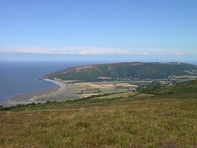
Exmoor coastline near the Valley of Stones
North Devon Coast
View of Leicester Point from Kum-Martin
Rock Laver Stone
Rivers
On the heights are the catchment basins of many rivers and streams. The total length of the named rivers Exmoor is 483 km [21] . The source of the river Aix , which gave the name Exmoorie [22] , is located near the village of , near Bristol Bay , and the river itself flows almost directly to the south, therefore most of its bed is in Devon. Aix flows into the English Channel on the south coast of Devon. Historically, the lowest point of the river was at Exeter , but a viaduct was built to build , three kilometers from the city, and now the lowest point of the river is there. The river has several tributaries that flow to the Exmoor. The Barl River flows from the north of Exmoor to Ex, falling into it at Exebridge. The Barl River and are areas of special scientific significance . Another tributary, the , flows out of .
Most of the other rivers flow north into the Bristol Bay. Among them , stretching along the western borders of Exmoor [23] and the rivers and , occurring at Linmouth . Hoar Oak Water is a marshy East-Lin tributary that flows into it at Watersmeet [24] . The Horner River ( born Horner ) originates from and flows into . The exception of the rivers flowing to the north is the tributary of the , the Mole.
River horner
Place confluence Ho-Oak in Lin
Span Head Creek
Bridge over Lin in Linmouth
Climate
Horner Woods in winter
North Molton at the end of September
Kum-Martin, mid May
Like the rest of South West England , Exmoor is located in a temperate zone , softer and more humid than in other regions. The average annual temperature in Simmonsbat is 8.3 ° C, seasonal and values vary, but due to the softening influence of the sea, temperature variations are among the smallest in the UK. The coldest month is January, its average temperatures are 1-2 ° C. The hottest months are July and August; the average daily maximum at this time reaches 21 ° C. Usually the least amount of sunlight Exmoor receives in December, and most of all - in June. Exmoor, like the rest of the southwest, is influenced by the anticyclone from the Azores , especially in summer [25] .
Cumulus clouds often form above ground, especially near hills, and close the park from sunlight. The average annual number of sunny hours is about 1600. Atmospheric precipitation usually falls as a result of the occurrence of low pressure areas in the Atlantic or due to convection. In the summer, convection causes a stronger heating of the earth by the Sun compared to the sea, sometimes resulting in thunderstorm clouds; In general, in summer, most of the precipitation falls during heavy rains and thunderstorms. On average, the year falls from 800 mm (in the east) to more than 2000 mm of precipitation on the Plateau [21] . On August 16, 1952, Cheynz had more than 225 mm of rain in 24 hours. The rainstorm was followed by an extremely wet summer and a flood at Lynmouth, which claimed the lives of 34 people and caused great damage to the city [21] .
The snow is not constant, its lying time varies from 23 days in high-mountain marshes to about 6 on the coast. The winds are strongest from November to March, and from June to August the wind power is minimal. The direction of the air flow is usually southeast [25] .
Two weather stations operate in Exmoor, Liscombe and Nettlecombe ( English Liscombe, Nettlecombe ) [26] .
| Climate Exmoor | |||||||||||||
|---|---|---|---|---|---|---|---|---|---|---|---|---|---|
| Indicator | Jan. | Feb | March | Apr | May | June | July | Aug | Sen | Oct. | Nov. | Dec | Year |
| Average maximum, ° C | 7.9 | 8.0 | 10.2 | 12.2 | 15.6 | 18.3 | 20.7 | 20.5 | 17,8 | 14.2 | 10.8 | 8,8 | 13.8 |
| Average minimum, ° C | 1.9 | 1.8 | 3.0 | 3.6 | 6.2 | 8,8 | 10.9 | 10.8 | 9.0 | 6.7 | 4.1 | 2.9 | 5.8 |
| Precipitation rate, mm | 123,6 | 87.6 | 80.6 | 66.3 | 62,6 | 58.7 | 43.4 | 66.5 | 85.4 | 108.6 | 106.6 | 128.7 | 101.6 |
| Source: [27] | |||||||||||||
History
People lived on the territory of Exmoor, at least since the Mesolithic . In the Neolithic period, the locals began to engage in podsechny agriculture and keep cattle, ceasing to be hunters and gatherers [28] . Probably, metalworking exmurts learned in the late Neolithic; the manufacture of metal tools, weapons, containers, and ornaments continued in the bronze and iron ages [29] . The earth ring found in is considered to be a henge of about 5000–4000 BC, and the “cow castle” ( eng. Cow Castle ) , located at the confluence of White Water and Barl , is considered an Iron Age fort built on conical hill [30] . Tarr Steps - prehistoric walkways , built around the 1000th year BC. er across the River Barle , 4 km south-east of and 6 km north-west of . Stone blocks that make up the walkway weigh up to 5 tons each. Tarr Steps received the title "Heritage of England" as class I [31] , due to its cultural, architectural and historical importance.
In Exmoor, there is almost no evidence of the Roman invasion, except for two small coastal forts [29] .
Holwell in Parracombe was a castle of the “motte and bailey” type , it was probably built to protect the intersection of trade routes that then ran from east to west and from north to south [30] . Another possible explanation is that the castle was built either to collect taxes on the Haddon River, or to protect the silver mines around Kum-Martin [32] . The castle was 40 meters in diameter and towered 6.2 meters above the stone foundation; the foundation itself was located at a depth of 2.7 meters [33] . Holwell was built at the end of the XI or the beginning of the XII century from the ground with a wooden palisade , there was also a one or two-storey residential building. Probably, the castle belonged either to the first owner of Parracombe Martin de Tours ( Eng. Martin de Tours ) , or William de Faleiz ( Eng. William de Falaise ) or , but the supporting documents did not survive. The castle’s earthen fortifications are clearly visible from a passing trail, but there is no public access to Holwell.
Creating the royal forest
According to the end (end of the XIII century), King Henry II of Plantagenet bestowed title of steward Exmoor [34] . The terms "steward", "caretaker" and "forester", apparently, are synonymous with the manager of the royal forest .
Rangers
The first names of the rangers found in the documents are Dodo, Almer and Godric ( English Dodo, Almer & Godric ) , they are written in the Doomsday Book (1087) as “foresters of Widepolla”, from the name Whitipula, while time of the main city in the forest. William Dacus (a romanized version of the word "The Dane" or "Le Denys") was a caretaker in the 12th century [35] . The Denys family resided in [36] and . William of Rotham was the steward of Exmoor and North Peterton. Someone Walter and Robert are named Exour's overseers, present at the handover of the gift at the beginning of the thirteenth century [37] . In 1276, the inhabitants of the estate filed a chessboard chamber at John de Camera, a forester in Exmoor. William Lukar, brother of , was a forester from 1422 to 1461. Baron in 1435 received the title of superintendent Exmoor and from Richard Plantagenet [38] . In 1608, Sir Hugh Pollard became the chief forester by decision of the Chamber of the chessboard. became the keeper of the Exmoor forest in 1660 and 1661 [39] . was a forester at Exmoor in the seventeenth century. The last caretaker of the forest was either Sir ( Sir Richard Acland ) or Sir Thomas Dyke Acland ( Sir Thomas Dyke Acland ) until 1818.
Wool trade
Exmoor was part of the [40] .
In the Middle Ages , sheep breeding for wool and trade in it began to dominate the regional economy. Wool was spun on remote farms, and traders donated yarn for dyeing, cutting and weaving to cities, in particular, to . Land began to enclose, and from the XVII century, large sheep farms began to appear. In the 16th and 17th centuries, farmers from distant lands were granted many grazing permits. This has led to disputes over how many animals can be kept on the site [41] . In the middle of the 17th century, when Exemoor's caretaker was James Bouvet, his was the only one in the forest and remained so for the next 150 years [42] . When the royal forest was sold out in 1818, John Knight bought the house and farm for him at 50,000 pounds sterling . He turned the area into agricultural land [41] . John and his relatives built most of the large farms in the central part of the site, as well as 35.4 km of a gravel road to Simmonsbat and a 46.7 km wall around the estate, much of which was preserved [43] .
In the middle of the XIX century, a mine was opened near the Barl River, which was named Wil-Maria ( Eng. Wheal Maria ) , later changed to Wil-Eliza ( Eng. Wheal Eliza ) . In 1845-1854, copper was mined in the mine, and then iron for another three years, but the first workings could have been made as early as 1552 [44] . A restored Victorian sawmill is still operating in Simmonsbat; after a flood in 1992, a damaged sawmill bought the national park; now signs, gates, bridges and other things are made on it [45] .
Ecology
In addition to the coastal wastelands , two more Exmoor regions have a special status: the first of them is North Exmoor, covering an area of 1,205 hectares [46] , including the Dunkerie Beacon and and the Horner River (some of the most important for UK, according to the ; the second is Chainz , a member of the . Chaneys is a unique southwestern swampy landscape, and in its territory there is a primeval forest , wasteland and bog [47] . Many birds nest on the plateau, and a significant part of the rare butterflies in the UK lives here as well [13] . The Chanees are unique in the diversity of lichen flora and peat, which contains many interesting pollen samples [47] .
South Exmoor is smaller, its area is 3132.7 hectares [48] , including the Barl River and its tributaries, in which underwater plants live, for example, urut . In South Exmoor there are small semi-natural forests, including primitive forests. The most common tree species is rock oak ; sparse undergrowth, ground flora - bracken , blueberry and various mosses. A number of birds inhabit the wastelands, including meadow and black-headed chase . Heaters often live on stone walls and other stones. Cricket birds nest in shrubs and heathers. Trees live in trees, repolovs , sarichs and crows [49] .
Flora
Wild heather and mosses cover about a quarter of Exmoor [12] . Some wetlands are covered with grasses and sedges , with heather dominating others. In some places heather cultivated. The forest area is 3,000 hectares [50] , and trees of deciduous ( oak , ash , hazel ) and coniferous trees grow in them. The highest birch in the UK (350 meters above sea level) grows in Simmonsbat [2] . Also, at least two types of rowan trees grow here : Sorbus subcuneata and Sorbus 'Taxon D', they are not found anywhere else [13] . There are many lichens, mosses and ferns in the forests. Exmoor is the only growing place in Biatoridium delitescens , Rinodina fimbriata and Rinodina flavosoralifera in Britain , the latter living only on one tree [51] .
Heather Blossom at Dunkerie Beacon
Lichen on stone
Primrose by the river
Forest near
Fern Kostenets skolopendry
Fauna
Exmour has been breeding sheep for more than 3,000 years; they eat plants in most areas. The traditional breeds of this area are the , the , the and the . The also bred in this area. In Exmoor one of the oldest breeds in the world lives freely - the semi-wild Exmoor ponies . It is a breed, and may be the closest relative to European wild horses . Once a year, ponies are caught, tagged and inspected. Exmur's last superintendent, Richard Ackland , ordered thirty specimens to be caught and created from them the Ackland herd, today also called the Anchor Herd , whose direct descendants still graze in the wild [52] . During World War II, Exmoor became a training ground, and the ponies almost died out. Only 50 individuals survived the war [53] . Ponies are considered a threatened species, in 2011 in the UK there were only 390 mares capable of breeding. In 2006, construction of the Exmur Pony Center with a total area of more than 60 hectares began in Ashwick [54] .
Deer are abundant in the wastelands; early in the morning they can be seen on the remote hills. was the largest beast in Britain before his alleged death from a hunter’s bullet in 2010 [55] [56] [57] [58] . There are many birds living on the wastelands, including the derbnik , peregrine falcon , the big curlew , the dipper , the Provençals, and the white-throated Thrush . and black grouses in Exmoor became extinct [59] , probably due to a reduction in habitable areas, as well as from anxiety caused by people [60] .
Exmoor ponies
Red deer
Sheep in Twynford
A fly on a flower. Dunster.
Beast
is supposedly a giant representative of the feline living in Exmoor [61] . The rumors about a huge cat were first recorded in the 1970s, but the legend received wide publicity in 1983, when a farmer from announced that over the past month more than 100 sheep from his flock had disappeared, and they all allegedly had throat. Perhaps the “Beast” is a released leopard or puma that was disposed of after the entry into force of the ban on the home maintenance of big cats. In 2006, the British Big Cats Society reported that a farmer from Devon had found a puma skull; however, the reported that such statements are not groundless [62] .
Office
The national park, 71% of which is located in Somerset, and 29% in Devon [63] , has 10,600 people permanently [13] . About 3/4 of the park is privately owned, the owners live on its territory in small estates.The largest landowners of the park are the National Fund (owns 10% of the territory) and the National Park Agency ( English National Authority ) (7%). The rest is owned, among others, by the Forestry Commission and the UK monarch . The largest private landowner is the Badgworthy Land Company , which deals with, among other things, the control of the deer population [64] .
С 1954 года местное управление осуществлялось силами окружных советов, которые остаются ответственными за социальное и экономическое благополучие Эксмура. С 1997 года функции по сохранению природы и культурного наследия, в том числе сохранение исторического облика, взяло на себя Exmoor National Park Authority [65] [66] .
Park Authority получает 80 % финансирования в виде грантов от государства. В комитет Park Authority входят члены приходского и окружного советов, а также шесть человек, назначенных министром окружающей среды, продовольствия и сельского хозяйства. На службе там состоит 80 человек, включая смотрителей, волонтёров и несколько работников из поместий; они выполняют разнообразную работу, включая обслуживание дорог, создание изгородей, уборку, возведение стен, контроль сорняков и охрану [67] . Фермеры утверждают, что некоторые ограничения, накладываемые статусом участка особого научного значения, бесполезны или неэффективны, что является предметом конфликтов между ними и персоналом [68] .
Спорт и развлечения
Хотя с собаками была запрещена в Великобритании в , охотники Эксмура ведут кампанию за снятие запрета [69] . Весной в и близ поместья Ханикат проходят любительские скачки с препятствиями . Помимо скачек с препятствиями, в Эксмуре проводят скачки чистокровных верховых лошадей и скачки пони [70] .
Для любителей пеших прогулок в Эксмуре сделано несколько пешеходных троп, к примеру, 58-километровая [71] , которая повторяет путь поэта Сэмюэла Кольриджа от до Порлока. Тропа начинается на , идёт к и пересекает национальный парк у Данкери-бикон, а затем кончается в Порлоке. Тропа проложена от в южном Девоне до Линмаута на побережье северной части графства; тропа пересекает и Дартмур, и Эксмур [72] . Описанные выше тропы пересекаются с South West Coast Path , самой длинной пешеходной тропой в стране.
Attractions
В Эксмуре — 208 и 16 заповедников. В год его посещает около 1,4 млн человек [73] . Множество посетителей приводит в Эксмур желание пройти по вересковым пустошам или тропам. По берегу от Линтона до Линмута идёт фуникулёр, а от Линтона до — [74] . Далее по берегу расположен тихий приморский город Порлок, близ которого находятся заповедный и гавань Porlock Weir . В старом портовом городе есть шлюпочная гавань, а в июле там проводят карнавал [75] [76] .
Сухопутные достопримечательности обычно располагаются близ маленьких городов и деревень или в речных долинах, как, например, Тарр Степс и Подснежниковая долина ( англ. Snowdrop Valley ) близ , которая в феврале покрывается сплошным ковром из подснежников [77] , а позже там расцветает множество . Уитипул также расположен в долине реки, через эту деревню проходит тропа Two Moors Way [78] . Достопримечательности Данстера — [79] , монастырь [80] , голубятня , рынок пряжи [81] , постоялый двор [82] , мост, мельница и станция .
В Эксмуре происходит действие нескольких литературных произведений, включая роман Ричарда Блэкмора «Лорна Дун» и рассказ Маргарет Дрэббл «Эксмурская ведьма» ( Witch of Exmoor ). Парк дважды был показан в передаче Seven Natural Wonders .
Links
- Официальный сайт Национального парка Эксмур (англ.)
- Exmoor в каталоге ссылок Open Directory Project (dmoz)
- Edwards, RA Exmoor Geology: Exploring the Landscapes, Rocks and Mines of the National Park. — Exmoor Books, 2000. — ISBN 0-86183-411-9 .
- Miller, GR Moorland management: a study of Exmoor. / GR Miller, J. Miles, OW Heal. — Cambridge : Institute of Terrestrial Ecology, 1984.
- Riley, Hazel. The Field Archaeology of Exmoor / Hazel Riley, Robert Wilson-North. — Swindon : English Heritage, 2001. — ISBN 978-1-873592-58-8 .
- MacDermot ET A History of the Forest of Exmoor, 1911
- Siraut, Mary. Exmoor: Making of an English Upland, 2009. (Author is Somerset editor for the Victoria County History series)
- Hamilton, Archibald. The Red Deer of Exmoor, 1906, Chapter 12, The Forest of Exmoor under the Plantagenets and Tudors , pp. 190—210
- Geography of Exmoor – Filex 4 . Exmoor National Park . Дата обращения 30 ноября 2011.
- Geology of Exmoor – Filex 5 . Exmoor National Park . Дата обращения 30 ноября 2011.
- A history of Exmoor – Filex 6 . Exmoor National Park . Дата обращения 30 ноября 2011.
- Wildlife on Exmoor – Filex 9 . Exmoor National Park . Дата обращения 30 ноября 2011.
Notes
- ↑ Rawle, Edwin John. Annals of the Ancient Royal Forest of Exmoor, Taunton, 1893, стр. 102 (англ.)
- ↑ 1 2 3 Moor Facts . Exmoor-nationalpark.gov.uk. Дата обращения 24 августа 2016.
- ↑ Карта Юго-Западных Характерных природных областей на www.naturalengland.org.uk (англ.)
- ↑ Эксмур на www.naturalengland.org.uk (англ.)
- ↑ 145 Эксмур на www.naturalengland.org.uk (англ.)
- ↑ Geology (PDF). Exmoor National Park. Дата обращения 31 декабря 2011.
- ↑ Exmoor and the Quantocks (PDF) (недоступная ссылка) . Natural England . Дата обращения 30 ноября 2011. Архивировано 9 декабря 2014 года.
- ↑ Somerset Geology (PDF). Good Rock Guide . Дата обращения 6 июня 2012. Архивировано 30 июня 2012 года.
- ↑ Glenthorne (PDF) (недоступная ссылка — история ) . Natural England. Дата обращения 30 ноября 2011.
- ↑ Geology . Exmoor National Park. Дата обращения 30 ноября 2011.
- ↑ 1 2 Landscape of Exmoor National Park (недоступная ссылка) . Everything Exmoor. Дата обращения 31 декабря 2011. Архивировано 10 июня 2012 года.
- ↑ 1 2 3 4 5 Moor Facts . Exmoor National Park . Дата обращения 30 ноября 2011.
- ↑ Exmoor Coast . Exmoor Park. Дата обращения 31 декабря 2011.
- ↑ Exmoor Coastal Heaths (PDF) (недоступная ссылка — история ) . English Nature . Дата обращения 12 августа 2006.
- ↑ Flying High . BBC . Дата обращения 3 декабря 2007.
- ↑ The Exmoor Coast Traverse . Exmoor Walker . Дата обращения 28 ноября 2007.
- ↑ Long distance footpaths in Britain: Southwest England (недоступная ссылка) . Xs4all.nl. Дата обращения 1 августа 2009. Архивировано 3 мая 2008 года.
- ↑ South West Coast Path National Trail . Britainexpress.com. Дата обращения 1 августа 2009.
- ↑ Coastline close to Exmoor National Park (недоступная ссылка) . Exmoor Encyclopedia. Дата обращения 31 декабря 2011. Архивировано 10 июня 2012 года.
- ↑ 1 2 3 Water on Exmoor – Filex 7 . Exmoor National Park . Дата обращения 30 ноября 2011.
- ↑ Exmoor National Park (недоступная ссылка) . Equine Tourism . Дата обращения 7 декабря 2007. Архивировано 30 ноября 2007 года.
- ↑ Coastal walk – Heddon Valley & Woody Bay, Exmoor, North Devon Coast (PDF) (недоступная ссылка) . National Trust . Дата обращения 1 января 2008. Архивировано 30 сентября 2007 года.
- ↑ Watersmeet (недоступная ссылка) . National Trust . Дата обращения 1 января 2008. Архивировано 20 ноября 2007 года.
- ↑ 1 2 About south-west England (недоступная ссылка) . Met Office. Дата обращения 21 мая 2006. Архивировано 25 февраля 2006 года.
- ↑ Weather Stations . UKMO . Archived October 28, 2012.
- ↑ Nettlecombe Climate (недоступная ссылка) . UKMO . Дата обращения 9 ноября 2011. Архивировано 2 марта 2014 года.
- ↑ Fyfe, RM; Brown, AG; Rippon, SJ Mid- to late-Holocene vegetation history of Greater Exmoor, UK: estimating the spatial extent of human-induced vegetation change (англ.) // Vegetation History and Archaeobotany : journal. - 2003. - Vol. 12 , no. 4 — P. 215—232 . — DOI : 10.1007/s00334-003-0018-3 .
- ↑ 1 2 The history of Exmoor (недоступная ссылка) . Exmoor National Park. Дата обращения 31 декабря 2011. Архивировано 29 июля 2013 года.
- ↑ 1 2 Ancient Exmoor (недоступная ссылка) . Holiday Exmoor . Дата обращения 29 ноября 2007. Архивировано 23 февраля 2007 года.
- ↑ Tarr Steps . Images of England . Дата обращения 9 мая 2007.
- ↑ Holwell Castle (недоступная ссылка) . North Devon Archaeological Society . Дата обращения 3 января 2008. Архивировано 6 января 2008 года.
- ↑ Holwell Castle, Parracombe . The Gatehouse . Дата обращения 3 января 2008.
- ↑ Golding « Wrotham, William of (d. 1217/18) (недоступная ссылка — история ) . » Oxford Dictionary of National Biography
- ↑ Tustian, Brian, The Manor of Bolham (недоступная ссылка — история ) . (Blackdown Hills
- ↑ Victoria County History, Somerset, Vol.3, 1974, Ilchester, pp.179–203 .
- ↑ Cartulary of Forde Abbey, 1998
- ↑ For an explanation of the Duke of York's tenure, inherited from the Mortimers, see Hamilton, Archibald. The Red Deer of Exmoor, 1906, Chapter 12, The Forest of Exmoor under the Plantagenets and Tudors , pp.190-210
- ↑ Cracroft's Peerage (недоступная ссылка) . Дата обращения 9 марта 2014. Архивировано 20 ноября 2012 года.
- ↑ Somerset Hundreds . GENUKI. Дата обращения 23 октября 2011.
- ↑ 1 2 Havinden, Michael. The Somerset Landscape. - London: Hodder and Stoughton, 1982. - P. 126-129. - ISBN 0-340-20116-9 .
- ↑ Simonsbath House Hotel . Images of England . The appeal date is November 27, 2007.
- ↑ Simonsbath . Whatsonexmoor The appeal date is November 30, 2011.
- ↑ Wheal Eliza mine, NE of Simonsbath, Exmoor (not available link) . Somerset Historic Environment Record . The date of circulation is November 27, 2007. Archived May 19, 2011.
- ↑ Exmoor National Park: Simonsbath sawmill Unreferenced (PDF). Landscape Environment: English Heritage . The appeal date is December 31, 2011.
- ↑ North Exmoor (inaccessible link - history ) . English Nature . The appeal date is August 19, 2006.
- ↑ 1 2 North Exmoor (PDF) (inaccessible link is history ) . English Nature . The appeal date is August 19, 2006.
- ↑ South Exmoor (inaccessible link - history ) . English Nature . The appeal date is August 20, 2006.
- ↑ South Exmoor (PDF) (inaccessible link - history ) . English Nature . The appeal date is August 20, 2006.
- ↑ Working Woods and Forests (inaccessible link) . Exmoor National Park. The appeal date was December 31, 2011. Archived March 15, 2012.
- ↑ EXMOOR: DID YOU KNOW? (inaccessible link) . - “A lichen, Opegrapha fumosa, is also thought to be endemic. Biocarradium delitescens, Rinodina fimbriata and Rinodina flavosoralifera. The date of circulation is March 9, 2014. Archived February 28, 2014.
- ↑ History . Exmoor Pony Center . The appeal date is December 31, 2011.
- ↑ Exmoor Ponies- a dying breed? BBC Somerset . The appeal date is December 3, 2007.
- ↑ New pony center to support preservation of Exmoor ponies Unreferenced (inaccessible link) . Department for Environment, Food And Rural Affairs (South West) . The appeal date was December 31, 2011. Archived January 19, 2012.
- ↑ Exmoor, Emperor Stag, shot dead . The Guardian , 25 October 2010.
- ↑ Fury over Britain's largest wild animal shot dead . The Daily Express (October 26, 2010). The appeal date is November 30, 2011.
- ↑ UK furious over killing of majestic stag . The Toronto Star (Canada), October 25, 2010.
- Mo Exmoor Emperor, Britain's Largest Animal, Gunned Down In 'Trophy Hunt' . The Huffington Post (US), October 25, 2010.
- ↑ Good and bad news on Exmoor's birds . BBC . The appeal date is December 3, 2007.
- Ance Ballance, David K. and Gibbs, Brian D. (2003) The Birds of Exmoor and the Quantocks
- ↑ Exmoor National Park (unavailable link) . BBC Science and Nature: Animals . The date of circulation is January 15, 2008. Archived July 29, 2012.
- ↑ Exclusive BBCS report reveals (United Nations (inaccessible link) . British Big Cats Society . The date of circulation is January 1, 2008. Archived January 13, 2008.
- ↑ Somerset & Exmoor National Park Joint Structure Plan (not available link) . Somerset County Council . The appeal date was December 31, 2011. Archived June 6, 2012.
- ↑ Geography of Exmoor - Filex 4 Undefined . Exmoor National Park . The appeal date is November 30, 2011.
- ↑ Who runs the authority (inaccessible link) . Exmoor National Park. The appeal date was December 31, 2011. Archived November 14, 2011.
- ↑ Exmoor National Park NMP . English Heritage. The appeal date is November 30, 2011.
- ↑ Working with us . Exmoor National Park . The appeal date is December 31, 2011.
- ↑ Exmoor Moorland Landscape Partnership (not available link) . Exmoor National Park. The appeal date was December 31, 2011. Archived December 25, 2012.
- ↑ O'Rourke, PJ Goodwill Hunting . The Guardian (August 17, 2007). The appeal date is December 7, 2007.
- ↑ Exmoor huntsman case delayed (unavailable link) . Horse and Hound . The appeal date is December 7, 2007. Archived July 20, 2011.
- ↑ MKH Computer Services Ltd. Coleridge Way - LDWA Long Distance Paths . Ldwa.org.uk. The appeal date is August 1, 2009.
- ↑ The Coleridge Way . The Coleridge Way . The appeal date is December 3, 2007.
- ↑ National Park Facts and Figures (inaccessible link) . National Parks . The date of circulation is December 5, 2007. Archived January 11, 2012.
- Ly The Lynton & Barnstaple Railway Magazine published by The L & BR Trust. Various editions
- ↑ Carnival is given 2006 reprieve , BBC (November 9, 2005). The appeal date is November 21, 2009.
- ↑ Watchet Carnival (Homepage) (inaccessible link) . Watchet Carnival. The appeal date is December 8, 2007. Archived October 23, 2007.
- ↑ BBC. Exmoor's Snowdrop Valley . The appeal date is January 1, 2008.
- ↑ Two Moors Way (inaccessible link) . Devon County Council . The appeal date is January 1, 2008. Archived November 1, 2007.
- ↑ Dunster Castle and gatehouse Neopr . Images of England . The appeal date is September 28, 2007.
- ↑ Priory Church of St George . Images of England . The appeal date is September 28, 2007.
- ↑ Yarn Market . Images of England . The appeal date is September 28, 2007.
- ↑ The Luttrell Arms Hotel . Images of England . The appeal date is September 28, 2007.