Zagros ( Persian زاگرس ) is the largest mountain system in modern Iran . Some spurs of Zagros also extend to the territory of Iraq and Southeast Turkey.
| Zagros | |
|---|---|
| Persian. زاگرس | |
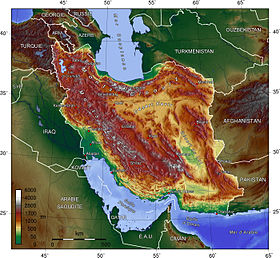 Zagros on the physical map of Iran | |
| Specifications | |
| Education period | Miocene |
| Square | 533 512 km² |
| Length | 1,600 km |
| Width | 300 km |
| Highest point | |
| Highest peak | Zerdkukh |
| Highest point | 4548 [1] m |
| Location | |
| A country |
|


Geography
Zagros (Pers. Patak, Poshtekukh) is located in the southwestern part of the Iranian highlands stretching for a distance of more than 1,500 km from the province of Kurdistan at the border with Iraq to the Strait of Hormuz . The mountain range runs parallel to the Tigris and the Persian Gulf , from which they are 50-100 km away. The highest peak with a height of up to 4548 m (Zerdkuh city). located near the city of Isfahan , south of Shiraz . Zagros on average 1000 m below Zerdkuh.
Geology
Geologically , Zagros belongs to the young folded mountain systems that arose in the Miocene ( en: Zagros fold and thrust belt ), like the Pyrenees , Alps , Carpathians , Balkan Mountains and Elburz , and is included in the so-called Mediterranean folded belt . To the east, this mountain belt continues with the Hindu Kush , Karakoram and the Himalayas .
History
In Iraq, there is the Shanidar Cave, in which the remains of Neanderthals were discovered.
It is assumed that for the first time a man managed to tame goats in the Zagros mountains. In addition, the Zagros region is considered the birthplace of tribes such as the Gutia and Lullubey . In the Assyrian era, the kingdom of Namri was located here.
Strabo claimed that Zagros separated Media from Babylonia [2] .
Zagros High Altitude
Mountain desert landscapes prevail. In the middle belt of the western, most humid part of Zagros - forests and woodlands of oak, elm, maple, acacia, above - alpine meadows and low-growing shrubbery. Small glaciers. In the intermontane basins there are salt marshes, lakes and oases (date palm, citrus fruits, grapes).
See also
- Qum (river)
Notes
- ↑ Zagros // Big Russian Encyclopedia : [in 35 vols.] / Ch. ed. Yu.S. Osipov . - M .: Great Russian Encyclopedia, 2004—2017.
- ↑ Strabo . Geography . 11: 12: 4
Literature
- Zagros // Big Russian Encyclopedia : [in 35 vols.] / Ch. ed. Yu.S. Osipov . - M .: Great Russian Encyclopedia, 2004—2017.