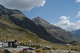
Julier [1] ( German: Julierpass ) - pass , located in the Rethian Alps , in the Swiss canton of Graubünden ; connects the Upper Halbstein Valley ( German Oberhalbstein ) and the Upper Engadine . The postal road, constructed in 1825 , goes from Tifenkastel to the south, past the villages of Savognin (Romanesque. Savognino ) and Mulegns (Romanesque. Molins), and reaches the Bivio (Italian. Bivio , 1776 m), where it branches to the right the path through the Septimer pass to Bregaglia ; then it turns east, reaches the height of a mountain passage (2,287 m) between the peaks of Gulya (3,385 m) and Polashin (3,017 m), from where it descends to Silvaplana . Julier Pass is one of the safest; already at the time of the Romans one of the main roads passed here.
| Julier | |
|---|---|
| him. Julierpass | |
 | |
| Characteristics | |
| Saddle Height | 2287 m |
| Location | |
| A country |
|
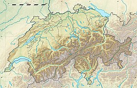
| Canton | Graubunden |
| Mountain system | Alps |

Notes
- ↑ Switzerland, Liechtenstein // Atlas of the World / comp. and preparation. to the ed. PKO "Cartography" in 2009; ch. ed. G.V. Pozdnyak . - M .: PKO "Cartography": Onyx, 2010. - S. 62. - ISBN 978-5-85120-295-7 (Cartography). - ISBN 978-5-488-02609-4 (Onyx).
Literature
- Julian Mountain Passage // Brockhaus and Efron Encyclopedic Dictionary : in 86 volumes (82 volumes and 4 additional). - SPb. , 1890-1907.