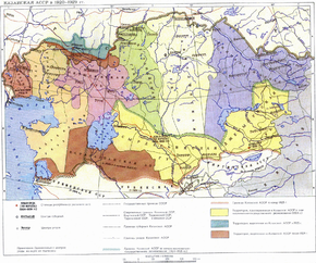
The Kara-Kalpak Autonomous Region is an administrative-territorial unit of the Kazak Autonomous Soviet Socialist Republic as part of the RSFSR in 1925-1929, and directly autonomous region directly subordinate to the RSFSR in 1930 - 1932 . The administrative center and largest city of Kara-Kalpak Autonomous Okrug was Turtkul . The second largest city was Nukus . According to the All-Union Census of 1926, the population of AO was 304 thousand people.
| Autonomous region | |||
| Kara-Kalpak Autonomous Region | |||
|---|---|---|---|
| Karakalp. قاراقالپاق موختار آبلسی kaz. قاراقالپاق موختار آبلسی Uzbek قاراقالپاق موختار ویلایاتی | |||
 | |||
| |||
| A country | |||
| Included in | |||
| Adm. Centre | Turtkul | ||
| History and Geography | |||
| Date of formation | February 16, 1925 | ||
| Date of Abolition | March 20, 1932 | ||
| Square | Miscellaneous during the existence of AO. From 124.0 thousand km² | ||
| The largest city | Turtkul | ||
| Dr. big cities | Nukus , Khojeyli | ||
| Population | |||
| Population | 304,500 people ( 1926 ) | ||
| Nationalities | Mostly Karakalpaks , Kazakhs and Uzbeks , also Turkmens , Russians and others | ||
| Denominations | mostly Muslims are Sunnis , also Christians | ||
| official languages | Karakalpak , Kazakh , Uzbek and Russian | ||
 | |||
History
The creation of the Kara-Kalpak Autonomous Region was preceded by the organization of the Kazakh-Karakalpak branch at the Khorezm Central Executive Committee. The Kazakh-Karakalpak branch was established in 1920 by the decision of the 1st Congress of Soviets of the Khorezm Republic in order to solve the common problems of the Kazakh and Karakalpak peoples. In October 1923, at the 3rd Congress of Soviets of the Khorezm Republic, a resolution was adopted on the formation of the Kazakh-Karakalpak Autonomous Okrug and the transformation of the city of Khojeyli into its center. In May 1924, the 4th Congress of Soviets of the Republic issued a decision on the formation of autonomy [1] .
The Kara-Kalpak Autonomous Region was formed on February 16, 1925 (actually in 1924) from the territory of the Amu Darya region of the Turkestan ASSR , as well as from part of the former Kyrgyz-Karakalpak Autonomous Region of the Khorezm Socialist Soviet Republic .
Before obtaining official status, it occupied only parts of the territories of the Turkestan ASSR and the Khorezm SSR . In 1929, part of the territory of the abolished Adaevsky district was included in the autonomous region. It was originally part of the Kyrgyz (since March 1925 it was called the Kazak Autonomous Soviet Socialist Republic ), and in 1930 it was transferred to the direct subordination of the RSFSR .
March 20, 1932 transformed into the Kara-Kalpak Autonomous Soviet Socialist Republic . December 5, 1936 transferred to the Uzbek SSR .
Population
The ethnic composition of the population of Kara-Kalpak Autonomous Okrug according to the All-Union Census of 1926 [2] .
| nationality | people | % |
|---|---|---|
| Total | 304539 | 100.00% |
| karakalpaki | 116125 | 38.13% |
| Kazakhs | 85782 | 28.17% |
| Uzbeks | 84099 | 27.62% |
| Turkmens | 9686 | 3.18% |
| Russians | 4924 | 1.62% |
| Tatars | 884 | 0.29% |
| Persians | 756 | 0.25% |
| Ukrainians | 621 | 0.20% |
| Arabs | 489 | 0.16% |
| Kyrgyz | 277 | 0.09% |
| Tajiks | 67 | 0.02% |
| the Jews | 62 | 0.02% |
| other | 767 | 0.25% |
Notes
- ↑ Kazakh-Karakalpak branch // Kazakhstan. National Encyclopedia . - Almaty: Kazakh encyclopedias , 2005. - T. III. - ISBN 9965-9746-4-0 .
- ↑ All-Union Population Census of 1926. The national composition of the population in the regions of the RSFSR (Kazak Autonomous Soviet Socialist Republic, Kara-Kalpak Autonomous Okrug) Demoscope