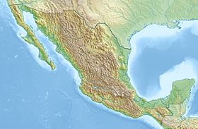
Southern Sierra Madre [1] [2] ( Spanish: Sierra Madre del Sur ) - an ancient mountain system in the south of Mexico , stretched for 1000 km along the Pacific coast - runs from the southern part of the state of Michoacan through Guerrero to the isthmus of Teuantepec in the east of the state Oaxaca .
| South sierra madre | |
|---|---|
| Spanish Sierra madre del sur | |
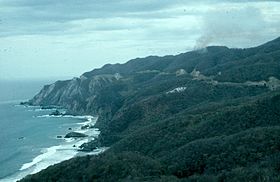 Southern Sierra Madre, Michoacan | |
| Specifications | |
| Square | |
| Length | |
| Highest point | |
| Highest peak | Teotepec |
| Highest point | 3703 m |
| Location | |
| A country |
|
In the north of Oaxaca, the southern Sierra Madre is connected to the Transmexican volcanic belt , but to the west they are separated by the valley of the Balsas River and its tributary Tepalkatepek.
The width of the ridge is up to 300 km. Despite the fact that only individual peaks exceed 3,000 m, the system is difficult to access and serves as a serious obstacle to transport links between the Pacific coast and the interior of the country. The highest point is Mount Teotepec (3,703 m) , located in the central part of the state of Guerrero ( ). The mountain peaks located in the southern part of Michoacán (in the area of the Municipality of Coalcoman ) are separated from the Southern Sierra Madre ridge by the deep canyon of the Balsas River, but, as a rule, are considered an integral part of the ridge.
The height of the Isthmus of Teuantepec is small (up to 650 m), so it serves as the border with the Sierra Madre de Chiapas mountain system, located in southeastern Mexico.
Content
Geology
The ridges of the Southern Sierra Madre system are mainly composed of metamorphic rocks with pre- Cambrian cores, places with neogenous lava covers, and Mesozoic sedimentary rocks are found in the internal depressions. In the north side of the ridge is the Las Truchas iron ore deposit. Extraction of silver , gold , antimony . There are no volcanoes in the system, but the area is considered seismic.
Ecology
Southern Sierra Madre is characterized by high biological diversity and a large number of endemic species. The upper part of the ridge is occupied by coniferous-leaved forests, below - tropical light forests, shrubs and summer-green forests. The southern slopes are used under tropical plantations.
Notes
- ↑ Mexico, Central America // Atlas of the World / comp. and preparation. to the ed. PKO "Cartography" in 2009; ch. ed. G.V. Pozdnyak . - M .: PKO "Cartography": Onyx, 2010. - S. 170—171. - ISBN 978-5-85120-295-7 (Cartography). - ISBN 978-5-488-02609-4 (Onyx).
- ↑ Southern Sierra Madre // Dictionary of geographical names of foreign countries / ed. ed. A.M. Komkov . - 3rd ed., Revised. and add. - M .: Nedra , 1986.- S. 453.
Links
- South Sierra Madre Forest Information (World Wildlife Fund)
- Sierra Madre South - article from the Great Soviet Encyclopedia .