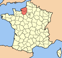
Upper Normandy ( French Haute-Normandie , Norman. Ĥâote-Normaundie ) - the former administrative region in the north of France , which included the departments of Seine-Maritime and Er . Since January 1, 2016 it is part of the Normandy region .
| Upper Normandy fr. Haute-normandie | ||
|---|---|---|
| ||
| A country | ||
| Status | former region | |
| Includes | Departments : Ayr (27) Seaside Seine (76) | |
| Administrative center | Rouen | |
| The largest city | Le Havre | |
| Council President | Nicola Mayer-Rossignolle (since 2013; joint venture ) | |
| Population ( 2011 ) | ▲ 1 839 393 (14th place) | |
| Density | 149 people / km² | |
| Square | 12317 km² | |
 | ||
 | ||
| Timezone | GMT + 1; in summer +2 | |
| ISO 3166-2 Code | FR-Q | |
| Official site | ||
The region was formed as part of the 1956 national administrative reform. The word “Upper” in the name of the region was used because it was located at higher geographical latitudes relative to the neighboring Lower Normandy region ; the absolute height above sea level is Upper Normandy lower than Lower Normandy .
Geography
The territory of the former region is 12,317 km². The region included departments of Ayr and Seine-Seine . The rivers Seine , Er , Völ flow through its territory.
The following natural areas are located in Upper Normandy:
- Pey de Caux ( French: Pays de Caux ) - land located between Rouen, Dieppe and Le Havre; fertile elevated plain with chalky soils, indented by river valleys and small hanging valleys overlooking the English Channel .
- Pays de Bray ( French: Pays de Bray )
- Seine Valley
- Marais Vernier ( fr. Marais Vernier ) - a small area with previously wetlands, where there was previously a bend of the Seine; the area is favorable for cattle breeding and is known for its thatched huts.
History
In 911, the Viking leader Rollon entered into an agreement with Carolingian King Charles III the Simple . Under the terms of this Saint-Clair-sur-Eptian treaty, the king entrusted Rollon with the defense of Rouen County , whose lands roughly corresponded to the territory of the modern region of Upper Normandy.
In the XVIII century, the slave trade reached its zenith. The townspeople of Le Havre , Rouen and Honfleur actively enjoyed the economic benefits associated with such triangular trade . Cotton processing began to develop in the cities, which served as the basis for the industrial revolution . The number of manufactories has grown; they are discovered in the suburbs of Rouen. However, these changes affected mainly the eastern part of Normandy (that is, the land of modern Upper Normandy).
In the process of establishing administrative regions in France in 1956, the five Norman departments were divided between two regions - Upper Normandy and Lower Normandy . Despite the fact that the borders remained intact, this demarcation again revived discussions about differences, the roots of which date back to the XVI and even to the XIV century [1] .
Economics
In Upper Normandy produced:
- 60% of the total national production of lubricants
- 50% of plastic production and 30% of wagons
Among all the French regions, Upper Normandy occupied:
- 4th place in terms of foreign economic activity
- 1st place for flax production
- 6th place in terms of research
Transport
The former Upper Normandy region is served by the TER Haute-Normandie TER suburban rail network. The network was formed around two radial highways of national scale - the line Paris - Le Havre and the line Paris - Caen . The central point of the network is the Rouen-Rive-Droite Rouen station, where most of the TER lines meet.
Culture
Upper Normandy ranked first in France in concentration of museums and second in concentration of theaters. Exceptional forests occupy about 20% of the territory of the former region. There are over 50 gardens and parks in Upper Normandy.
Regional gastronomy
Features of the regional cuisine of Normandy are due primarily to the geographical location of the region. Its fertile land provides an abundance of agricultural products, and the sea provides a generous catch of fish and a variety of shellfish.
However, dairy products set the tone in regional cuisine; Normans' love of butter and cream is almost legendary.
Notes
- ↑ Michel de Boüard. Histoire de la Normandie. - Toulouse: Privat, 1970 .-- P. 268-269.
Links
- Wikimedia Commons has media related to Upper Normandy
- Official site of the region
- Normandy Tourism