| Dusseldorf Altstadt | |
|---|---|
 |  |
| Height : | 38.0 m above sea level |
| Surface area : | 0.48 km² |
| Number of inhabitants: | 1 911 people (Comp. December 31, 2012) [1] |
| Population density : | 3 981 people on km² |
| City District : | District 01 |
| Urban area: | 011 |
| Entry into the city: | 1288 year |

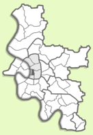
Altstadt ("Old Town"; German: Altstadt ) - the historical center of Dusseldorf . Many important sights are concentrated here and almost every street is known or famous for something. Altstadt is one of the 50 districts of Düsseldorf and belongs to district No. 1 . In the district (December 31, 2012) 1914 residents live, which with an area of 0.48 km² determines a high population density of 3,981 people. on km².
Altstadt is the historical, political and cultural center of the land capital. Here are the Düsseldorf Town Hall , the North Rhine – Westphalia Art Collection and the Düsseldorf Academy of Arts . Most of the Old Town is a pedestrian area with numerous cafes and other shopping establishments. Over an area of just 0.5 km², there are more than 300 beer pubs, discos and restaurants, which, as the old hymn says to dark beer Düsseldorf (Altbier), form the "longest bar counter in the world." With its “facade”, the Old Town faces the Rhine and its promenade ( promenade ) is considered to be one of the most beautiful along the entire river.
Altstadt is bounded by the Hofgarten in the northeast, passes into Carlstadt in the south, and merges with the Stadtmitte district in the southeast.
Content
- 1 History
- 2 Streets, squares and their attractions
- 2.1 Akademiestraße (Academy Street)
- 2.2 Andreasstraße (Andrei street)
- 2.3 Berger Straße (Berger Street)
- 2.4 Bolkerstraße (Bolke Street)
- 2.5 Burgplatz
- 2.6 Eiskellerberg
- 2.7 Eiskellerstraße
- 2.8 Flinger Straße
- 2.9 Heinrich-Heine-Allee
- 2.10 Marktplatz
- 2.11 Rathausufer
- 2.12 Schloßufer
- 2.13 Ursulinengasse
- 3 notes
- 4 Literature
History
Modern Düsseldorf grew out of the Old Town, although older districts can also be found in its vast urban area. For the first time, the village (village) “Düsseldorp” (Düsseldorp) was first mentioned in documents in 1159 [2] . The following document (presumably before 1190 ) reports that the knight Arnold von Tyvern pledges all his right-bank Rhine possessions to Count Engelbert von Berg for 100 silver marks. In the list of these settlements are Dusseldorp and Hummelgiz (Hummelgis, now Himmelgeist , Himmelgeist) [3] . Subsequently, the pledge was not redeemed and Dusseldorp became the property of the Counts of Berg. Already in the middle of the XIII century, the village had a certain economic significance in connection with its crossing the Rhine on the trade route. On August 14, 1288 , after the Battle of Vorringen , Düsseldorp acquired city status and received city privileges corresponding to this status.
In the year of obtaining the status of a city in Dusseldorf, there were only a few streets, or rather, only one Alteshtadt street and several lanes. Along with Deliveries Lane (Liefergasse, Liefergasse), Lion Lane (originally called Levengasse), later changed its name to Löwengasse [4] . There were two more lanes (now their names are lost) located on the site of modern Lambert Street (Lambertus-Strasse, Lambertusstraße) and Müller-Schlösser-Gasse Lane. Another street may have already existed, as the old building shows an empty space between the shaft (wall ?) and the built-up territory on the site of modern Bargaining new street (Kremer Strasse, Krämerstraße) .In any case, only its eastern side could be built up in 1288. It stretched from the South Gate of the city (Südtor, Südtor), on the site of which Castle Gate was subsequently built (Burg- torr, Burgtor), to the beginning of Alteshtadt [2] [5] . On this street, a small door was made in the city wall that opened to the Rhine, called Lindenrappenpforte and later renamed Coal Gate (Kolen tor , Kohlentor) [6] [7] . Most likely the second real street really existed, since it is difficult to imagine a city fortification with only one gate.
The small town was well protected on three sides: from the east by the Rhine river, from the south by the Düssel river and from the north by the sleeve of the Old Rhine. Only in the east did they have to create an artificial defense in the form of an earthen rampart, probably reinforced with wooden structures [8] . The total area within the city wall was approximately 3.8 ha with a wall length of about 800 m [9] . According to experts, in 1300, from 300 to 400 people lived in the city and only two stone houses were built [10] .
Streets, squares and their sights
Akademiestraße (Academy Street)
The street got its modern name, most likely, in 1782 , since it was from this year that the Academy of Arts ( 1810 ) was located here. The Academy in Dusseldorf was founded a little earlier, in 1762 and officially approved by Elector Karl Theodor in 1777 .
The street in the very first documents was called "eighth against the wall" (meaning the fortress wall of the first fortified settlement). In 1710, it was renamed Komissariattstrasse, because here Matteo Alberti, the then chief construction director at the Elector, John Wilhelm, built the building of the mountain general military commissariat. Then on the street they built the Hontheim Palace. Both buildings overlooked the then harbor of Düsseldorf with their backyards and joined together. Later, the Academy of Arts was located here and the street was called the “Academy Street”. Unfortunately, the Academy building did not survive, as it was destroyed during the Second World War.
The new building of 1992 on the western (odd) side of the street essentially corresponds to the old line of building facades. Currently, the street is paved with cobblestones and has one-way traffic (from the Rhine ).
Under house number 1 is an underground four-story car parking. You can get here from the underground motorway running along the Rhine near Alstadt. The depth of the first floor is below the water level in the river. Here, nearby, at the entrance to the street (from the side of the old harbor) there is a sculptural monument to a Jewish girl who died in a Nazi concentration camp .
In the house number 3 exhibited works of various types of fine art under the general name "Gallery for Art Nouveau and Contemporary Art ." Its owner is Karl Heinz Röhrich.
| Academy Street | Street view from the Rhine | West (odd) side of the street | Collectors Store | |||
|---|---|---|---|---|---|---|
The strict beautiful old building No. 4 is completely occupied by the structures of one of the main institutions of the city hall (Hauptamt). Entrance into it is possible only through building No. 2.
The bakery of house number 8 was founded Aug. Buschmann in 1846 . It still works and is currently owned by Andreas Buschmann.
On the ground floor of house number 20, there is a well-known in the city small shop of original Düsseldorf mustard . Its most famous varieties are Düsseldorfes Radschläger Senf, 1726 ABB and Original LöWensenf.
| Academy Street | House number 6. Beer bar | House number 8. Bakery | House number 18. Spanish restaurant | |||
|---|---|---|---|---|---|---|
Andreasstraße (Andrew Street)
Located between Mertensgasse and Hunrückenstraße. It originates from the first expansion of Düsseldorf in 1384. It got its modern name during the construction of the Catholic Church of St. up Andrei (1629).
Berger Straße (Berger Street)
Located between Rheinstraße and Karlplatz. Named in 1478. It arose during the expansion of the city in 1384.
Bolkerstraße (Bolke Street)
Located between Marktplatz square and the Heinrich-Heine-Allee mall . First mentioned under the year 1417. The street was formed as a result of the expansion of the city in 1384 and retained the name of its first inhabitants: Henneken Bolke (Henneken Bolke, 1398) and John Bolke (Johan Bolke, 1408). Over time, the street became one of the most important shopping in Dusseldorf. In recent decades, there are more and more gastronomic and beer establishments, so Bolke Street is considered one of the main components of the so-called "longest beer counter in Europe", which is Dusseldorf.
Burgplatz
Extends from the Schloßufer seafront to Bolkerstraße. Its name is historical. At this place was the first fortress of Dusseldorf, in which was the residence of the Counts von Berg (Grafen von Berg). Later, the fortress was used by the dukes and electors. The catastrophically violent fire of 1872 destroyed most of the buildings. From those days there was only a castle tower (Schloßturm), which is currently one of the symbols of Düsseldorf. During World War II, buildings bordering the area from the east were destroyed. The square acquired a modern look in 1994-95, after major restoration work.
Eiskellerberg
Located between Eiskellerstraße and Mühlengasse Lane.
Eiskellerstraße
Located between Fritz-Roeber-Straße and Reuterkaserne. The name comes from the cellars of the once-located bastion of Elisabeth Augusta, in which there was a glacier of the princely court.
Flinger Straße
Located between Berger Straße and the Heinrich-Heine-Allee.
Heinrich-Heine-Allee
Marktplatz
Rathausufer
Schloßufer
Ursulinengasse
Notes
- ↑ Altstadt statistics for December 31, 2012
- ↑ 1 2 Düsseldorfer Geschichtsverein: Festschrift zum 600jährigen Jubileum. 1888, p. [371] 354 ( Electronic version of the Dusseldorf Library )
- ↑ Wilhelmi JF: Panorama von Düsseldorf. 1828, p. [17] ( Electronic version of the Dusseldorf Library )
- ↑ H. Ferber : Historische Wanderung durch die alte Stadt Düsseldorf. Herausgegeben vom Düsseldorfer Geschichtsverein; Verlag C. Kraus, 1889, Teil I, p. 49.
- ↑ Hugo Weidenhaupt: Düsseldorf, Geschichte von den Ursprüngen bis ins 20. Jahrhundert , 1988, Verlag Schwann / Patmos, Band 1, p. 181, ISBN 3-491-34221-X .
- ↑ H. Ferber: Historische Wanderung durch die alte Stadt Düsseldorf. 1889, Verlag C. Kraus, Teil I, p. 61
- ↑ In: Stadtarchiv Düsseldorf , Geschichtendatei, Band QS, p. 27.
- ↑ Internetportal: Geschichte in Düsseldorf.
- ↑ Hugo Weidenhaupt : Kleine Geschichte der Stadt Düsseldorf. 9th ed. Triltsch, Dusseldorf, 1983, p. 30.
- ↑ Der Düsseldorf Atlas. Emons Publishing House, Cologne, 2004, ISBN 3-89705-355-1 , p. 26.
Literature
- Der Atlas 3 am Rhein (Krefeld, Düsseldorf, Neuss), Mb 1:20 000, 2006
- Die Düsseldorfer Altstadt. Theo Lücker. Verlag der Goethe-Buchhandlung, Düsseldorf, 1 und 2 Bände, 1985
- Düsseldorf. Sonja Schürmann. DuMont Buchverlag Köln, 1988
- Hermann Kleinfeld. Düsseldorfs Straßen und ihre Benennung, Grupello Verlag, 1996
- Jörg Heimeshoff. Denkmalgeschützte Häuser in Düsseldorf. Nobel, 2001.
- Karl H. Neidhöfer. Düsseldorf. Srtraßennamen und ihre Geschichte. Droste Verlag, 1979.
- Sr. GM Amian. St. Josefkapelle in der Düsseldorfer Altstadt. Prospect guide for the chapel of St. Joseph in Altstadt Dusseldorf. Edition of the Daughters of the Holy Cross, 2008. Yaz. him.
- Steine sprechen. Kleiner Wegweiser durch die Düsseldorfer Altstadt. Theo Lücker. Düsseldorf, 1977