Armenian highlands
| Armenian highlands | |
|---|---|
 | |
| Specifications | |
| Square | 400,000 km² |
| Highest point | |
| Highest peak | Ararat |
| Highest point | 5165 m |
| Location | |
| Country |
|

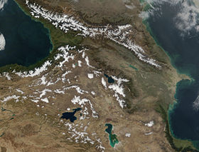
Armenian Highlands [1] [2] [3] ( armenian Հայկական լեռնաշխարհ [Haykakan leṙnašxarh]) is a mountainous region in the north of Western Asia [4] . The average of the three Asian uplands . In the west, without sharp boundaries, it passes into the Asia Minor Plateau , in the east it adjoins the Iranian Plateau .
Content
Title
The Armenian Highlands got its name due to the fact that within the highlands there was a historical area of the formation of the Armenian people [5] .
Location
Most of the Armenian Highlands are located within modern Turkey and Armenia . The north-western part of Iran , the south of Georgia and the western part of Azerbaijan also belong to the Armenian plateau [4] . In the broad sense of the word, the Armenian Highlands include the Lesser Caucasus , the Eastern (Armenian) Taurus and the Kurdish Mountains [6] . It comprises the Javakheti, Kara, Geghama, Vardenis and Karabakh (Syunik) uplands, and the Agdag massif in the south [7] .
The highland consists of two climatic zones.
- Inland - Armenian plateau, covered with mountain-steppe and semi-desert landscape with a dry sharply continental climate.
- The outer zone is the Armenian Alps, consisting of the East Pontic Mountains , the East (Armenian) Taurus Mountains and the Lesser Caucasus Mountains, bordering the plateau on three sides, where its northern, southern and eastern spurs are characterized by a mild, humid, seaside or Mediterranean climate, with a massive or even full forest cover. [8] .
The central, axial chain of highland ridges passing from west to east through the whole of Western Armenia is called Anti-Taurus [9] [10] . In the west, the Anti-Taurus goes north from the Central Taurus , and, passing directly in the middle of the plateau, parallel to the Eastern Taurus , ends in the east with Ararat peaks.
In the west, the Armenian Highlands merges with the Asia Minor Plateau, in the south at its foot is the Mesopotamian Lowland , and in the southeast it gradually merges with the Iranian Highlands .
In the north-west, the Armenian Highlands are separated from the Caucasus Mountains by the Colchis Lowland , and in the north-east of the Kura-Araksinsky , connecting with them in the center by the Likh Range . The area of the Armenian Highlands (in the broad sense) is about 400 thousand km². [6]
Building
The Armenian plateau is a powerful mountain junction in which the northern and southern marginal chains of the Asia Minor and Iranian uplands merge, forming a complex system of ridges and troughs. At the end of the Neogene, the entire highland underwent splitting and was intersected by a system of cracks along which outflows of lavas occurred. Lavas covered almost the entire surface of the plateau with basalt strata, mainly smoothing out uneven terrain.
Currently, the Armenian Highlands are vast basalt-tuff plateaus (1,500-3,000 m high) with giant volcanic cones (formed in the later stages of volcanic activity and reaching several thousand meters high) and tectonic depressions separated by ridges. Depressions lying at altitudes from 700 to 2000 meters have dry bottoms or are occupied by lakes ( Van , Sevan , Urmia and others). They are centers of population and are often referred to by the cities located within them - Erzurum , Tabriz , Ararat , Mush and so on.
Top Peaks
In total, on the Armenian Highlands there are 4 mountains with a height of 4,000 to 5,000 meters and 1 mountain with a height of over 5,000 meters.
Some famous peaks:
- Greater Ararat (5165 m) [11]
- Sebelan (4811 m) [11]
- Cilo (4168 m) [11]
- Aragats (4090 m) [11]
- Sipan (Syuphan) (4058 m) [11]
- Kachkar (3937 m)
- Small Ararat (3925 m) [12]
- Kaputjuh (3905 m) [13]
- Gazanasar (3841 m) [13]
- Siskatar (Sisakapar) (3826 m) [13]
- Paracan (3825 m) [13]
- Kapuyt (a separate peak on Paracan) (3751 m) [13]
- Gomshasar (Gyamysh) (3724 m) [13] [14]
- Sehend (3707 m)
- Alun (a separate peak on Paracan) (3703 m) [13]
- Azhdahak (3597 m) [13]
- Spitakasar (3560 m)
- Metz Ishkhanasar (3550 m) [13]
- Mrav (3340 m)
- Koshaty (3317 m)
- Abul (3300 m)
- Nemrut (2948 m).
I. Aivazovsky , Descent of Noah from Mount Ararat , 1889
volcano Nemrut Dag
Mount Mrav
Areni Caves
mountain ranges in Dilijan
Pushkin Pass
Syunik mountains
Volcano Sevkatar
Rock Gavazan
Rivers and Lakes
The water network of the region belongs to the basins of the Caspian and Black Seas, the Persian Gulf . Within the highlands are the upper reaches of the Kura , Araks , Euphrates , Tigris , Chorokh rivers . The nature of the current is typical of the mountain. The origins are mainly in the mountains, and the food comes from melting snow and rainfall.
The largest rivers of the Armenian Highlands are:
- Euphrates (2736 km)
- Tiger (1850 km)
- Kura (1515 km)
- Araks (1072 km)
- Aratsani (722 km)
- Big Zab (473 km)
- Chorokh (438 km)
- Akhuryan (186 km)
- Debed (152 km)
- Hrazdan (141 km)
- Arpa (126 km)
- Vorotan (119 km)
In total, there are over 95,000 large and small rivers in the Armenian Highlands, of which over 4,000 are more than 10 kilometers long.
Akhuryan
Kura
Arax
Sarsang reservoir
Big Zab
Agstev
Azat River, the upper reaches of which are included in the UNESCO World Heritage List
Chorokh
waterfall in berkri
Jermuk Waterfall
Kasahsky waterfall
Shaki waterfall
| Lake | Picture | Square | Deepest | Average depth | Height above sea level | Information |
|---|---|---|---|---|---|---|
| Van | View of Lake Van from Akhtamar Island | 3574 km² | 451 m | 161 m | 1648 m | The world's largest soda lake. The width of the lake is 119 km. There are three islands on the lake: Akhtamar , Ktuts and Lim. All three islands over the past thousand years, until 1915, were the abode of Armenian monasticism, and the island of Akhtamar was the center of one of the Catholicosates of the Armenian Apostolic Church . |
| Sevan | View of Lake Sevan | 1243 km² | 80 m | 27 m | 1896 m | Fresh lake with drinking water. Up to 2,000 tons of fish are caught here annually. The lake is 78 km long and 56 km wide. |
| Urmia | lake Urmia | 5200 km² | 16 m | 5 m | 1275 m | The largest lake in the Middle East. One of the most saline lakes in the world. There are 105 islands on the lake. The lake is 140 km long and up to 55 km wide. To date, the lake is on the verge of extinction. Due to the drought that began in 1998, the excessive consumption of water from the lake by residents of nearby cities and villages, as well as the construction of dams on the rivers that feed it, the area of Urmia was more than halved or, if counted from 1995, it became shallow more than by 70%. [15] |
| Tsovak Yusis | 115 km² | 42 m | 1959 m | The name of the lake is translated from Armenian as “Northern Lake” | ||
| Ercek | Ercek Lake | 95.2 km² | 30 m | 1890 m | Salt Lake. Length - 14 km, width - 9 km | |
| Hazard | 86 km² | 15 m | ||||
| Nazik | Nazik lake | 44.5 km² | 50 m | 1876 m | Fresh Lake. Length - 12 km, width - 7 km | |
| Parvana | Parvana Lich Lake | 37.5 km² | 3m | 2073 m | ||
| Balyk | 34 km² | 30 m | ||||
| Khozapin | Khozapin Lake | 27 km² | 10 m | 1798 m | ||
| Arpi | Arpi Lake | 22 km² | 2023 m | More than 100 species of birds live in the lake area. Some of them are included in the Red Book . | ||
| Hach | 16 km² | 25 m | ||||
| Tabatskuri | Tabatskuri Lake | 14.2 km² | 40 m | 1991 m | ||
| Nemrut | Lake Nemrut | 12 km² | 176 m | 2247 m | Located in the crater of an active volcano |
Other. In total, there are over 1200 large and small lakes in the Armenian Highlands.
Flora and Fauna of the Armenian Highlands
The Armenian Highlands occupies one of the first places in the world in the number of plant species per unit area - over 100 species per 1 km². [sixteen]
About 3,500 plant species from 150 families grow on the Armenian Highlands, of which about 108 species are found only in the Armenian Highlands .
The flora of the Armenian Highlands includes 4 taxonomic groups - algae , mushrooms , lichens and vascular plants .
The Armenian Highlands are distinguished by the species diversity and endemicity of their fauna, where about 17,500 species of vertebrates and invertebrates are found. Many animal species live on the border of their distribution zone or form separate populations.
| Group | Total number of species | Number of endemic species or subspecies |
|---|---|---|
| Vascular plants | 3555 | 106 |
| Mushrooms | 4166 | 2 |
| Mosses | 395 | - |
| Seaweed | 388 | - |
| Lichens | 300 | - |
| Invertebrates | 17000 | 316 |
| Fish | thirty | 9 |
| Mammals | 83 | 6 |
| Reptiles | 53 | 6 |
| Amphibian | eight | one |
| Birds | 349 | one |
Soils and vegetation
Currently, most of the Armenian Highlands is deprived of forests, although in ancient times the area was rich in forests, partially preserved only in the Pontic Mountains, on the Eastern (Armenian) Taurus Mountains, in the Lesser Caucasus Mountains and in the Kurdish (Kurdistan) Mountains. Flat basins are covered with steppe or semi-desert vegetation. Along the rivers you can meet flood meadows and bushes. At the foot of the mountains bordering the basins, oases are located in which cotton , tobacco and other crops are grown. In the Srednearaksinsky depression near Yerevan , on the territory of the Erebuni reserve , areas of the growth of wild wheat and other wild relatives of cultivated plants are preserved. Forests with a predominance of pine and deciduous oak are characteristic of humidified windward mountain slopes at heights of up to 2000 m. Above them, thorny shrubs and juniper thickets alternate with stony exposed areas. On dry soils and salt marshes, dry subtropical woodlands from pistachios , skeleton , hold-tree, and other xerophytes are found [17] .
History
The Armenian Highlands have been inhabited since time immemorial. There is a version that it was here that iron melting technology was invented ( Metsamor , Chatal-Hyuk and others) and horse breeding [18] [19] [20] . According to some scholars (mainly T. Gamkrelidze , V. Ivanov , O. Shirokov and others), it is the Armenian Highlands and Asia Minor that are the birthplace of the Indo-European peoples (see: The Armenian Hypothesis ), and it was here that the process of separation of the Indo-European peoples from the general families [21] [22] [23] [24] [25] [26] . In the light of archaeological data and modern paleogenetics, the Armenian hypothesis has outlived itself in the light of evidence, and horse breeding was invented in the Eurasian steppes from Bashkortostan to Mongolia. The military-strategic and commercial significance of the Armenian Highlands was one of the important reasons for many wars between the powers of the Mediterranean and Western Asia, starting from the Roman era. The arena of these wars usually became Armenia and neighboring countries. The Mesopotamian Plain south of Armenia was the hub of the main highways of trade exchange between East and West; it connected the Steppe Route with a passage through Derbent and Caucasian Albania (Agvank) along the coast of the Black and Caspian Seas [27] .
Historical states and state formations in the region
Created on the Armenian Highlands
| State | Period of existence |
|---|---|
| Aratta | XXVII — XXII centuries BC e. |
| Armanum | XXII — XVIII centuries BC e. |
| Armatana | XVII — XVI centuries BC e. |
| Hayasa | XV — XIII centuries BC e. |
| Nairi | XIII-IX centuries. BC e. |
| Urartu | 850s — 580s BC e. |
| Kingdom of ararat | 323-200 years. BC e. |
| Lesser Armenia | 323-115 BC e. |
| Sofena | III century — 94 BC e. |
| Great Armenia | 189 c. BC e. - 428 century n e. |
| Marzpanian Armenia | 428-645 |
| Armenian kingdom | 885-1045 |
| Vaspurakan kingdom | 908-1021 |
| Kars kingdom | 963-1064 |
| Tashir-Dzoraget kingdom | 978-1118 |
| Syunik kingdom | 987-1170 |
| Principality of Khachen | X-XVI centuries. |
| Efrates | end of the 11th century — 1117 |
| Principality of Edessa | 1083-1098 |
| Principality of Melitene | 1071-1104 |
| Principality of Pir | 1086 / 1097-1098 / 1100 |
| Shah Armen | 1100-1207 |
| Zakarid Armenia | 1199-1236 |
| Hams | 1603-1750s |
| Erivan Khanate | 1747-1828 |
| Nakhchivan Khanate | 1747-1828 |
| First Republic of Armenia | 1918-1920 |
| Socialist Soviet Republic of Armenia | 1920-1922 |
| Armenian Soviet Socialist Republic | 1936-1990 |
| Republic of Armenia (as part of the USSR) | 1990-1991 |
| Republic of Armenia (independent) | 1991 — present |
Partially Embracing the Armenian Highlands
| State | Period of existence |
|---|---|
| Armenian emirate | VII – IX centuries |
| Turkoman Kara-Koyunlu and Ak-Koyunlu | 1375-1501 |
| Safavid state , Afshars , Qajar Iran | 1501—1979 years |
| Ottoman Empire (In Western Armenia ) | XVI century -1922 year |
| Russian Empire (In Eastern Armenia , also see Eastern Armenia as part of the Republic of Ingushetia ) | beginning of XIX century - 1917 |
| Transcaucasian Soviet Federated Socialist Republic | 1922-1936 |
Notes
- ↑ Armenian Highlands // Dictionary of Geographic Names of Foreign Countries / Res. ed. A.M. Komkov . - 3rd ed., Revised. and add. - M .: Nedra , 1986.- S. 26.
- ↑ Armenian Highlands // Dictionary of Geographical Names of the USSR / GUGK , TsNIIGAiK . - 2nd ed., Revised. and add. - M .: Nedra , 1983.- S. 17.
- ↑ Instruction for the Russian transfer of geographical names of the Armenian SSR. - M., 1974. - S. 11.
- ↑ 1 2 Armenian Highland . - article from Encyclopædia Britannica Online . Date of treatment February 13, 2019.
- ↑ Pospelov E. M. / Armenian Highlands / Geographical Names of the World: Toponymic Dictionary. - M: AST. 2001.Original text (Russian)Armenian highlands. Turkey, Armenia, Iran. The name is due to the fact that within the highlands there was a historical area of the formation of the Armenian people.
- ↑ 1 2 Armenian Highlands // Great Soviet Encyclopedia : [in 30 vol.] / Ch. ed. A.M. Prokhorov . - 3rd ed. - M .: Soviet Encyclopedia, 1969-1978.
- ↑ Armenian Highlands / Geography. Modern illustrated encyclopedia. - M.: Rosman. Edited by prof. A.P. Gorkin. 2006. Page 42 (624) ISBN 5-353-02443-5 , 9785353024439 Original text (Russian)in Asia Minor within Armenia, Georgia, Azerbaijan, Turkey and Iran. It is bordered by high ridges: in the north - Pontic, in the north-east - an arch of external hr. Lesser Caucasus, in the south - Taurus. In the west and east it passes into the highlands of Turkey and Iran. The total area of about 400 thousand km². Belongs to the Alpine-Himalayan mountain belt. Pliocene-Quaternary lavas, basalts, andesites, and other volcanic rocks are widely developed. Deposits of barite, chromium, copper, halite, etc. Highlands are distinguished: Javakheti, Kara, Gegham, Vardenis, Karabakh (Syunik), in the south - the Agdag massif. The relief is generally mild and in some places even. Average altitudes are 1,500–2,000 m. Volcanic massifs, domes, and cones rise above the plateau. River valleys in the form of canyons with steep rocky slopes are deeply cut into lava plateaus. Lakes are often laden with lava flows (Sevan, Van). The most significant in height. extinct volcanoes Big Ararat (5122 m), Aragats (4090 m), Sebelan (4811 m), Syuphan (4053 m), Small Ararat (3896 m). Activity remained Tenderyuk volcano (3542 m). Volcano Nemrut (2935 m) is in the post-volcanic solfatar stage. High seismic activity. Modern glaciers on the peaks of Greater Ararat, Aragats. The climate is sharply continental. Summer is dry, average temperature is about +18 ° C, winter is cold (from –6 to –12 ° C), and rainfall is 450–600 mm per year. Large rivers: Euphrates, Chorokh, Araks, Kura; many lakes. In the basins there are steppes and semi-deserts, on mountain slopes up to 1400 m there are steppes and undersized, spiny, cushion-shaped shrubs, above are shiblyak-type thickets, juniper woodlands; in wetter areas - oak-pine woodlands. From high 2000 m - meadows, on the peaks - rocks with lichens. Nat Sevan park, reserves Dilijan and Khosrovsky.
- ↑ [1]
- ↑ [2]
- ↑ [3]
- ↑ 1 2 3 4 5 armeniangeographic. The highest peaks of the Armenian Highlands - ArmGeo (Russian) (neopr.) ? . Armenian Geographic - ArmGeo.am (February 13, 2017). Date of appeal April 27, 2019.
- ↑ Sputnik. The Russian astronaut showed Mount Ararat from orbit . ru.armeniasputnik.am. Date of appeal April 27, 2019.
- ↑ 1 2 3 4 5 6 7 8 9 vahemart. The highest mountains of Armenia . Vahe Martirosyan's blog (January 24, 2014). Date of appeal April 27, 2019.
- ↑ vahemart. Monument of nature "Mount Gomshasar" . Vahe Martirosyan's blog (December 3, 2013). Date of appeal April 27, 2019.
- ↑ Lake Urmia in Iran can save water from the Caspian
- ↑ UNECE Homepage
- ↑ EURASIA: MEDITERRANEAN AND THE FOREST ASIAN Highlands.
- ↑ Leslie Aitcheson. A History of Metals. Vol. I, II, 1960
- ↑ David M. Lang. Armenia: Cradle of Civilization. London: George Allen & Unwin, 1970. 50-1, 58-59.
- ↑ Hovick Nersessian. Highlands of Armenia. Los Angeles, 1998
- ↑ Thomas V. Gamkrelidze and VV Ivanov. The Early History of Indo-European Languages. Scientific American, March 1990, p. 110
- ↑ J. Schmidth. Die Urheimat der Indogermanen und das europaische Zahlensystem. Weimar, 1890
- ↑ V. Ilic-Svitich. Problems of Indo-European Linguistics, M., 1964. S. 3-12
- ↑ V. Georgiev. Questions of Linguistics, 1975, No. 5. P. 9
- ↑ E. Masson. Recherches sur les anciens emprunte semitiques en grec. Paris, 1967
- ↑ J. Mellart. The End of the Early Bronze Age in Anatolia and the Aegean - AJA, 1958, v. 62, No. 1 // Balkan Linguistic Collection. M. , 1977.S. 6
- ↑ History of.ru. World, world history - The oldest tribes, nationalities and states of the Armenian Highlands
See also
- Armenia (historical region)
- Geography of Armenia
- Geography of turkey
- Geography of georgia
- Geography of iran
- Geography of Azerbaijan