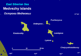
Bear Islands ( Yakut. Eһeleeh aryılar ) - a group of 6 islands in the Arctic Ocean . They are part of Yakutia . Located in the East Siberian Sea , north of the mouth of the Kolyma River . The total area of the islands is about 60 km².
| Bear Islands | |
|---|---|
 | |
| Specifications | |
| Number of islands | 6 |
| total area | 60 km² |
| Highest point | 273 m |
| Population | 0 pax (2010) |
| Location | |
| Water area | East-Siberian Sea |
| A country |
|
Consist of six islands: Krestovsky , Leontyev , Chetyrekhstolbovoy , Pushkaryov , Lysov and Andreev , They are composed of granites , shales.
Krestovsky Island is the largest in area, there are two mountains on it. The northern and eastern shores are steep and rocky, the western shore is low, covered with boulders and rubble, the southern shore is sloping, the only stream on the island flows there.
Mosses, reindeer mosses and hard, short grass grow on the island. In the northwest there is a flowing forest (fin), consisting of larch , fir and poplar . Wild deer are found from animals; many mice ; Bears , wolves and foxes come from the mainland.
The first time the Bear Islands was visited in 1710 by the Cossack Yakov Permyakov , sailing along the Arctic Sea from Lena to Kolyma . In 1740, Dmitry Laptev reached the Krestovsky Island, sailing from the Indigirka River to Kolyma. He called it the island of St. Anthony. Sergeant Stepan Andreev in March - April 1763 traveled around the Bear Islands with dogs and gave a cursory description of them. In 1769, the warrant officers of geodesy, Ivan Leontyev, Ivan Lysov and Alexei Pushkaryov, on dog sleds, walked along the ice from Nizhnekolymsk to the Bear Islands and made a fairly accurate map of them. [1] In 1761, Shelaurov’s expedition, on the way to Kolyma, hid from the ice between the Bear Islands. In 1821, the islands were visited by Lieutenant F. Wrangel . In April 1870, the islands were visited by the Neumann expedition. In the mid-1980s, an air expedition from the Wrangel Island Nature Reserve worked on the islands to search for the polar bear's den.
Climate
| Climate of the Bear Islands | |||||||||||||
|---|---|---|---|---|---|---|---|---|---|---|---|---|---|
| Indicator | Jan | Feb | March | Apr | May | June | July | Aug | Sep | Oct | Nov | Dec | Year |
| Absolute maximum, ° C | −7.8 | −6.7 | −6.1 | 3.9 | 10.0 | 17.8 | 21.7 | 18.3 | 10.0 | 7.8 | 0,0 | −2.2 | 21.7 |
| Average maximum, ° C | −25.6 | −26.7 | −23.9 | −16.7 | −5 | 2.2 | 4.4 | 3.9 | 0.6 | −7.8 | −17.8 | −24.4 | −11.7 |
| Average temperature, ° C | −27.2 | −28.3 | −25.6 | −18.3 | −7.2 | 0.6 | 2,8 | 2.2 | −0.6 | −8.9 | −19.4 | −26.1 | −13.3 |
| Average minimum ° C | −30.6 | −31.1 | −28.3 | −21.7 | −9.4 | −1.1 | 1,1 | 1,1 | −1.7 | −11.1 | −22.2 | −28.9 | −15.6 |
| Absolute minimum, ° C | −43.9 | −46.1 | −41.1 | −36.1 | −23.3 | −11.1 | −7.2 | −4.4 | −10 | −27.2 | −37.8 | −42.2 | −46.1 |
| Precipitation rate, mm | 3 | 3 | 3 | 3 | five | 13 | 20 | 20 | 13 | eight | 3 | five | 97 |
| Source: weatherbase | |||||||||||||
Notes
- ↑ Magidovich V.I., Magidovich I.P. Essays on the history of geographical discoveries. T. 3.M., 1984.
Topographic maps
- Map sheet R-57-XI, XII Bear Islands . Scale: 1: 200 000. Status of the area for 1955.
- Map sheet R-58-VII, VIII .
- Map sheet R-57-XVII, XVIII m. Krestovsky . Scale: 1: 200 000. Status of the area for 1954.
- Map sheet R-58-XIII, XIV .
Links
- Bear Islands // Brockhaus and Efron Encyclopedic Dictionary : in 86 volumes (82 volumes and 4 additional). - SPb. , 1890-1907.
