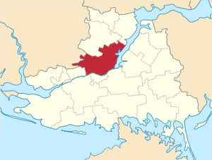
Berislavsky district ( Ukrainian: Berislavsky district ) - the administrative unit of the Kherson region of Ukraine . The administrative center is the city of Berislav .
| area | |||||
| Berislavsky district | |||||
|---|---|---|---|---|---|
| Berislavsky district | |||||
| |||||
| A country | Ukraine | ||||
| Included in | Kherson region | ||||
| Includes | 1 city council 1 village council 21 village council | ||||
| Adm. Centre | Berislav | ||||
| History and Geography | |||||
| Date of formation | 1938 | ||||
| Square | 1.7 thousand km² | ||||
| Timezone | EET ( UTC + 2 , summer UTC + 3 ) | ||||
| Population | |||||
| Population | 45 533 [1] people ( 2017 ) | ||||
| Official language | Ukrainian | ||||
| Digital identifiers | |||||
| Telephone code | +380 5546 | ||||
| Postal codes | 74306 | ||||
| Auto Code numbers | VT | ||||
 | |||||
 | |||||
![Flag [d]](http://upload.wikimedia.org/wikipedia/commons/thumb/0/03/Beryslavskiy_rayon_prapor.png/160px-Beryslavskiy_rayon_prapor.png)
![Coat of arms [d]](http://upload.wikimedia.org/wikipedia/commons/thumb/6/6f/Beryslavskiy_rayon_gerb.png/90px-Beryslavskiy_rayon_gerb.png)
Content
Geography
The Berislavsky district is located in the central part of the Kherson region, in the Black Sea lowland , on the right bank of the Dnieper and the Kakhovka reservoir . It covers an area of 172.0 thousand ha.
In the north it borders on the Novovorontsov district , in the east - on the Velykolepetikh , Gornostaevsky and Kakhovsky regions, in the south - on the city of Novaya Kakhovka , Alyoshkovsky and Belozersky districts, in the west - on the Snigirevsky district of the Nikolaev region and Velikoaleksandrovsky district of the Kherson region.
Population
The population of the district is about 56 thousand people. Of these, 20 thousand people live in Berislav, 36 thousand people in the rural area. There are representatives of 60 nationalities in the region. The places of compact residence of national minorities are the village of Zmievka ( Germans , Swedes ) and the village of Cossack ( Assyrians ).
History
In the III-IV century, the district was the capital of the Ostrogothic kingdom Danparstadt, at the end of the XIV century - the residence of the Golden Horde khan Tokhtamysh - Dogangechit. In 1484, the Turks built the Gazi-Kermen fortress here (later Kyzy-Kermen ). During the first Azov campaign of Peter I in 1695, the fortress was destroyed by Cossack regiments of the hetman Mazepa .
In 1784, the city of Berislav was founded on the ruins of Kizi-Kermen.
The district has over 350 different attractions, including:
- The remains of the Kamensky Sich in the village of Republican
- The grave of the ataman Kostya Gordienko
- Memorial sign in honor of the 500th anniversary of the first mention of the Cossacks on the site of the former Tyagin fortress
- The memorial "Fighters for the will of Ukraine" in with. Zmievka
Holy places
- The Holy Vvedensky wooden church in Berislav from the time of the Cossacks of the 18th century
- St. Grigoryevsky Bizyukovsky Monastery in the village of Chervony Mayak
- Holy Archangel — St. Michael's Church in the village of Zmievka [2]
Economics
In economic terms, the area is agro-industrial with industries specializing in agricultural production and product processing. The industrial potential is constituted by such industries as: mechanical engineering , production of building materials and food industry.
Industry
OJSC “Berislavsky Machine-Building Plant” produces components and spare parts for diesel, marine and automotive diesel engines and consumer goods.
There are 9 processing enterprises in the Berislavsky district. Among them are well-known joint-stock companies:
- "Prince Trubetskoy" ( Vesyoloye village)
- Kamensky (village of Otradokamenka )
- "Berislavsky cheese factory"
- "Berislavsky bakery"
Agriculture
Among the 35 agricultural enterprises of the region, the recognized leader is Agrofirm Progress, whose main activity is the production and processing of agricultural products (canned meat and fruit and vegetables, more than 20 kinds of sausages, up to 10 types of meat products). She rents about 3 thousand hectares of land.
In total, agricultural enterprises of various forms of ownership process 116.3 thousand ha of arable land, including 226 farms - 10.0 thousand ha.
As a result of the reform of the agricultural sector, most of the breeding stock is in the private sector.
Transport
The E 58 highway runs through the district.
Social Sphere
In Berislav there are medical and pedagogical schools, an agricultural lyceum, in the region there are more than 40 educational institutions of different levels of accreditation. The regional newspaper Mayak is published. [3]
Notes
- ↑ Population (per estimate) for 1 birch 2017 year // Head of statistics department in Kherson region
- ↑ Holy Archangel - St. Michael's Church c. Зміївки
- ↑ District newspapers of Ukraine (Ukrainian)