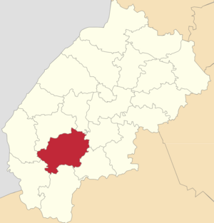
Drogobych district ( Ukrainian: Drogobitsky district ) is an administrative unit of the Lviv region of Ukraine . The administrative center is the city of Drohobych .
| area | |||||
| Drohobych district | |||||
|---|---|---|---|---|---|
| Drogobitsky district | |||||
| |||||
| A country | Ukraine | ||||
| Included in | Lviv region | ||||
| Includes | 2 village, 45 village councils | ||||
| Adm. Centre | Drohobych | ||||
| History and Geography | |||||
| Date of formation | 1959 year | ||||
| Square | 1,217 km² | ||||
| Timezone | , in the summer | ||||
| Population | |||||
| Population | 74 588 [1] people ( 2017 ) | ||||
| Digital identifiers | |||||
| Telephone code | +380 3244 | ||||
| Postal codes | 82119 | ||||
| Auto Code numbers | Sun | ||||
| KOATUU | 46212 all codes | ||||
 | |||||
Content
Geography
Drohobych district is located in the southwestern part of the Lviv region, in the foothills and mountain Carpathians . The region borders on the east with Nikolaev and Stryisk regions , in the north with Samborsky and Gorodoksky , in the south with Turkovsky and Skolevsky , in the west with Starosamborsky districts .
Eight village councils of Drogobychchyna have mountain status. The regional center is the city of regional subordination Drohobych. In addition, two more cities of regional subordination ( Borislav and Truskavets ) are located within the district. The largest settlements on the territory of the Drogobych district itself are urban settlements of Medenichi and Podbuzh . The territory and population of all these three cities are not included in the total territory and population of the district. The rivers Stry, Tysmenytsya, Bystrica, Bar, Kolodnitsa and Solonitsa flow through the territory of the Drogobych district.
The territory of the district stretches 36 km from north to south, 48 km from west to east. Within the modern borders, the Drogobych district occupies 121073 hectares or 1210.7 square kilometers, including the mountainous part of the region - 27879 hectares. Three agro-soil zones are distinguished within the region - the northern (Transnistrian), southern (foothills of the Drohobych) and mountain.
The largest territory (over 22 thousand hectares) is occupied by the southern zone of the foothills with sod-podzolic, which make up 38.5 percent of all agricultural land. The northern (Transnistrian) lowland zone of sod-podzolic and meadow, mainly loamy soils occupies 30 percent of all agricultural land. The mountain zone of brown mountain-forest and sod-brown-green loamy soils occupies 31.5 percent of all agricultural land. The relief of the district is a mountainous area, divided by numerous streams into separate watershed plateaus with gentle or steep slopes. The main species of trees growing in the Drogobych district: oak - 30%, fir - 21%, beech - 23% and spruce - 15%.
The area is rich in deposits of raw materials for the production of bricks , tiles , oil , gas , sand and gravel materials and sources of mineral water . On the territory of the district there is a Skhodnitskoye oil field , which is practically exhausted.
Population
According to the results of the All-Ukrainian census of 2001, 76.3 thousand people lived in the district (97.9% compared to the 1989 census), of which 0.2 thousand people (0.3%) were Russian and 0.3 thousand were Poles . people (0.4%) [2] .
Farm
The area is purely agricultural. In the use of peasants are 64 thousand agricultural land. Both field cultivation and cattle breeding are practiced. Industrial production occupies an insignificant part in the economy of the region. The leading industry is baking. Important industrial centers of the region are enclave located within the city district of regional subordination Drohobych and Borislav; Truskavets is a resort of international importance.
Notes
- ↑ The number of people on the 1st grass of 2017 year of rock and the average number of people in 2017 is rooku // Head statistics department in Lviv region
- ↑ National warehouse of the population / Lviv region
Also in the Drohobych district there is a village, with which it is very large, Stebnik
![Flag [d]](http://upload.wikimedia.org/wikipedia/commons/thumb/1/13/Flag_of_Drohobych_raion.svg/160px-Flag_of_Drohobych_raion.svg.png)
![Coat of arms [d]](http://upload.wikimedia.org/wikipedia/commons/thumb/6/67/Drohobych_Raion_Herb.png/90px-Drohobych_Raion_Herb.png)